| Monday | Monday Night | Tuesday | |
|---|---|---|---|
| Cloud Cover: | Snow showers taper in Whitefish Range, while lingering in Flathead and Swan Ranges. | Snow tapers. | Another system moves into the area in the afternoon/evening. |
| Temperatures: | 29-35 deg. F. | 17-24 deg. F. | 25-35 deg. F. |
| Wind Direction: | W-SW | SW | S-SW |
| Wind Speed: | 8-14 gusts 21-28 | 7-10 gusts 21 | 6-7 |
| Snowfall: | 1-3 in. | 0 in. | 0-1 in. |
| Snow Line: |
Swan Range
How to read the forecast
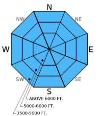
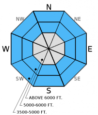
In the past 24 hours wet, heavy snow fell on less consolidated snow from the previous storm cycle. Given the new storm slabs and existing variability with persistent slabs the avalanche danger is HIGH above 6000 feet and CONSIDERABLE below 6000 feet. Avoid avalanche terrain at the upper elevations and all run-out zones. Both human triggered and natural avalanches are likely.

4. High
?
Above 6500 ft.
3. Considerable
?
5000-6500 ft.
3. Considerable
?
3500-5000 ft.
- 1. Low
- 2. Moderate
- 3. Considerable
- 4. High
- 5. Extreme
-
Type ?
-
Aspect/Elevation ?

-
Likelihood ?CertainVery LikelyLikelyPossible
 Unlikely
 -
Size ?HistoricVery LargeLargeSmall

Temperatures were on the rise as the snow fell yesterday afternoon and overnight forming an "upside down" storm slab. Though 24 hour snow totals are not impressive we did receive a substantial amount of snow water equivalent (up to 0.9 inches at Noisy Basin SNOTEL). With deeper instabilities lingering in the snowpack the potential exists for a smaller storm slab avalanche to step down into a deeper layer. Recent wind slabs formed on top of a variety of surfaces that can cause instability to linger including sun crusts, freezing rain crusts and buried surface hoar. Wind slabs will be thicker at upper-elevations in the precipitation favored Swan Range and in areas near the Continental Divide where wind speeds have been stronger. Look for smooth, rounded features on the slope especially on steep convex rollovers, on leeward sides of ridges and cross-loaded gullies. Wind slabs could be over 4-5 feet thick making them very dangerous.
-
Type ?
-
Aspect/Elevation ?

-
Likelihood ?CertainVery LikelyLikelyPossible
 Unlikely
 -
Size ?HistoricVery LargeLargeSmall

Warming temperatures yesterday created a slab in areas where the snow had been previously unconsolidated. There is a lot of variability across the advisory area with this problem that warrants careful snowpack evaluation and cautious route-finding. Surface hoar and weak, faceted snow were observed in all ranges, but you won't find them on all slopes. These weak layers are now 1.5 to 4 feet deep after the recent storm. Surface hoar is notorious for propagating long distances across a slope, around corners, and through the trees. Given the tricky distribution of these persistent slabs it would be wise to avoid steep, open slopes and convexities. Look for obvious signs of instability like recent avalanche activity, shooting cracks, and whumpfing.
-
Type ?
-
Aspect/Elevation ?

-
Likelihood ?CertainVery LikelyLikelyPossible
 Unlikely
 -
Size ?HistoricVery LargeLargeSmall

This problem will be amplified in the Swan Range where the snow is deeper, and in many areas remains dry and unconsolidated. The potential exists for loose, wet avalanches to knock you off your feet or sled and even entrain enough snow to bury you. Use extra caution when traveling near terrain traps like narrow gullies, steep treed areas, and cliffs. With temperatures remaining near the freezing mark overnight watch for signs of increasing loose, wet avalanche danger if temperatures rise more than expected. Early signs of instability include surface snow that becomes moist and roller balls forming steep slopes and cutbanks.
Yesterday, Mark was in Canyon Creek in the southern Whitefish Range with an avalanche class and saw small sluffs and roller balls forming on steep slopes late in the day. Skiers in Spider Bowl in the Swan Range noted that the surface snow became heavy as the day progressed and there was a thin crust forming up to 8000 feet. Skiers in Chicken Creek in the northern Whitefish Range found the January 12 freezing rain crust to be reactive in stability tests (observation). Skiers in the Flathead Range returned to the area that they were on the previous day and found similar stability test results, but the snow had become more dense (observation).
Saturday, we were in Noisy Basin in the Swan Range where we saw widespread recent avalanche activity (photo). Several of the the avalanches were relatively shallow and occured early in the recent storm cycle, while others failed on the weak snow formed in early Jan. and were 3-3.5 feet deep (observation).
Skiers in the Flathead Range on Saturday also noted recent avalanche activity and found instability within storm snow and on the Jan. 12 freezing rain crust (observation). Skiers on Ghoulie Point in the southern Whitefish Range found a freezing rain crust buried 2 feet deep in the snowpack that was minimally reactive in stability testing. A seperate party of skiers on Skookoleel Face, also in the southern Whitefish Range found the new snow/old snow interface to be reactive in stability testing (ECTP 16 Q2 35cm from the surface). Snowmobilers in the six-mile area in the Swan Range reported recent natural activity. They estimated the width at 100 feet with a 2-3 foot crown.
On Friday a party of skiers triggered multiple avalanches that were reported as 16 inches deep. These avalanches occured on the south side of Ghoulies outside of the ski area boundary in the southern Whitefish Range. One skier was caught and carried through the trees, and luckily only sustained minor injuries. BNSF Avalanche Safety reported a natural avalanche in the Java Creek drainage in the Flathead Range (photo). Another natural avalanche was observed by a group of snowmobilers riding on Doris Ridge in the Swan Range.
On Friday we were in the Lost Johnny and Doris Creek drainages in the Swan Range and found up to 2.5 feet of recent, unconsolidated snow at low elevation. Though the rain that came with the arrival of the system began to decompose buried surface in the mid-elevation band, it was still present in the snowpack.
Thursday, Erich easily triggered a storm slab (12-16 inches deep and 50 feet wide) from the top of a flat, safe ridge just east and outside the boundary of Whitefish Mountain Resort (video, photo). The slab failed on the freezing rain crust that formed Wednesday (1/12/2016). Also, on Thursday in John F. Stevens Canyon in southern Glacier NP, BNSF Avalanche Safety observed 3 natural wind slab avalanches and intentionally triggered another on a test slope (photo, observation). The deepest part of the slab was 50 inches deep and failed on buried surface hoar.
Thanks to everyone for submitting observations. They are extremely useful for everyone.
Visit our Observations page and our You Tube channel for more observations from the entire season.
Please let us know what you are seeing out there. Your observations are important and valued.
HOW TO SUBMIT OBSERVATIONS:
Email: [email protected]
Call and leave a message: 406.387.3821
You can also submit quick observations via text: 406.241.4571 (FAC mobile)
OR
Submit Snowpack Observations: http://www.flatheadavalanche.org/node/add/snowobs
Submit Avalanche Observations: http://www.flatheadavalanche.org/node/add/avyobs
Temperatures warmed yesterday and continue to hover near the freezing mark. We picked up an additional 2-4 inches of heavy snow with snow water equivalents ranging from .15 inches to 0.9 inches (Noisy Basin SNOTEL). Currently mountain temperatures range from 25º-31º F and winds are light with moderate gusts out of the west and southwest. Today, the current temperatures are about as high as we will see as we begin to cool through the day. Snow showers are expected to taper mid-day in the Whitefish Range and continue in the Swan and Flathead Ranges. Winds will continue out of southwest at 5-15mph with gusts in the mid 20s.
| 0600 temperature: | 25-31 deg. F. |
| Max. temperature in the last 24 hours: | 28-32 deg. F. |
| Average wind direction during the last 24 hours: | SW |
| Average wind speed during the last 24 hours: | 5-10 mph |
| Maximum wind gust in the last 24 hours: | 20-25 mph |
| New snowfall in the last 24 hours: | 2-4 inches |
| Total snow depth: | 55-79 inches |
This advisory applies only to backcountry areas outside established ski area boundaries. This advisory describes general avalanche conditions and local variations always occur. This advisory expires at midnight on the posted day unless otherwise noted. The information in this advisory is provided by the USDA Forest Service who is solely responsible for its content.


