| Wednesday | Wednesday Night | Thursday | |
|---|---|---|---|
| Cloud Cover: | Becoming cloudy. | Mostly cloudy. | Mostly cloudy |
| Temperatures: | 25-35 deg. F. | 14-21 deg. F. | 17-26 deg. F. |
| Wind Direction: | East | East | East |
| Wind Speed: | 3-4 | 5-6 | 9-10 gusts 20 |
| Snowfall: | 0 in. | 0-1 in. | 1 in. |
| Snow Line: |
Whitefish Range
Swan Range
Flathead Range and Glacier National Park
How to read the forecast
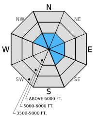
The avalanche danger is MODERATE on steep wind loaded slopes above 6000 feet and human triggered avalanches are possible. Wind slabs of varying age exist across the advisory area. Carefully evaluate the snowpack before committing to a slope, particularly in steep, wind loaded terrain. The avalanche danger is LOW on all other slopes and normal safe travel practices should be used.

2. Moderate
?
Above 6500 ft.
1. Low
?
5000-6500 ft.
1. Low
?
3500-5000 ft.
- 1. Low
- 2. Moderate
- 3. Considerable
- 4. High
- 5. Extreme
-
Type ?
-
Aspect/Elevation ?

-
Likelihood ?CertainVery LikelyLikelyPossible
 Unlikely
 -
Size ?HistoricVery LargeLargeSmall

Recent south through westerly winds have formed thin wind slabs on leeward aspects and crossloaded slopes. It is important to continue to treat all wind loaded areas as suspect and carefully evaluate this terrain before skiing or riding in it. Look for smooth, rounded features on the slope or deeper deposition areas around features like tree islands or rocks. Remember, that even a small avalanche can have severe consequences if you trigger it in or around terrain traps.
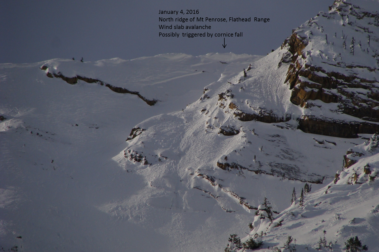
As always, pay attention to changing weather conditions. Temperatures at mid and upper elevations will be near to above freezing again today. These warm air temps will weaken existing cornice features. A recent cornice failure, and resulting avalanche, was observed Monday in the Middle Fork. Surface snow in the low elevation bands in many locations remained cold and unconsolidated due to recent temperature inversion and shading from the stratus layer. As this layer warms with the current temperature trend, and possible solar radiation, look for signs of surface instability like snow that becomes moist and roller balls/pin-wheels on steep slopes and cutbanks. Small, loose, wet avalanches can be dangerous in the wrong terrain like narrow gullies, timbered areas, and around cliffs.
If you are out on the snow today, pay attention to the distribution of the next potential buried weak layers like surface hoar and weak, faceted snow near the surface. This will give you a head start at identifying future concerns as this weak snow becomes buried in the next round of snow.
There are currently two deeper layers in the snowpack that still pose concern, particularly in areas with a shallow snowpack. We haven't observed or received reports of avalanches on these layers (even during or after last week's storms) or reactiveness in stability tests, but they are easily identifiable and worthy of investigation in your snowpit due to their variablity.
1. In some locations throughout the advisory area we noted and have received observations of weak, sugary snow (facets) near the ground. This layer has not been reactive in stability tests in over three weeks, but in shallow areas (snowpack less than 3-4 feet deep) this layer may be more developed and could be more reactive. It is best to avoid areas of shallow snowpack where this layer exists (like steep, rocky slopes).
2. The December 9 rain crust still lurks throughout most of the advisory area. A layer of softer facets (weak, sugary snow) below the crust has shown no signs of instability (fracture or propagation) in our snowpits for two weeks, but it's still there. It is unlikely you'll trigger an avalanche on this layer, but not impossible. It is still worth taking the time to dig into the snow and see how it is reacting in the areas that you are skiing or riding.
Yesterday, Erich travelled to Red Meadow Peak in the northern Whitefish Range. He observed southerly winds that were loading northerly aspects at upper elevations. He also noted that this area did not receive as much snow during the pre-Christmas storm cycle and therefore there is only about 3 feet of snow resting on the December 9 rain crust in this location (video, observation).
Also on Tuesday, experienced skiers in the Middle Fork reported sun crust conditions on a southeast aspect of Mt Penrose. They also noted substantial sluffing of the dry loose surface snow while skiing a steep northeast aspect into Rescue Creek. The quantity of this sluffing surprised them.
Monday, my partner and I traveled into the Rescue Creek drainage in the Flathead Range. We observed a recent wind slab avalanche that appears to have been triggered by a cornice fall (photo, observation). We also noticed recent small loose snow avalanches on sunny aspects. Warm morning air temps combined with solar radiation quickly moistened the snow surface on sunny aspects on elevations up to 7200+feet (observation).
Sunday,skiers in the Cascadilla Drainage in the Flathead Range found minimal results in stability testing and noted some minor wind loading at upper elevations (observation). Another party in the Snyder Lakes Basin in Glacier National Park observed recent point-release and thin, wind slab avalanche activity on multiple aspects and in the upper elevation found thin, stiff windslab that was unreactive. Skiers on Elk Mountain, also in Glacier National Park found variable conditions including windslab, scoured areas, surface hoar, and near-surface facets (observation).
Saturday, Erich was on Nyack Peak in the Flathead Range and witnessed a natural, wind slab avalanche on a steep, north facing slope as well as another recent avalanche. He also noted wind drifting the snow onto north and east aspects above 5500 feet (observation).
Also on Saturday, Todd and I were in the Swan Range on the Mt Aeneas ridge where moderate east wind was transporting the recent snow along the high ridgelines (photo). Late in the afternoon the sun caused the surface snow to become moist and we observed several small, loose snow avalanches as a result (photo). Early in the day we noted a thin, surface crust on sunny aspects that was formed the previous day.
Snowboarders on Mt. Brown in Glacier National Park found weak snow in the lower snowpack and also noted weak, faceted snow forming beneath the recent sun crust near the surface (observation).
Snowboarders in the Wahoo Creek drainage in the Flathead Range found recent wind slabs that were reactive in stability tests and wind drifting occurring at the upper elevations (observation). Also in Flathead Range, skiers near Stanton Lake found a shallow snowpack with weak snow near the ground that was reactive in stability tests (observation).
Thanks to everyone for submitting observations. They are extremely useful for everyone.
Visit our Observations page and our You Tube channel for more observations from the entire season.
Please let us know what you are seeing out there. Your observations are important and valued.
HOW TO SUBMIT OBSERVATIONS:
Email: [email protected]
Call and leave a message: 406.387.3821
You can also submit quick observations via text: 406.241.4571 (FAC mobile)
OR
Submit Snowpack Observations: http://www.flatheadavalanche.org/node/add/snowobs
Submit Avalanche Observations: http://www.flatheadavalanche.org/node/add/avyobs
Today will be the last day of the recent unusually warm conditions at mid and upper elevations. Tonight, a cold air mass east of the Continental Divide will make it's way into our area bringing colder air temperatures and brisk easterly winds. Currently, mountain temperatures are still a relatively balmy 25º-34º F with mostly clear skies and light winds out of the south - southeast. Today should see clouds moving in with temperatures in the upper 20s to mid 30s and winds out of the east through southeast at 0-5 mph.
| 0600 temperature: | 25-34 deg. F. |
| Max. temperature in the last 24 hours: | 29-37 deg. F. |
| Average wind direction during the last 24 hours: | SW |
| Average wind speed during the last 24 hours: | 0-11 mph |
| Maximum wind gust in the last 24 hours: | 6-15 mph |
| New snowfall in the last 24 hours: | 0-1 inches |
| Total snow depth: | 45-58 inches |
This advisory applies only to backcountry areas outside established ski area boundaries. This advisory describes general avalanche conditions and local variations always occur. This advisory expires at midnight on the posted day unless otherwise noted. The information in this advisory is provided by the USDA Forest Service who is solely responsible for its content.


