| Thursday | Thursday Night | Friday | |
|---|---|---|---|
| Cloud Cover: | Light/Moderate snow showers. | Snow beginning to taper. | Light snow showers lingering. Cooler temps. |
| Temperatures: | 20-28 deg. F. | 1-14 deg. F. | 16-23 deg. F. |
| Wind Direction: | S-SW | E-SE | SE-NE |
| Wind Speed: | 3-8 | 5-6 gusts 16-17 | 4-5 gusts 16 |
| Snowfall: | 3-8 in. | 1-4 in. | 0-2 in. |
| Snow Line: |
Swan Range
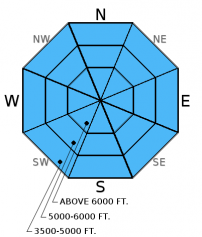
How to read the forecast
In the past 3 days the Swan Range received 3.8 inches of snow water equivalent. The avalanche danger above 6000 feet is HIGH, human triggered avalanches are very likely. Below 6000 feet the danger is CONSIDERABLE cautious route-finding, careful snowpack evaluation, and conservative decision making are essential.

4. High
?
Above 6500 ft.
3. Considerable
?
5000-6500 ft.
3. Considerable
?
3500-5000 ft.
- 1. Low
- 2. Moderate
- 3. Considerable
- 4. High
- 5. Extreme
-
Type ?
-
Aspect/Elevation ?

-
Likelihood ?CertainVery LikelyLikelyPossible
 Unlikely
 -
Size ?HistoricVery LargeLargeSmall

We have not received any recent observations from the Swan Range so there is some uncertainty in the conditions, but the numbers are impressive. In the past 3 days Noisy Basin SNOTEL reported 30 inches of new snow and 3.8 inches of snow water equivalent. Abundant new snow at all elevations has created a storm slab concern. On steeper convex rollovers soft slabs were easily triggered in the past few days, and I suspect these slabs will still be sensitive on steep slopes today. We observed small natural storm slabs on steep slopes at low elevation yesterday. Because this is a surface snow problem it is easy to identify. Dig into the new snow and see how this layer is bonding to the recent snow from this weekend. This new snow needs time to stabilize so cautious route finding and conservative decision making are essential again today.
-
Type ?
-
Aspect/Elevation ?

-
Likelihood ?CertainVery LikelyLikelyPossible
 Unlikely
 -
Size ?HistoricVery LargeLargeSmall

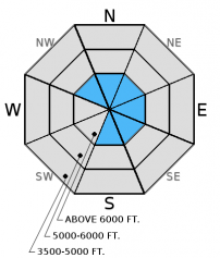
Several observations from the southern Whitefish Range reported cohesionless surface snow and minimal wind slab formation, but without wind data or recent observations from the Swan Range it is best be on the look out for and avoid recent wind slabs. Keep in mind that recent wind slabs may be more difficult to identify with new snow on top. Look for obvious signs of instability like cracking and collapsing in denser pockets of snow.
-
Type ?
-
Aspect/Elevation ?

-
Likelihood ?CertainVery LikelyLikelyPossible
 Unlikely
 -
Size ?HistoricVery LargeLargeSmall

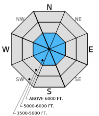
The primary persistent slab concern continues to be the weak, faceted snow above and below the Dec. 9 crust. This layer is generally found now 2.5 to 3.5 feet from the surface and exists in most locations across the advisory area. So far, we have not seen avalanche activity associated with this weak snow, but it is hard to say just how much weight it can handle. Continue to dig into the snow and assess this layer before committing to a slope and keep in mind the additional stress we put on this weak snow as this active weather pattern continues.
With the recent abundant snow fall pay attention to loose snow avalanches in steep terrain. They are easy to manage but can pack a punch if they catch you off guard, especially while traveling in and around terrain traps.
In some locations in the Flathead Range, Glacier Park, and parts of the Swan Range we noted and have received observations of weak, sugary snow near the ground. In some places it breaks and propagates across a column in stability tests, and sometimes it doesn't even break. With the December 9 rain crust fairly thick in places, it makes affecting these deeper layers more difficult. Though it appears very isolated in distribution, it is worth mentioning that skiers in the southern Whitefish Range found buried surface hoar Sunday which further illustrates the importance of digging in the snow to see what is going on below you.
Yesterday Erich traveled to the Ghoulie Point area in the southern Whitefish Range and found cohesionless surface snow near the ridgeline. At low elevation (below 5000 feet) he noted recent natural avalanche activity in the form of very thin soft slabs (4-5 inches thick) that failed and propagated fairly wide on steep cutbanks due to storm snow that was slightly heavier.
A seperate party in the Ghoulie Point area also noted cohesionless surface that did not react in stability tests (observation).
Thursday, Erich was in the Marion Lake area in the Flathead Range (observation 1 and video) They stuck to slopes much less than 35 degrees. There was about 14-16 inches of light, new snow that on small convex rollovers formed soft slab avalanches (observation 2 and photo). They did not propagate very wide, but the slopes were relatively small. The debris entrained enough snow
On both Sunday and Monday BNSF Avalanche Safety reported natural avalanche activity in the John F Stevens Canyon. Sundays avalanches were thin wind slabs (10-12 inches) that failed Saturday night and Sunday morning (observation and photo).
On Sunday Todd traveled to Red Meadow in the northern Whitefish Range Sunday and found 15-20 inches of snow on top of the Dec. 9 crust. This crust was nearly 5 inches thick (Photo) at 7200 feet and though weak snow existed around the crust it did not fail in stability tests.
Also on Sunday, skiers on the Autumn Creek trail in southern Glacier National Park observed wind drifting snow on surrounding peaks and found the Dec. 9 crust was decomposing 2 feet from the surface (Observation). Other skiers were on Skookoleel Ridge in the southern Whitefish Range and in an isolated location found buried surface hoar that failed and propagated in stability tests (Observation).
Visit our Observations page and our You Tube channel for more information from the entire season.
Please let us know what you are seeing out there. Your observations are important and valued.
HOW TO SUBMIT OBSERVATIONS:
Email: [email protected]
Call and leave a message: 406.387.3821
You can also submit quick observations via text: 406.241.4571 (FAC mobile)
OR
Submit Snowpack Observations: http://www.flatheadavalanche.org/node/add/snowobs
Submit Avalanche Observations: http://www.flatheadavalanche.org/node/add/avyobs
The active weather pattern continues to deliver. In the past 24 hours we picked up 3-10 inches of new snow. Again, the Swan Range saw the most with 10 inches of snow (1.00 inches of snow water equivalent). Currently, mountain temperatures range from 14º-21º F and winds are out of the southwest at 2-7 mph. Today, expect light to moderate snow showers to continue, temperatures will reach the low to mid 20s with winds moving 5-10 mph out of the southwest.
| 0600 temperature: | 14-21 deg. F. |
| Max. temperature in the last 24 hours: | 14-21 deg. F. |
| Average wind direction during the last 24 hours: | SW |
| Average wind speed during the last 24 hours: | 3-8 mph |
| Maximum wind gust in the last 24 hours: | 5-15 mph |
| New snowfall in the last 24 hours: | 2-10 inches |
| Total snow depth: | 59-68 inches |
This advisory applies only to backcountry areas outside established ski area boundaries. This advisory describes general avalanche conditions and local variations always occur. This advisory expires at midnight on the posted day unless otherwise noted. The information in this advisory is provided by the USDA Forest Service who is solely responsible for its content.


