| Wednesday | Wednesday Night | Thursday | |
|---|---|---|---|
| Cloud Cover: | Rain. Cold front passing through later today. | Decreasing precipitation with cooling temperaturs | Scattered snow with decreasing winds |
| Temperatures: | 35-45 deg. F. | 20-27 deg. F. | 27-37 deg. F. |
| Wind Direction: | southwest | southwest | south |
| Wind Speed: | 20-30 with gusts to 60 | 20-30 with gusts to 60 | 5-10 with gusts to 20 |
| Snowfall: | 0-1 in. | 0-1 in. | 1-3 in. |
| Snow Line: |
Whitefish Range
Swan Range
Flathead Range and Glacier National Park
How to read the forecast
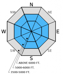
AVALANCHE WARNING. Above 6000' the avalanche danger is HIGH. Recent substantial rain has put a lot of weight onto a shallow weak snowpack over a very short time span. Dangerous avalanche conditions exist today and travel in avalanche terrain is not recommended. We will either continue or let the warning expire by 7:00 am tomorrow.

4. High
?
Above 6500 ft.
3. Considerable
?
5000-6500 ft.
No Rating
?
3500-5000 ft.
- 1. Low
- 2. Moderate
- 3. Considerable
- 4. High
- 5. Extreme
-
Type ?
-
Aspect/Elevation ?

-
Likelihood ?CertainVery LikelyLikelyPossible
 Unlikely
 -
Size ?HistoricVery LargeLargeSmall

Today's main concern is the copious amount of rain that has fallen, and continures to fall, on the recent storm slab. Rain adds weight to the snowpack but unlike snow does not add any strength to the pack. With today's forecast of continued rain and warm weather this slab will be tested. Within this storm slab are recently formed wind slabs found on leeward aspects which range from north to east. These thick slabs, combined with the weight of the rain, will also be put to the test. With warm air temps and continued rainfall there is the possibility for wet slab avalanches as well. Look for obvious signs of instability like cracking, collapsing, and recent avalanche activity. Stay on slopes less than 30 degrees and out from under obvious avalanche paths.
-
Type ?
-
Aspect/Elevation ?

-
Likelihood ?CertainVery LikelyLikelyPossible
 Unlikely
 -
Size ?HistoricVery LargeLargeSmall

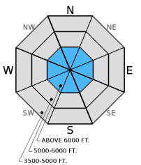
With rain continuing throughout the day wet loose avalanches are a concern in the surface snow. Rollerballs, or pinwheels, are the first warning sign of these wet loose slides.
-
Type ?
-
Aspect/Elevation ?

-
Likelihood ?CertainVery LikelyLikelyPossible
 Unlikely
 -
Size ?HistoricVery LargeLargeSmall

Our third concern today is the persistent slab found in the lower third of the snowpack. This slab consists of a strong thick rain crust that was deposited in mid-November and is sandwiched by weak faceted snow. The weight of the newly formed storm slab combined with rainfall could tip the balance. With minimal knowledge of how this persistent slab handles a substantional stress it is best to err on the side of caution today and give this problem a wide berth.
This is the first substantional storm of the season and it is falling on a shallow weak snowpack. Our snowpack has received a substantial load in terms of recent snow and rain and needs to time to adjust to this. The lack of low elevation snow has made access into many of the upper elevations areas difficult and has limited our observations. Due to our lack of observations we are being conservative in our danger rating by issuing an AVALANCHE WARNING. Today is the day to err on the side of caution and not recreate in avalanche terrain. Instead, today is a great day to practice safe travel techniques and enjoy low angle slopes well away from avalanche runout zones. We have not issued an avalanche danger rating for low elevations in our forecast area due to minimal to no snow. However treat all slopes as suspect if you encounter snow at this elevation.
HOW TO SUBMIT OBSERVATIONS:
Email: [email protected]
Call and leave a message: 406.387.3821
You can also submit quick observations via text: 406.241.4571 (FAC mobile)
OR
Submit Snowpack Observations: http://www.flatheadavalanche.org/node/add/snowobs
Submit Avalanche Observations: http://www.flatheadavalanche.org/node/add/avyobs
On Monday, we received a report from Skookoleel Ridge in the southern Whitefish Range (observation). Skiers reported mixed results in their stability tests but did note red flags within the new snow and from windloading. We also received an observation from Jewel/Noisy Basin in the Swan Range (observation) where skiers noted active wind loading along ridges. Last week we made a video from Red Meadow in the northern Whitefish Range that shows our weak snowpack.
Yesterday, we stayed off of steep slopes in the southern Whitefish Range and found the mid-November rain crust and about 12 inches of new snow.
Heavy precipitation, strong winds and unusually warm weather continue to affect our entire advisory area. Snow levels have risen bringing rain to all but the highest peaks in our region. Over the past 24 hours precipitation has favored the northern end of our advisory area with Flattop Mountain in the northern Lewis Range reporting 2.1 inches of precipitation, Stahl Peak in the northern Whitefish Range clocking in with 1.3 inches of precipitation, Graves Creek (4300') in the northern Whitefish Range reporting 3.1 inches, the Big Mountain weather station in the southern Whitefish Range reporting approximately 1 inch of water and Java East weather station (4040') in John F. Stevens Canyon reporting 2.17 inches. Air temperatures will remain well above average through the daylight hours before a cold front moves in later today dropping temperatures down to more December like values. Precipitation in the form of rain will plague our area throughout the day before tapering off and transitioning to snow showers later today.
| 0600 temperature: | 34-37 deg. F. |
| Max. temperature in the last 24 hours: | 27-39 deg. F. |
| Average wind direction during the last 24 hours: | west - southwest |
| Average wind speed during the last 24 hours: | 9-22 mph |
| Maximum wind gust in the last 24 hours: | 17-38 mph |
| New snowfall in the last 24 hours: | 0-3 inches |
| Total snow depth: | 23-39 inches |
This advisory applies only to backcountry areas outside established ski area boundaries. This advisory describes general avalanche conditions and local variations always occur. This advisory expires at midnight on the posted day unless otherwise noted. The information in this advisory is provided by the USDA Forest Service who is solely responsible for its content.


