| Sunday | Sunday Night | Monday | |
|---|---|---|---|
| Cloud Cover: | Partly cloudy and cool | Increased wind and snow | Snow showers continue |
| Temperatures: | 31-43 deg. F. | 21-30 deg. F. | 32-42 deg. F. |
| Wind Direction: | east | east | east/southeast |
| Wind Speed: | 9 gusts 22-24 | 14 gusts 25-29 | 7-8 gusts 17-20 |
| Snowfall: | 0 in. | 2-3 in. | 2 in. |
| Snow Line: |
Whitefish Range
How to read the forecast
Generally safe conditions exist in the Whitefish Range. The hazard is LOW, however with a bit of sun today the recent snow may weaken and produce very small, loose, wet avalanches. Thin wind slabs also exist in the upper elevations and it is important to remember that even a small avalanche can be dangerous is consequential terrain. A notable Spring storm that is expected to move into the region tonight and tomorrow will cause the hazard to rise.

1. Low
?
Above 6500 ft.
1. Low
?
5000-6500 ft.
1. Low
?
3500-5000 ft.
- 1. Low
- 2. Moderate
- 3. Considerable
- 4. High
- 5. Extreme
-
Type ?
-
Aspect/Elevation ?

-
Likelihood ?CertainVery LikelyLikelyPossible
 Unlikely
 -
Size ?HistoricVery LargeLargeSmall

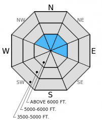
Thin wind slabs exist in the upper elevations. Be sure to assess slopes for recent wind slabs and avoid steep, consequential terrain where small avalanches can be dangerous. With a wind shift expected today, we may start to see atypical wind loading patterns late in the day.
-
Type ?
-
Aspect/Elevation ?

-
Likelihood ?CertainVery LikelyLikelyPossible
 Unlikely
 -
Size ?HistoricVery LargeLargeSmall

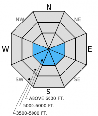
Periods of sun today are not likely to thaw the thick melt-freeze crust that formed over the past few days. However, it won't take much to sun to moisten the recent snow on top of this crust. We could see surface snow become moist and capable of producing small, loose, wet avalanches late in the day on the sunny aspects. Look for the signs that the sun is affecting the recent snow like roller balls and pin wheels and move to a shaded slope when this begins. Speaking of shaded slopes, recent unconsolidated snow atop the slick melt-freeze crust will easily slide on steep slopes. These loose avalanches will only be as deep as the recent snow, but could entrain quite a bit if they are confined to gullies or consistently steep slopes.
A notable spring storm is expected to move into the area tonight and into tomorrow. The new snow that is expected with the approaching system will cause the hazard to rise. Continue to pay close attention to changing weather and snow pack conditions as we move deeper into Spring.
This is the last scheduled advisory of the season. Check back tomorrow for a spring avalanche statement.
We would like to thank all of you who helped support the Flathead Avalanche Center this season. Thank you.
On Friday, two skiers were caught in a cornice triggered, loose snow avalanche on Appistoki Peak in Glacier National Park, they were carried 200 feet. Thankfully no one was injured. Another skier in the party triggered a wind slab on their descent. Though this incident occurred just outside of the advisory area, it is certainly representative of the conditions that exist locally (observation).
Yesterday we were on Hash Mountain in the Swan Range, where we found an impressive melt-freeze crust (photo). The crust was nearly a foot thick and easily supported the weight of a snowmobile. There were 5 inches of recent snow atop this crust that easily sluffed on steep slopes. The recent, thin wind slabs in this area were confined to just below the ridgeline and would produce short cracks when approaching the slope (photo).
Yesterday the Flathead and Swan Ranges picked up 5-6 inches of snow while the Whitefish Range saw 1-3 inches. Currently mountain temperatures range from 17º-22º F and winds are out of the west and northwest at 4-6 mph. Today should see partly/mostly cloudy skies and a few light snow showers early. Winds are expected to shift out of the east at 5-10 mph with gusts in the 20s. Tonight, a storm moves into the area and continues into tomorrow, bringing up to a foot of new snow.
| 0600 temperature: | 17-22 deg. F. |
| Max. temperature in the last 24 hours: | 30-37 deg. F. |
| Average wind direction during the last 24 hours: | SW |
| Average wind speed during the last 24 hours: | 5-10 mph |
| Maximum wind gust in the last 24 hours: | 17-25 mph |
| New snowfall in the last 24 hours: | 1-6 inches |
| Total snow depth: | 59-102 inches |
This advisory applies only to backcountry areas outside established ski area boundaries. This advisory describes general avalanche conditions and local variations always occur. This advisory expires at midnight on the posted day unless otherwise noted. The information in this advisory is provided by the USDA Forest Service who is solely responsible for its content.


