| Friday | Friday Night | Saturday | |
|---|---|---|---|
| Cloud Cover: | Partly cloudy, light snow showers develop in the afternoon. | Snow showers | Snow showers continue |
| Temperatures: | 36-45 deg. F. | 23-30 deg. F. | 36-46 deg. F. |
| Wind Direction: | SW | SW | SW |
| Wind Speed: | 9-10 gusts 23-24 | 7-8 gusts 20-12 | 11-12 gusts 23-25 |
| Snowfall: | 0 in. | 1 in. | 1-3 in. |
| Snow Line: |
Flathead Range and Glacier National Park
How to read the forecast
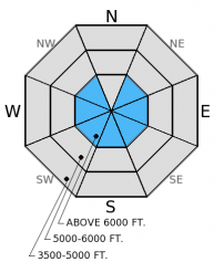
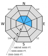
Spring weather in the mountains continues with periods of sun and warmth mixed with snow showers. 4-6 inches of new snow in the Flathead Range and Glacier National Park over the past 36 hours may cause some loose snow and wind slab problems. The hazard above 6000 ft. is MODERATE and the hazard below this is LOW. Human triggered loose snow and wind slab avalanches are possible particularly as it warms.

2. Moderate
?
Above 6500 ft.
1. Low
?
5000-6500 ft.
1. Low
?
3500-5000 ft.
- 1. Low
- 2. Moderate
- 3. Considerable
- 4. High
- 5. Extreme
-
Type ?
-
Aspect/Elevation ?

-
Likelihood ?CertainVery LikelyLikelyPossible
 Unlikely
 -
Size ?HistoricVery LargeLargeSmall

At this time of year the sun begins to have more and more of an effect on new snow. With 5-6 inches at around 5900 ft. near Marias Pass you can expect more at upper elevations. This is enough snow to knock you around especially if it entrains more as it moves dowhnhill. Even small loose avalanches can have big consequences in steep, rocky terrain or terrain traps. If the snow surface is becoming moist or you begin to see rollerballs or pinwheels, then it is time to move to shadier slopes.
-
Type ?
-
Aspect/Elevation ?

-
Likelihood ?CertainVery LikelyLikelyPossible
 Unlikely
 -
Size ?HistoricVery LargeLargeSmall

The wind slab problem should be one that only people traveling in the upper elevations will encounter. Even in the upper reaches these slabs could be up to a foot thick at most. Be sure to assess these slopes for recent wind slabs and avoid steep, consequential terrain where they are present.
Additional Concerns: Longer days and warmer temperatures may cause large cornices to weaken and fail. It is the time of year to avoid traveling below cornices and stay well behind them while traveling along ridgelines as they can break farther back than expected.
NOTE: Ortovox is recalling the S1+ avalanche transceiver. More info: http://www.ortovox.com/4875--handling_recall.html
The next regularly scheduled advisory will be issued Saturday, April 4, 2015. The final avalanche advisory of the season will be issued Sunday, April 5, 2015.
Going to the Sun Road avalanche specialists in Glacier National Park reported 4 inches of snow at lower elevations and a couple of very small loose snow sluffs at upper elevations. Skiers in southern Glacier National Park on Calf Robe Mountain reported deteriorating surface snow as soon as the sun began to affect slopes (observation).
Yesterday temperatures remained cool and snow showers favored areas near the Continental Divide and Glacier National Park where 4-6 inches of snow fell. Currently, mountain temperatures are in the high-teens to low-20s and winds are out of the SSW at 7-8 mph gusting to 15 mph. We should see some sun early today, and clouds will develop in the afternoon. Temperatures will rise to the upper-30s F and winds will blow out of the southwest at 5-15 mph with gusts in the mid-20s. Another shot of mountain snow is expected tonight into tomorrow morning.
| 0600 temperature: | 19-20 deg. F. |
| Max. temperature in the last 24 hours: | 27 deg. F. |
| Average wind direction during the last 24 hours: | SSW |
| Average wind speed during the last 24 hours: | 5-10 mph |
| Maximum wind gust in the last 24 hours: | 10-20 mph |
| New snowfall in the last 24 hours: | 4-6 inches |
| Total snow depth: | 60-93 inches |
This advisory applies only to backcountry areas outside established ski area boundaries. This advisory describes general avalanche conditions and local variations always occur. This advisory expires at midnight on the posted day unless otherwise noted. The information in this advisory is provided by the USDA Forest Service who is solely responsible for its content.


