| Saturday | Saturday Night | Sunday | |
|---|---|---|---|
| Cloud Cover: | Light showers with cooling temperatures | Showers taper, partial clearing | Mostly cloudy and warming |
| Temperatures: | 41-51 deg. F. | 29-34 deg. F. | 43-54 deg. F. |
| Wind Direction: | west | west/southwest | southwest |
| Wind Speed: | 20-23 gusts 39-44 | 12-17 gusts 28-33 | 11-14 gusts 23-42 |
| Snowfall: | 0-1 in. | 0 in. | 0 in. |
| Snow Line: |
Whitefish Range
Swan Range
Flathead Range and Glacier National Park
How to read the forecast
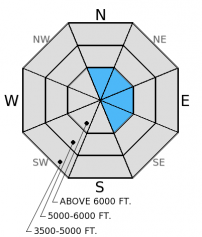
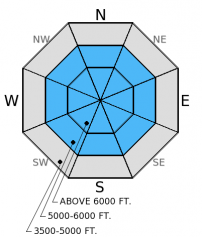
The hazard is MODERATE above 5000 feet and LOW below. A bit of new snow is expected today, accompanied by strong winds that will add depth to recently formed wind slabs. Mountain temperatures remain above freezing in most locations to start the day, so the possibility of triggering loose, wet avalanches remains. Pay close attention to changing conditions as hazard could rise with more snow than anticipated.

2. Moderate
?
Above 6500 ft.
2. Moderate
?
5000-6500 ft.
1. Low
?
3500-5000 ft.
- 1. Low
- 2. Moderate
- 3. Considerable
- 4. High
- 5. Extreme
-
Type ?
-
Aspect/Elevation ?

-
Likelihood ?CertainVery LikelyLikelyPossible
 Unlikely
 -
Size ?HistoricVery LargeLargeSmall

New upper elevation snow along with strong gusty winds will add stress to wind slabs formed over the past few days. Pay close attention to the weather today, as more snow than anticipated will translate to thicker and potentially more sensitive slabs. It's best to give these recently formed slabs time to adjust and avoid steep wind loaded areas along ridgelines and cross-loaded features like gullies and rock outcrops.
-
Type ?
-
Aspect/Elevation ?

-
Likelihood ?CertainVery LikelyLikelyPossible
 Unlikely
 -
Size ?HistoricVery LargeLargeSmall

Temperatures stayed above freezing in most areas last night, so the potential to trigger loose, wet avalanches remains. Though temperatures are expected to cool today, look for lingering instability this morning, particularly on slopes that were shaded and less settled yesterday. If the snow surface is wet avoid steep terrain and traveling near terrain traps like narrow gullies and cliffs.
The avalanche hazard today is largely based on the weather forecast, and as we know, spring weather can be finicky. Watch for changing conditions today, as more snow or higher snow levels than anticipated may cause the hazard to rise.
Potential weak layers about a foot from the surface exists on all aspects. On north (shaded) aspects it is a thin layer of small faceted grains above the mid-March rain crust. On sunny aspects it is a layer of very soft and still wet grains. The crust near the surface, however, is likely preventing much impact from reaching that layer, but as the surface crust potentially breaks down with rain, warming, and sunshine then these layers could become reactive. These layers have yet to become a problem, but it is worth checking out before you commit to a slope.
Access to the snow is becoming more difficult with the diminishing low elevation coverage. We traveled in the Skookoleel Ridge area in the southern Whitefish Range and found a wet, unstable snow surface on sunny aspects that easily produced loose, wet avalanches on small test slopes (photo). The warm temperatures also melted the crust and moistened the surface on shaded aspects at mid elevations.
Snowmobile observers Lucas and Guy were in the Lost Johnny/Strawberry Lake areas in the Swan Range where they saw recent loose, wet activity (photo), as well as wind slabs and wet slabs that appeared to have released on Thursday (photo 1, photo 2)
Yesterday, skiers in Jewel Basin in the Swan Range observed recent loose, wet avalanches (observation).
Yesterday saw another warm and sunny day, mountain temperatures reached the mid 50s. We picked up a bit of high elevation snow and valley rain this morning. Flattop Mountain and Stahl Peak SNOTEL sites both recorded 0.1 inches of precipitation. Currently, mountain temperatures remain warm and range from 29-43º F with winds out of the west/southwest at 4-11 mph and gusting to 21 mph. Today should be cooler than yesterday with high temperatures reaching the upper 30s to low 40s. Light snow/rain showers with lowering snow levels should continue through the early afternoon. Winds will increase today, expect ridgetop winds to 30 mph with gusts in the 40s.
| 0600 temperature: | 37-43 deg. F. |
| Max. temperature in the last 24 hours: | 42-55 deg. F. |
| Average wind direction during the last 24 hours: | SW |
| Average wind speed during the last 24 hours: | 5-10 mph |
| Maximum wind gust in the last 24 hours: | 15-25 mph |
| New snowfall in the last 24 hours: | 0 inches |
| Total snow depth: | 55-101 inches |
This advisory applies only to backcountry areas outside established ski area boundaries. This advisory describes general avalanche conditions and local variations always occur. This advisory expires at midnight on the posted day unless otherwise noted. The information in this advisory is provided by the USDA Forest Service who is solely responsible for its content.


