| Thursday | Thursday Night | Friday | |
|---|---|---|---|
| Cloud Cover: | Rain continuing this morning then tapering this afternoon. Clearing skies west to east as day progresses. | Clearing overnight as brief high pressure builds into the region. | Mostly clear and quite warm. |
| Temperatures: | 44-54 deg. F. | 34-39 deg. F. | 54-62 deg. F. |
| Wind Direction: | West - Southwest | West - Southwest | Southwest |
| Wind Speed: | 10-15 mph with gusts to 25 mph. | 5-10 mph with gusts to 20 mph. | 5-10 mph. |
| Snowfall: | 0 in. | 0 in. | 0 in. |
| Snow Line: |
Whitefish Range
Swan Range
Flathead Range and Glacier National Park
How to read the forecast
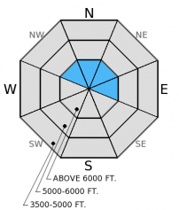
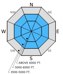
It's a mixed bag today - both dry and wet avalanche problems exist. New snow and wind over the past three days formed wind slabs above 6000 feet. Rain on snow, above freezing temperatures, and clearing this afternoon will create potential for wet avalanches. The hazard above 6000 feet today is CONSIDERABLE due to warming, rain, and wind slabs. Human triggered avalanches are likely. The hazard is MODERATE on all other terrain and LOW below 5000 feet.

3. Considerable
?
Above 6500 ft.
2. Moderate
?
5000-6500 ft.
1. Low
?
3500-5000 ft.
- 1. Low
- 2. Moderate
- 3. Considerable
- 4. High
- 5. Extreme
-
Type ?
-
Aspect/Elevation ?

-
Likelihood ?CertainVery LikelyLikelyPossible
 Unlikely
 -
Size ?HistoricVery LargeLargeSmall

Over the past three days 10-16 inches of new snow accumulated throughout the advisory area (favoring the Swan Range). Winds were moderate to strong at times over this period transporting this new snow into fresh wind slabs. Wind slabs appeared to be relegated to near the tops of ridges. These slabs could be over two feet thick and exist on leeward slopes and cross-loaded gullies. Wind slabs could be more sensitive today as the new snow is heavier creating an upside-down snowpack, and storm slabs may also become a concern. Assessing this problem is fairly straightforward given they are confined to the upper snowpack. Perform stability tests on the upper snowpack to identify the sensitivity of these slabs or any other layers of concern.
-
Type ?
-
Aspect/Elevation ?

-
Likelihood ?CertainVery LikelyLikelyPossible
 Unlikely
 -
Size ?HistoricVery LargeLargeSmall

The upper part of the snowpack (top 1-2 feet) remains mostly dry and winter-like. Rain on this new snow will cause instability and wet avalanches will become more likely as the upper snowpack becomes wet. Combine this with above freezing temperatures and potential sunshine this afternoon (locations near the Continental Divide will remain cloudy for most of the day) and we could see natural wet avalanche activity today. Human triggered wet loose avalanches are likely on slopes steeper than 35 degrees and with rain on snow up to 6500 feet we could even see wet slab avalanches involving the top part of the snowpack. If the snow surface is becoming wet and you begin to see rollerballs and pinwheels then it is time to move off of steep slopes and out of avalanche terrain. Even small wet loose avalanches can have a big impact in high consequence terrain like cliffs or terrain traps.
Potential weak layers about a foot from the surface exists on all aspects. On north (shaded) aspects it is a thin layer of small facted grains above the mid-March rain crust. On sunny aspects it is a layer of very soft and still wet grains. The crust near the surface, however, is likely preventing much impact from reaching that layer, but as the surface crust potentially breaks down with rain, warming, and sunshine then these layers could become reactive. These layers have yet to become a problem, but it is worth checking out before you commit to a slope.
Winter took over for a bit, but spring is right back on it's heels with rising temperatures and rain on snow. Access to upper elevation terrain is also becoming more "spring-like" (photo). Yesterday, in the Middle Fork of the Flathead Range we observed active wind loading above 6500 feet (photo). Wind slabs were relatively small and relegated to near ridges but likely grew larger with new snow and wind overnight. On north aspects we found a layer of small facets above the mid-March rain crust. It did not propagate in extended column tests, but is worth noting and looking for in snowpits (photo). On a southerly aspect the new snow sits on top of a near surface crust, but about a foot from the surface soft, weak, and wet snow still exists. This layer propagated in extended column tests with moderate force (photo).
It is classic spring northwest Montana weather today. As of 5:00 a.m. temperatures above 6000 feet range from 26º-35º F with winds moving out of the southwest at 6-7 mph with gusts to 15 mph. New snow amounts in the past 24 hours total 4-8 inches of heavy snow (0.4-1.2 inches snow water equivalent) with most of this falling since yesterday afternoon. Over the past three days 12-16 inches of snow accumulated above 6000 feet. Temperatures will rise into the 40s F today and winds become light to moderate (5-10 mph gusting to 30 mph) out of the southwest. Rain and snow (rising snow levels to 6000-6500 feet) tapering by this afternoon should lead to clearing and mostly sunny and dry conditions tomorrow.
| 0600 temperature: | 26-35 deg. F. |
| Max. temperature in the last 24 hours: | 26-35 deg. F. |
| Average wind direction during the last 24 hours: | Southwest |
| Average wind speed during the last 24 hours: | 11 mph |
| Maximum wind gust in the last 24 hours: | 19-27 mph |
| New snowfall in the last 24 hours: | 4-7 inches |
| Total snow depth: | 61-105 inches |
This advisory applies only to backcountry areas outside established ski area boundaries. This advisory describes general avalanche conditions and local variations always occur. This advisory expires at midnight on the posted day unless otherwise noted. The information in this advisory is provided by the USDA Forest Service who is solely responsible for its content.


