| Tuesday | Tuesday Night | Wednesday | |
|---|---|---|---|
| Cloud Cover: | Rain and snow showers and cool temps. | Continued rain and snow showers and unsettled weather. | Light rain and snow with increasing winds. |
| Temperatures: | 34-43 deg. F. | 25-31 deg. F. | 37-48 deg. F. |
| Wind Direction: | West-Southwest | West-Southwest | West-Southwest |
| Wind Speed: | 5-10 mph with gusts to 20 mph. | 3-6 mph. | 10-12 mph with gusts to 25 mph. |
| Snowfall: | 1-2 in. | 1-3 in. | 0-1 in. |
| Snow Line: |
Whitefish Range
Swan Range
Flathead Range and Glacier National Park
How to read the forecast
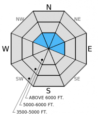
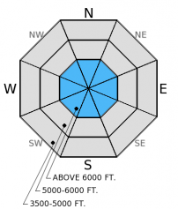
New snow over the past 24 hours combined with moderate winds created heightened avalanche conditions. The hazard above 5500 ft. is MODERATE and LOW below 5500 ft. Wind slabs likely formed yesterday and it will be possible to trigger a wind slab today. Storm slabs are also a concern as snow continues through tonight. Carefully evaluate how this new snow bonds to the old snow. The hazard could rise higher as more snow accumulates over the next 24 hours.

2. Moderate
?
Above 6500 ft.
2. Moderate
?
5000-6500 ft.
1. Low
?
3500-5000 ft.
- 1. Low
- 2. Moderate
- 3. Considerable
- 4. High
- 5. Extreme
-
Type ?
-
Aspect/Elevation ?

-
Likelihood ?CertainVery LikelyLikelyPossible
 Unlikely
 -
Size ?HistoricVery LargeLargeSmall

Moderate winds (17-25 mph) with strong gusts (26-40 mph) yesterday afternoon likely created wind slabs above 6000 feet. Winds are expected to increase this afternoon into tomorrow allowing for wind slab formation to continue. These wind slabs may be sensitive to human triggering today and could be over a foot thick in some places, particularly the northern Whitefish Range. Look for wind slabs on lee aspects of ridgelines or cross-loaded gullies. A quick hasty pit or stability test will allow you to determine the reactivity/sensitivity of these slabs.
-
Type ?
-
Aspect/Elevation ?

-
Likelihood ?CertainVery LikelyLikelyPossible
 Unlikely
 -
Size ?HistoricVery LargeLargeSmall

Snow is expected to continue to accumulate today into tonight. The Whitefish Range appears to be favored thus far in these successive rounds of precipitation (about 4 inches in the southern part and 7 inches in the northern end). The new snow should bond well to the underlying old snow, but a bit more snow today combined with a human trigger could be enough to tip the balance toward instability. Carefully assess how the new snow bonds to the old snow before moving into steeper terrain.
Additional concerns: Spring can bring a mixed bag of weather and avalanche conditions. On any given day the avalanche problems may range from new snow concerns to wet avalanche hazards or both. It is important to pay attention to these changing conditions. When the temperature fluctuates quickly above and below the freezing mark as it does for most of the spring conditions and hazard can change rapidly. Precipitation amounts are also a bit more tricky to forecast in the spring. If more snow falls than expected today, then the hazard could rise higher than forecasted.
It is also that time of year when cornices become a regular concern. Warmy, sunny days or warm temps and rain can weaken these behemoths. Give them a wide berth when traveling along ridges and avoid traveling on the slope underneath them.
The next regularly scheduled advisory will be issued Thursday, March 26. Our final advisory of the season is scheduled for Sunday, April 5.
Yesterday we rode into Hay Creek in the northern Whitefish Range. Access to upper elevation terrain is indeed becoming more difficult as rain and warm temperatures continue to eat away at the meager low elevation snowpack. We found about 4 inches (by mid-afternoon) of new snow that appeared to be bonding well to the underlying snow. The wind had not increased until later in the day so we did not observe any wind slabs, but since then winds increased so I suspect wind slabs formed near ridges. Below the new snow a series of crusts and old storm snow from the past two weeks exists and that was largely unreactive in our stability tests. We received no other observations since last Thursday.
A cold air mass north of the border brings cooler temperatures and continued snow through tonight. As of 4:00 a.m. temperatures above 6000 feet range from 24º-30º F with winds moving out of the southwest at 3-5 mph with gusts to 10 mph. In the past 24 hours new precipitation totals are:
Whitefish Range 4-7 inches of new snow (0.5-0.8 inches snow water equivalent)
Swan Range 4 inches (0.7 inches snow water equivalent)
Flathead Range and Glacier NP 1-3 inches (0.5 inches snow water equivalent)
Today, expect about 1-4 inches of more snow (snow levels around 4000 feet) with winds out of the southwest at 5-10 with gusts to 20 mph and temperatures in the upper 20s to mid-30s F.
| 0600 temperature: | 24-30 deg. F. |
| Max. temperature in the last 24 hours: | 31-38 deg. F. |
| Average wind direction during the last 24 hours: | Southwest |
| Average wind speed during the last 24 hours: | 3-19 mph |
| Maximum wind gust in the last 24 hours: | 19-40 mph |
| New snowfall in the last 24 hours: | 1-6 inches |
| Total snow depth: | 59-98 inches |
This advisory applies only to backcountry areas outside established ski area boundaries. This advisory describes general avalanche conditions and local variations always occur. This advisory expires at midnight on the posted day unless otherwise noted. The information in this advisory is provided by the USDA Forest Service who is solely responsible for its content.


