| Thursday | Thursday Night | Friday | |
|---|---|---|---|
| Cloud Cover: | Sunny and warming. | Clear. | Sunny with even warmer temperatures. |
| Temperatures: | 33-42 deg. F. | 18-27 deg. F. | 36-46 deg. F. |
| Wind Direction: | Southwest | Southwest | Southwest |
| Wind Speed: | 9-13 mph with gusts to 31 mph. | 7-12 mph with gusts to 30 mph. | 7-11 mph with gusts to 25 mph. |
| Snowfall: | 0 in. | 0 in. | 0 in. |
| Snow Line: |
Whitefish Range
Swan Range
Flathead Range and Glacier National Park
How to read the forecast
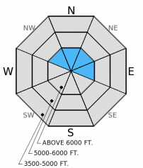
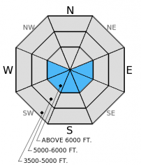
The hazard is MODERATE on wind loaded terrain and on sunny aspects. All other terrain has a LOW hazard. Moderate winds switched back to the southwest and began loading leeward slopes yesterday. Wind slabs exist near ridges. Also, abundant sunshine and above freezing temperatures will create a wet snow hazard on sunny aspects as the day progresses. Evaluate wind loaded slopes carefully and avoid sunny aspects by this afternoon.

2. Moderate
?
Above 6500 ft.
1. Low
?
5000-6500 ft.
1. Low
?
3500-5000 ft.
- 1. Low
- 2. Moderate
- 3. Considerable
- 4. High
- 5. Extreme
-
Type ?
-
Aspect/Elevation ?

-
Likelihood ?CertainVery LikelyLikelyPossible
 Unlikely
 -
Size ?HistoricVery LargeLargeSmall

Winds switched back to the typical southwest direction from the east yesterday. Thus, fresh and potentially sensitive wind slabs exist on leeward aspects and lingering wind slabs may still exist on windward aspects today. These wind slabs formed on top of the mid-February crust with weak snow (facets) above and below the crust. Some slabs could be over 2 feet thick. Cracking (photo) and collapsing are obvious signs of instability. Wind slabs will be located near ridges today, but could still exist mid-slope on cross-loaded features like gullies. Evalute wind loaded terrain carefully and watch for convex rollovers of wind drifted snow.
-
Type ?
-
Aspect/Elevation ?

-
Likelihood ?CertainVery LikelyLikelyPossible
 Unlikely
 -
Size ?HistoricVery LargeLargeSmall

Temperatures are expected to rise above freezing today and, with abundant sunshine, we could begin to see wet loose avalanches by the end of the day. In some locations a foot or more of snow from the past two weeks sits atop a crust from mid-February. This crust provides a great bed surface for loose snow avalanches. Both human triggered and natural wet loose avalanches are possible. However, this problem is very manageable by avoiding sunny slopes and moving to shadier terrain as the day progresses. Rollerballs and pinwheels are a good sign the surface snow is becoming wet and unstable.
The surface hoar/facets above the late January crust (the persistent slab problem) has been taken off of the problem list. We have not observed or received reports of an avalanche on this layer in nearly a month. This does not mean it is not a concern. Triggering an avalanche on this layer is unlikely, but not impossible. This layer still exists in spotty locations throughout the advisory area, and still fractures and propagates in isolated locations. It is still important to dig into the snowpack and identify this layer about 2-2.5 feet deep and perform a stability test like the extended column test to determine its reactivity. Avoid steep, rocky areas with a shallow snowpack where you are more likely to trigger an avalanche on this layer.
The next regularly scheduled advisory will be issued Saturday, March 7, 2015.
There are a few spots left in the Avalanche Skills Course: Choosing Terrain this Saturday. Check here for details and to register. The class is free.
Yesterday we observed wind slabs on many aspects due to these shifting winds in the Marion Lake and Essex drainages in the Flathead Range (photo1, photo2). Fresh wind slabs were beginning to form (photo) and were about 6-10 inches thick yesterday. They also fractured and propagated in our stability tests with easy force (ECTP 4).
We observed weak snow (facets) above and below the mid-February crust. Up to a foot (more on wind loaded slopes) of snow over the past two weeks sits atop this crust. It fractured in most tests, but did not propagate. However, it has propagated in other locations within the past week on wind loaded slopes where the slab is more cohesive (video).
The facets and/or surface hoar above the late January crust continue to show variable results in stability tests and this layer is becoming more isolated (rather than spotty) in nature. We observed no reactivity in our snowpits yesterday on this layer, but others in the Flathead Range did last weekend (observation).
High pressure moves into the area for a few days bringing clear skies and increasing temperatures. As of 4:00 a.m. temperatures above 6000 feet range from 7º-18º F with winds moving out of the southwest at 7-20 mph with gusts to 16-30 mph. Temperatures will begin chilly this morning, but rise to the mid to upper 30s F at the upper elevations today. Winds will move out of the southwest at 9-16 mph with gusts up to 30 mph, and even gustier near the Continental Divide (up to 40 mph).
| 0600 temperature: | 7-18 deg. F. |
| Max. temperature in the last 24 hours: | 16-26 deg. F. |
| Average wind direction during the last 24 hours: | Southwest |
| Average wind speed during the last 24 hours: | 5-11 mph |
| Maximum wind gust in the last 24 hours: | 9-30 mph |
| New snowfall in the last 24 hours: | 0 inches |
| Total snow depth: | 64-91 inches |
This advisory applies only to backcountry areas outside established ski area boundaries. This advisory describes general avalanche conditions and local variations always occur. This advisory expires at midnight on the posted day unless otherwise noted. The information in this advisory is provided by the USDA Forest Service who is solely responsible for its content.


