| Saturday | Saturday Night | Sunday | |
|---|---|---|---|
| Cloud Cover: | Mostly/partly cloudy | Clearing and cold | Mostly sunny and cold |
| Temperatures: | 14-26 deg. F. | -9-8 deg. F. | 22-34 deg. F. |
| Wind Direction: | NE | NE/E | E/SE |
| Wind Speed: | 10-15 gusts 35 | 8-10 gusts 25 | 3-4 |
| Snowfall: | 0-2 in. | 0 in. | 0 in. |
| Snow Line: |
Swan Range
Flathead Range and Glacier National Park
How to read the forecast
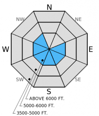
The hazard above 6000 feet is CONSIDERABLE on wind loaded slopes steeper than 35 degrees and MODERATE in other terrain above 5000 feet. 6-8 inches of new snow fell over the past 24 hrs in the Swan and Flathead Ranges. Winds shifted out of the north and loaded slopes that are usually windward. Avoid steep, windloaded terrain and assess the snow pack for near surface instabilities before committing to a slope.

3. Considerable
?
Above 6500 ft.
2. Moderate
?
5000-6500 ft.
1. Low
?
3500-5000 ft.
- 1. Low
- 2. Moderate
- 3. Considerable
- 4. High
- 5. Extreme
-
Type ?
-
Aspect/Elevation ?

-
Likelihood ?CertainVery LikelyLikelyPossible
 Unlikely
 -
Size ?HistoricVery LargeLargeSmall

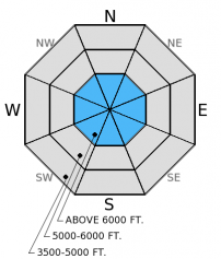
Winds shifted late yesterday out of the north/northeast and drifted new snow onto typically windward slopes. Fresh wind slabs 12-20 inches thick were deposited on firm crusts that will provide a good sliding surface. Be sure to check newly wind loaded slopes for the depth and reactivity of wind slabs and avoid terrain steeper than 35º that was recently wind loaded. Keep in mind the potential to encounter wind slabs at mid-elevations due to cross loading.
-
Type ?
-
Aspect/Elevation ?

-
Likelihood ?CertainVery LikelyLikelyPossible
 Unlikely
 -
Size ?HistoricVery LargeLargeSmall

Surface hoar formed in late January seems to be most prevalent in the Whitefish Range. There have not been any reported avalanches associated with this layer in quite some time, but it's well preserved presence is still a concern. Continue to seek out this weak layer and check the reactivity before venturing onto a slope. The likelihood of triggering an avalanche on this layer is becoming less, but the consequence remains high. Where present and reactive, steer clear of steep terrain, convex roll-overs, and shallow rocky areas. Weak snow formed around a series of recent rain/melt-freeze crusts have been observed across the area in the form of graupel, near surface facets, and shallowly buried surface hoar. These layers have produced variable results in stability tests, but should be evaluated as new snow piles up on top of them.
With a bit of new, cold, dry snow on top of a good sliding surface, be aware of the potential to trigger small, loose dry avalanches (sluffs). These avalanches are fairly easy to manage by staying above the sliding snow. But if you get caught off guard, they can pack a big punch, particularly if traveling in consequencial terrrain and around terrain traps.
Though variable in reactivity, most of the advisory area is pretty consistent in terms of the presence of weak snow in the top 1-1.5 feet of the snow pack. In the past week we observed near surface facets, graupel, and small surface hoar within the top foot of the snow pack in the Swan and Flathead Ranges (video). Skiers in Glacier Park on Wednesday also found weak snow in the upper snow pack that propagated fractures with moderate to hard force (observation).
On Thursday, skiers in the southern Whitefish Range found well preserved surface hoar buried 16 inches deep (observation, photo)
Temperatures began to fall yesterday as cold arctic air moved into the area. In the past 24 hours we received between 2-7 inches of new snow (.15-0.9 inches snow water equivalent), the most of which fell over the Swan and Flathead Ranges. Currently, mountain temperatures range from 8º-20º F and winds are out the north at 5-10 mph. For today, winds will blow out of the north/northeast and increase in speed to 15-20 mph with gusts in the 30s. Temperatures are expected in the mid-teens to low-20s and we could see a few isolated light snow showers.
| 0600 temperature: | 8-20 deg. F. |
| Max. temperature in the last 24 hours: | 25-32 deg. F. |
| Average wind direction during the last 24 hours: | SW-N/NE |
| Average wind speed during the last 24 hours: | 5-10 mph |
| Maximum wind gust in the last 24 hours: | 15-20 mph |
| New snowfall in the last 24 hours: | 2-7 inches |
| Total snow depth: | 66-94 inches |
This advisory applies only to backcountry areas outside established ski area boundaries. This advisory describes general avalanche conditions and local variations always occur. This advisory expires at midnight on the posted day unless otherwise noted. The information in this advisory is provided by the USDA Forest Service who is solely responsible for its content.


