| Sunday | Sunday Night | Monday | |
|---|---|---|---|
| Cloud Cover: | Partly/mostly cloudy, cooler temperatures | Mostly cloudy, light snow showers | Partly cloudy, continued cooling |
| Temperatures: | 32-42 deg. F. | 18-25 deg. F. | 28-34 deg. F. |
| Wind Direction: | W/NW | N | NE |
| Wind Speed: | 3-5 | 3-4 | 4-5 |
| Snowfall: | 0-1 in. | 0-1 in. | 0 in. |
| Snow Line: |
Whitefish Range
Swan Range
Flathead Range and Glacier National Park
How to read the forecast
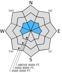
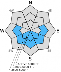
The avalanche hazard is MODERATE in steep terrain above 5500 feet. Human triggered avalanches are possible in isolated areas where buried surface hoar survived the recent series of warm, wet storm systems. Dig into the snow to determine if this weak layer is present, and where it is choose conservative, low angle terrain. Below 5500 feet the hazard is LOW.

2. Moderate
?
Above 6500 ft.
2. Moderate
?
5000-6500 ft.
1. Low
?
3500-5000 ft.
- 1. Low
- 2. Moderate
- 3. Considerable
- 4. High
- 5. Extreme
-
Type ?
-
Aspect/Elevation ?

-
Likelihood ?CertainVery LikelyLikelyPossible
 Unlikely
 -
Size ?HistoricVery LargeLargeSmall

In isolated areas a layer of surface hoar formed in late January remains preserved 1-2 feet deep in the snow pack. Numerous natural avalanches failed on this layer last weekend. In most locations this surface hoar has since rounded and strengthened, or was destroyed by a series of warm, wet weather systems. There is a lot of uncertainty in the distribution of this layer, so all slopes, particularly more shaded and sheltered areas should be treated as suspect. A quick snowpit should reveal an obvious stripe of weak snow above the thick late January crust (photo). Please let us know where you find it (or dont find it). Where it is present, stick to low angle slopes and avoid convex roll-overs and shallow, rocky terrain.
-
Type ?
-
Aspect/Elevation ?

-
Likelihood ?CertainVery LikelyLikelyPossible
 Unlikely
 -
Size ?HistoricVery LargeLargeSmall

In extended periods of sun exposure, be aware of the increased potential for loose, wet avalanches on sunny slopes. If you notice the surface becoming wet and roller balls form on steep slopes its time to move to a more shaded aspect.
Its felt a lot like Spring while navigating the brush and melted out roads at low elevations in the Flathead Range yesterday. We had a good view of several crowns from large upper-elevation avalanches that likely occured last weekend and failed on the weak layer that we were searching for yesterday. In the Pinnacle Creek drainage we found remnants of the late January surface hoar, but was mostly decomposed and failed with out propagation in only one of our extended column tests.
On Friday we found a preserved layer of surface hoar in the Whitefish Range that was reactive in stability tests (photo, video).
Overnight, a few of our weather stations recorded their first below freezing temperatures in over a week. The north part of the advisory area received up to 2 inches of snow in the past 24 hours. Currently, mountain temperatures range from 22º-31º F and winds are blowing out of the west and southwest at 5-7 mph. Today should see partly cloudy skies with cooler temperatures and winds blowing out of the west at 5-10 mph. We may see a few light snow showers today especially along the Continental Divide.
| 0600 temperature: | 22-31 deg. F. |
| Max. temperature in the last 24 hours: | 40-32 deg. F. |
| Average wind direction during the last 24 hours: | SW |
| Average wind speed during the last 24 hours: | 5-15 mph |
| Maximum wind gust in the last 24 hours: | 15-30 mph |
| New snowfall in the last 24 hours: | 0-2 inches |
| Total snow depth: | 60-89 inches |
This advisory applies only to backcountry areas outside established ski area boundaries. This advisory describes general avalanche conditions and local variations always occur. This advisory expires at midnight on the posted day unless otherwise noted. The information in this advisory is provided by the USDA Forest Service who is solely responsible for its content.


