| Monday | Monday Night | Tuesday | |
|---|---|---|---|
| Cloud Cover: | Sunny and warm. | Clear and warm. | Mostly clear and warm. |
| Temperatures: | 41-55 deg. F. | 29-39 deg. F. | 38-48 deg. F. |
| Wind Direction: | Southwest | Southwest | Southwest |
| Wind Speed: | 10-15 mph with gusts to 30 mph. | 10-15 mph with gusts to 30 mph. | 5-10 mph with gusts to 23 mph. |
| Snowfall: | 0 in. | 0 in. | 0 in. |
| Snow Line: |
Whitefish Range
Swan Range
Flathead Range and Glacier National Park
How to read the forecast
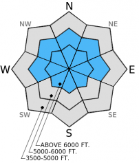
Unscheduled Update: Unstable conditions exist on sunny slopes. Temperatures will rise well above freezing and natural and human triggered loose, wet avalanches are likely today. Deeper, persistent slab avalanches are also possible. For today, the hazard is rated CONSIDERABLE above 5000 feet. Avoid slopes with sun exposure and avoid being under this terrain. Choose low angle, shady terrain and assess the snow pack for deeper instabilities which could be triggered by loose, wet avalanches.

3. Considerable
?
Above 6500 ft.
3. Considerable
?
5000-6500 ft.
2. Moderate
?
3500-5000 ft.
- 1. Low
- 2. Moderate
- 3. Considerable
- 4. High
- 5. Extreme
-
Type ?
-
Aspect/Elevation ?
-
Likelihood ?CertainVery LikelyLikelyPossible
 Unlikely
 -
Size ?HistoricVery LargeLargeSmall

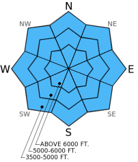
With most mountain locations remaining well above freezing the snow surface will start off wet before we reach the warmest part of the day. Natural loose, wet avalanches were reported in multiple locations yesterday and are likely again today. Roller balls, deep ski or boot penetration, pinwheels, or slushy surface snow are indicators that it's time to move to shadier slopes. Avoid being on or under these sunny slopes as soon as the sun hits. Keep in mind that even small avalanches can be dangerous in exposed terrain like cliff bands and terrain traps like gullies, creek beds, or roads.
-
Type ?
-
Aspect/Elevation ?
-
Likelihood ?CertainVery LikelyLikelyPossible
 Unlikely
 -
Size ?HistoricVery LargeLargeSmall

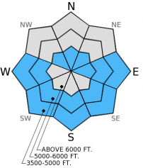
We have still not written off the weak snow near the mid-December crust. Though deeply buried (3-4 feet) and difficult to trigger, we have observed isolated areas where it is still propagates fractures in stability tests. In most locations in the advisory area there is another layer of surface hoar buried 1-1.5 feet deep. This layer has produced variable results in stability tests, but should be treated with caution. Smaller loose, wet avalanches have the potential to step down and trigger a deeper persistent slab. Dig into the snow to look for these layers and keep the slope angle below 35 degrees where these layers exist.
Warm temperatures and ample sunshine are producing free water in the upper part of the snowpack. As this water moves through the snowpack it could begin to affect these weak layers to the point where we could actually see wet slab avalanches on these deeper persistent weak layers. The travel advice remains the same: avoid sunny slopes and stay out from under steep, sunny terrain as well.
-
Type ?
-
Aspect/Elevation ?
-
Likelihood ?CertainVery LikelyLikelyPossible
 Unlikely
 -
Size ?HistoricVery LargeLargeSmall

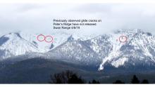
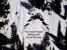
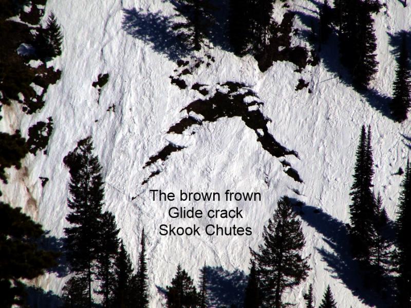
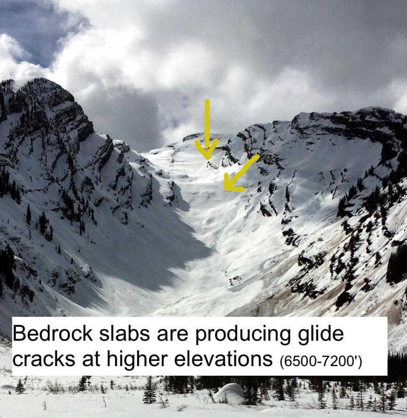
There were reports of glide avalanches in the Swan Range within the past week. A few more glide cracks were also observed. With unseasonably warm weather we may start to see more cracks opening. Glide cracks are notoriously difficult to preditct and it is best to simply avoid slopes where these cracks have formed.
A rapid warm up like this is like a gut punch to the snowpack. Unusual weather conditions breed unusual avalanche conditions. Upper elevation temperatures potentially reaching potentially over 50º F in the mountains in January certainly qualifies as unusual weather. With such warm mountain temperatures expected today, I would keep a conservative approach to terrain selection by avoiding all sunny slopes. Large cornices could also become sensitive as temperatures rise in the upper elevations, particularly if exposed to the sun for prolonged periods. Avoid traveling below large cornices and give them a wide margin of safety when traveling above them as they can break behind the ridgeline farther back than expected.
There were numerous reports of loose, wet avalanches on sunny slopes throughout the advisory area. These avalanches were up to size D2, but mostly in the D1 range. See the Observation page for more details and photos. One such loose, wet slide knocked a snowmobiler off of her machine and carried her a short distance as she was traversing across a slope. She was uninjured.
A slab avalanche in the Picture Chutes in Hellroaring Basin at the Whitefish Mountain Resort released yesterday afternoon in steep, rocky terrain. It was likely human triggered, but may have been triggered by a loose, wet avalanche. No one was reported caught. We are headed that way today to investigate the avalanche.
Remember, CONSIDERABLE hazard means human triggered small avalanches in many locations are likely and dangerous avalanche conditions exist on suny slopes. Some of these loose, wet slides can be large enough to bury, injure, or kill a person. Fortunately, loose, wet avalanche problems are easy to manage. Avoid being on or under sunny slopes particularly later in the day.


Loose, wet debris on Werner Peak, Whitefish Range. 1/25/2015. Photo: Guy Zoellner Loose, wet avalanches near Marion Lake. 1/25/2015. Photo: Zachary Miller.
Skies cleared and there was abundant sunshine yesterday afternoon with above freezing temperatures in the mountains. Currently, mountain temperatures are 25º-39º F and winds remain out of the southwest 8-13 mph with gusts to 27 mph. For today, expect more sunshine and even warmer temperatures in the mountains than yesterday. Some locations above 6000 ft. could reach 50 degrees. Winds will be 10-15 mph out of the southwest with gusts in the 30s F.
| 0600 temperature: | 25-43 deg. F. |
| Max. temperature in the last 24 hours: | 36-43 deg. F. |
| Average wind direction during the last 24 hours: | SW |
| Average wind speed during the last 24 hours: | 5-15 mph |
| Maximum wind gust in the last 24 hours: | 27 mph |
| New snowfall in the last 24 hours: | 0 inches |
| Total snow depth: | 56-90 inches |
This advisory applies only to backcountry areas outside established ski area boundaries. This advisory describes general avalanche conditions and local variations always occur. This advisory expires at midnight on the posted day unless otherwise noted. The information in this advisory is provided by the USDA Forest Service who is solely responsible for its content.


