| Monday | Monday Night | Tuesday | |
|---|---|---|---|
| Cloud Cover: | Snow. | Snow. | Snow. |
| Temperatures: | 17-26 deg. F. | 11-25 deg. F. | 20-32 deg. F. |
| Wind Direction: | West-Southwest | West-Southwest | West-Southwest |
| Wind Speed: | 10-20 mph with gusts to 40 mph. | 5-10 mph with gusts to 25 mph. | 10-20 mph with gusts to 30 mph. |
| Snowfall: | 6-20 in. | 4-9 in. | 6-9 in. |
| Snow Line: |
Whitefish Range
Swan Range
Flathead Range and Glacier National Park
How to read the forecast
An AVALANCHE WARNING is in effect for the entire advisory area. Substantial continued snowfall, moderate to strong winds, and rising temperatures created very dangerous avalanche conditions. All terrain in the advisory area is rated HIGH. Travel in avalanche terrain and runout zones is not recommended. Natural and human triggered storm and wind slabs are likely. Avalanches involving a persistent weak layer 2-5 feet deep are possible with this new, rapid load. Avalanches involving this layer could be large.

4. High
?
Above 6500 ft.
4. High
?
5000-6500 ft.
4. High
?
3500-5000 ft.
- 1. Low
- 2. Moderate
- 3. Considerable
- 4. High
- 5. Extreme
-
Type ?
-
Aspect/Elevation ?

-
Likelihood ?CertainVery LikelyLikelyPossible
 Unlikely
 -
Size ?HistoricVery LargeLargeSmall

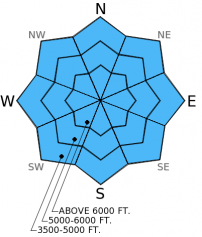
Substantial new snow that will continue through today and tonight has fallen on lighter snow and a potential weak layer (near surface facets). Rising temperatures overnight created more dense snow which the lighter snow underneath will be unable to support. We are uncertain of the distribution of near surface facets across the advisory area, but this layer could provide a weak layer for the new snow to fail on as well. Regardless, the amount of new snow and wind expected with this storm is enough to cause both natural and human triggered avalanches today. Travel in avalanche terrain is not recommended.
-
Type ?
-
Aspect/Elevation ?

-
Likelihood ?CertainVery LikelyLikelyPossible
 Unlikely
 -
Size ?HistoricVery LargeLargeSmall

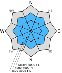
The weak layer of surface hoar and facets sitting on top of a melt-freeze crust from mid-December has shown signs of improvement over the last week. Most (but not all) recent stability tests show this layer unable to propagate fractures. However, this dragon may be awakened again with this new load. Though this weak layer is buried 2-4 feet deep and has become harder to trigger, new storm snow avalanches could step down into this weak layer. Avalanches that fail on this deep layer could be large and destructive. Today, avoiding avalanche terrain and runout zones and allowing the snowpack time to adjust to this new load is the best way to manage this problem.
This is an unscheduled, special avalanche warning. This warning will either be allowed to expire or updated by tomorrow morning at 7:00 am. The Flathead Avalanche Center issues regular advisories on Tuesday, Thursday, Saturday, and Sunday.
Prior to the onset of this storm we found a thin layer of weak snow near the surface (near surface facets) that formed last week (snow profile). This new snow will now create a slab on top of that potential weak layer. Yesterday, skiers in the Middle Fork corridor (Flathead Range) reported excellent skiing with some sloughing of the new snow. They found the persistent weak layer of surface hoar and facets above a melt-freeze crust unable to propagate fractures in their stability tests. Expect these avalanche conditions to change today with the snow and wind overnight continuing through today. With rising temperatures overnight, new snow has fallen on top of lighter snow. This lower density snow is not likely to support the newer more dense slab on top. The persistent weak layer that showed signs of improvement may become reactive again with this new load.
The well advertised storm slowly nudged its way in yesterday, but overnight it came in with a vengeance. This moist storm system with subtropical origins (read: wet) pushed out most of the cold air mass from the region leaving substantial snowfall, warming temperatures, and increasing winds. Temperatures as of 4:00 am range from 19º to 27º F with winds 5-15 mph gusting to 30 mph. Some mountain weather stations went from below zero to 28º F in the past 24 hours. Snow amounts overnight range from 6-14 inches with snow water equivalent (SWE) amounts from 0.7 to 1.8 inches. Note: Noisy Basin SNOTEL in the Swan Range reported 1.1 inches of SWE in just six hours overnight.
Expect snowfall to continue through today into tonight. Snow amounts are likely to range from 10-20 inches throughout the advisory area with increasing winds from the southwest at 10-20 mph and gusts to 40 mph.
| 0600 temperature: | 19-27 deg. F. |
| Max. temperature in the last 24 hours: | 19-27 deg. F. |
| Average wind direction during the last 24 hours: | South-Southwest |
| Average wind speed during the last 24 hours: | 5-15 mph |
| Maximum wind gust in the last 24 hours: | 27-29 mph |
| New snowfall in the last 24 hours: | 6-12 inches |
| Total snow depth: | 64-88 inches |
This advisory applies only to backcountry areas outside established ski area boundaries. This advisory describes general avalanche conditions and local variations always occur. This advisory expires at midnight on the posted day unless otherwise noted. The information in this advisory is provided by the USDA Forest Service who is solely responsible for its content.


