| Sunday | Sunday Night | Monday | |
|---|---|---|---|
| Cloud Cover: | Continued precipitation and warming | Mostly cloudy, snow showers taper. | Snow levels lowering, mostly cloudy. |
| Temperatures: | 33-39 deg. F. | 22-29 deg. F. | 26-32 deg. F. |
| Wind Direction: | West/Southwest | west | west |
| Wind Speed: | 18-22 gusts 44 | 11-16 gusts 29 | 9-13 |
| Snowfall: | 2-5 in. | 0-2 in. | 0-1 in. |
| Snow Line: |
Whitefish Range
Swan Range
Flathead Range and Glacier National Park
How to read the forecast
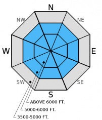
An AVALANCHE WARNING has been issued for all terrain above 6000 feet. Natural avalanche activity is likely above 6000 feet and remains possible below. New snow, warming, and wind continue to stress weak snow in the upper snow pack. Travel in avalanche terrain, run-out zones, and terrain traps is not recommended today.

4. High
?
Above 6500 ft.
3. Considerable
?
5000-6500 ft.
3. Considerable
?
3500-5000 ft.
- 1. Low
- 2. Moderate
- 3. Considerable
- 4. High
- 5. Extreme
-
Type ?
-
Aspect/Elevation ?

-
Likelihood ?CertainVery LikelyLikelyPossible
 Unlikely
 -
Size ?HistoricVery LargeLargeSmall

Overnight we received an additional load on a snow pack that lacked the strength to support its initial load. Snow will continue today accompanied by increasing wind intensity, and to further complicate the storm slab problem we are in a warming trend which will likely create an upside down storm layer. It is important to remember that fractures produced in surface hoar layers have the ability to propagate long distances and can move across aspect changes and around terrain features. It is recommended to avoid avalanche terrain today. If you do plan to travel in the backcountry choose low angle terrain and avoid large avalanche run-out zones.
-
Type ?
-
Aspect/Elevation ?

-
Likelihood ?CertainVery LikelyLikelyPossible
 Unlikely
 -
Size ?HistoricVery LargeLargeSmall

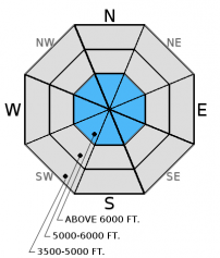
Observations of failed stability tests in weak snow near the ground are becoming scarce, and there has been no reported avalanche activity associated with this layer. In isolated areas we are still finding weak snow (facets) near the ground, mostly in areas with shallow snow. Continue to search for weak snow and avoid areas where you are most likely to trigger them like steep, rocky terrain with shallow snow.
Be aware of changing weather conditions today. The snow is expected to taper prior to temperatures climbing above freezing, however the potential for a rain on snow event does exist today. The snow pack does not like rapid change, and adding water in liquid form certainly qualifies as rapid change. If it begins to rain on the snow the wet snow avalanche hazard will rise at lower elevations.
This avalanche warning will be updated or allowed to expire by 7:00 a.m. on Monday, December 22, 2014.
Yesterday we were in the Marion Lake area in the Flathead Range. The snow pack was very thin below 5000 feet, we found that in this area the wind had more effect on the snow in the drainage bottom than along the ridgeline. There was 4-6 inches of recent cohesion less snow on top of a supportable melt-freeze crust. The isolated pockets of wind drifted snow that we traveled through did show signs of instability by cracking at our skis (photo). In the upper snow pack we found a melt-freeze crust formed last weekend almost a foot deep with a thin layer of weak (faceted) snow above. We also noted a layer of buried surface hoar about 4 inches deep. Even though there was no slab formation above these weak layers in this area, the evidence of recent wind and warming trend increases confidence that sensitive slabs exist near by.
Observations from the Whitefish Range tell a different story in regard to slab formation. WMR ski patrol conducted another avalanche control mission in the ski area yesterday and were able to trigger soft slab avalanches up to a foot deep (observation). Seth was adjacent to the ski area yesterday teaching an avalanche class, and found surface hoar buried almost a foot deep that was very reactive in stability tests. He was able to propagate a fracture in an extended column test with easy force on multiple aspects.
Skiers in Canyon Creek, also in the Whitefish Range reported natural avalanche activity yesterday (observation, Photos).
We received no other recent observations from the Swan Range or Flathead Range.
Yesterday, for most of the daylight hours temperatures remained cool, light snow showers dusted the area with up to an inch of new snow. Winds were out of the west and southwest 5-10 mph with gusts in the mid-20s. In the evening when temperatures should start to decline they headed in the opposite direction. As of 4:00 a.m. we picked up an additional 4-10 inches of snow across the advisory area. Mountain temperatures range from 24-31º F, and winds are 10-20 mph with gusts to 21 mph out of the southwest. For today, expect continued precipitation with rising temperatures and snow levels. Winds should shift out of the west and increase in intensity reaching sustained speeds in the high 20s with gusts in the 50s.
| 0600 temperature: | 24-31 deg. F. |
| Max. temperature in the last 24 hours: | 31 deg. F. |
| Average wind direction during the last 24 hours: | SW |
| Average wind speed during the last 24 hours: | 5-15 mph |
| Maximum wind gust in the last 24 hours: | 21 mph |
| New snowfall in the last 24 hours: | 4-10 inches |
| Total snow depth: | 45-55 inches |
This advisory applies only to backcountry areas outside established ski area boundaries. This advisory describes general avalanche conditions and local variations always occur. This advisory expires at midnight on the posted day unless otherwise noted. The information in this advisory is provided by the USDA Forest Service who is solely responsible for its content.


