| Thursday | Thursday Night | Friday | |
|---|---|---|---|
| Cloud Cover: | Cloudy with snow showers. | Cloudy with snow showers. | Cloudy with increasing snow showers. |
| Temperatures: | 29-36 deg. F. | 25-29 deg. F. | 30-36 deg. F. |
| Wind Direction: | Southwest | Southwest | Southwest |
| Wind Speed: | 5-10 mph with gusts to 20 mph. | 5-10 mph with gusts to 20 mph. | 5-15 mph with gusts to 25 mph. |
| Snowfall: | 1-2 in. | 1 in. | 1 in. |
| Snow Line: |
Whitefish Range
Swan Range
Flathead Range and Glacier National Park
How to read the forecast
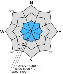
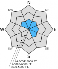
The avalanche hazard above 6000 feet is Moderate, but could rise to Considerable by later today with new snow and wind on the way. The hazard below 6000 feet is Low, but could rise to Moderate. Surface hoar and facets exist at and near the top of our snowpack. A substantial new snow load on top of these weak layers will cause the avalanche hazard to rise.

2. Moderate
?
Above 6500 ft.
1. Low
?
5000-6500 ft.
1. Low
?
3500-5000 ft.
- 1. Low
- 2. Moderate
- 3. Considerable
- 4. High
- 5. Extreme
-
Type ?
-
Aspect/Elevation ?

-
Likelihood ?CertainVery LikelyLikelyPossible
 Unlikely
 -
Size ?HistoricVery LargeLargeSmall

The weak snow near the ground throughout our advisory area continues to show signs of strengthening. However, in some locations, particularly areas with a shallow snowpack (typically three feet or less), this layer still shows signs of instability by propagating fractures in stability tests. Getting this layer to fracture and propagate in extended column tests is becoming increasingly more difficult, but the results cannot be ignored. Managing this problem is best done by avoiding steep slopes with a shallow snowpack. It's important to assess this layer on slopes you want to ski or ride. While obvious signs of instabilty (like cracking and collapsing) are lacking, this layer could become an issue again as new snow loads the snowpack in the coming days.
-
Type ?
-
Aspect/Elevation ?

-
Likelihood ?CertainVery LikelyLikelyPossible
 Unlikely
 -
Size ?HistoricVery LargeLargeSmall

A couple of skier parties reported isolated, thin wind slabs this week. A few inches of new snow with enough wind on top of surface hoar and facets near the surface could be enough to make wind slabs a problem later today.The melt-freeze crust from last week also provides a great bed surface for future slabs to slide on. Identifying wind loaded slopes and avoiding convex rollovers where wind slabs exist is a good way to mitigate this problem. Just digging down a foot or so into the snowpack and performing stability tests will help you assess the sensitivity of these wind slabs.
The next scheduled advisory will be issued Saturday, December 20, 2014.
Yesterday, Flathead Nordic Backcountry Patrol installed the beacon checkers at three locations near the Whitefish Mountain Resort ski area boundary. Thanks! This is a valuable resource and a great reminder to all who venture into the backcountry to carry your avalanche gear (beacon, shovel, and probe). Look for beacon checkers within the next week or so at other trailheads like Canyon Creek, Hungry Horse Dam, and Essex.
![]()
Beacon checker outside the ski area boundary near Flower Point.
We know that when we send the advisory via email that some folks are unable to see the hyperlinks in some email clients. We are working on our end to try and remedy this. Thanks for being patient.
Cold, clear nights with just a touch of wind earlier this week caused the development of surface hoar on most slopes. We found this surface hoar to be fairly large in the southern Whitefish Range yesterday (image). This layer was likely preserved overnight and now buried by just a bit of new snow. Since it's still close to the surface it would be wise to dig and investigate to see if this surface hoar layer exists on the slope you intend to ride or ski. A couple of other parties found this surface hoar layer on in Glacier National Park as well (observations).
The top 5-6 inches of the snowpack consists of a mix of this surface hoar, facets, and melt-freeze crusts from earlier this week (snow profile and image). It's important to monitor how these layers change and react with new snow over the next few days. Skiers in southern Glacier National Park found facets beneath the most recent melt-freeze crust (just 2-3 inches below the surface) to already propagate fractures in extended column tests.
Once again, the layer of weak snow (facets) near the ground continues to display variability across the advisory area. On some slopes this layer propagates fractures in our stability tests, and on other slopes it does not (video).
A weak disturbance today will replace the mild weather from the past 48 hours. Currently, mountain temperatures range from 24 to 29º F with winds out of the southwest at 5-20 mph. As of 4:00 a.m. mountain weather stations report around one inch of new snow. Today, expect snow to continue with winds out of the southwest at 10-15 mph with gusts into the 30 mph range near ridgetops. Snow amounts will vary across the ranges, but we could see up to 6 inches above 6000 feet. This pattern typically favors the Swan Range, but we will see what actually transpires.
| 0600 temperature: | 24-29 deg. F. |
| Max. temperature in the last 24 hours: | 25-31 deg. F. |
| Average wind direction during the last 24 hours: | Southwest |
| Average wind speed during the last 24 hours: | 8-10 mph |
| Maximum wind gust in the last 24 hours: | 10-22 mph |
| New snowfall in the last 24 hours: | 1 inches |
| Total snow depth: | 33-43 inches |
This advisory applies only to backcountry areas outside established ski area boundaries. This advisory describes general avalanche conditions and local variations always occur. This advisory expires at midnight on the posted day unless otherwise noted. The information in this advisory is provided by the USDA Forest Service who is solely responsible for its content.


