| Sunday | Sunday Night | Monday | |
|---|---|---|---|
| Cloud Cover: | Mostly cloudy with potential for a few lingering snow showers early. | Partly cloudy | Partly cloudy and slightly cooler. |
| Temperatures: | 29-33 deg. F. | 11-18 deg. F. | 27-29 deg. F. |
| Wind Direction: | east | east | southeast |
| Wind Speed: | 5 | 6 | 5 |
| Snowfall: | 0-1 in. | 0.0 in. | 0.0 in. |
| Snow Line: |
Swan Range
How to read the forecast
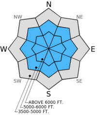
The Swan Range received a substantial amount of precipitation in the past 24 hours. As of 10:00pm last night Noisy Basin SNOTEL reported 8 inches of new snow with a snow water equivalent of 1.3 inches in the previous 24 hour period.In addition to stress added to previously formed weak layers, the storm snow needs time to settle and bond to the old snow surface. For today, avoid terrain steeper than 35º in areas that received this rapid load.

3. Considerable
?
Above 6500 ft.
3. Considerable
?
5000-6500 ft.
2. Moderate
?
3500-5000 ft.
- 1. Low
- 2. Moderate
- 3. Considerable
- 4. High
- 5. Extreme
-
Type ?
-
Aspect/Elevation ?

-
Likelihood ?CertainVery LikelyLikelyPossible
 Unlikely
 -
Size ?HistoricVery LargeLargeSmall

Yesterday and overnight the Swan Range received a substantial amount of new snow. In higher elevations this snow likely fell on top of a melt-freeze crust that would provide a good sliding surface for a storm snow avalanche. There is also the potential for weak snow like near surface facets to exist at the old snow and storm snow interface. Allow this new snow time to settle and adjust, avoid steep terrain in areas that received this rapid load.
-
Type ?
-
Aspect/Elevation ?

-
Likelihood ?CertainVery LikelyLikelyPossible
 Unlikely
 -
Size ?HistoricVery LargeLargeSmall

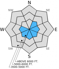
Winds associated with the frontal passage in the past 24 hours drifted new snow and formed new wind slabs on leeward slopes. In addition to the rapid stress a new wind slab exerts on the snow pack, these slabs formed on a melt-freeze crust that will provide a good sliding surface for a wind slab avalanche. There are likely areas where weak faceted snow exists at the new and old snow interface that will add to the instabilty of these new slabs. New snow combined with wind drifted snow adds a lot of weight to previously identified instabilities, it is possible for a relatively small wind slab avalanche to trigger a deeper avalanche. The best way to manage the wind slab problem today is to avoid wind loaded terrain.
-
Type ?
-
Aspect/Elevation ?

-
Likelihood ?CertainVery LikelyLikelyPossible
 Unlikely
 -
Size ?HistoricVery LargeLargeSmall

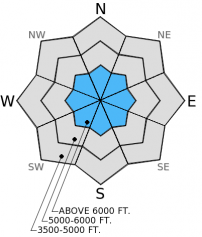
The most prominent form of persistent slab that we have observed recently is the weak, sugary snow near the ground. It has certainly gained strength over the past couple of weeks, but I still dont trust it. We have dug snow pits and found seemingly stable snow and just when confidence starts to build, the persistent slab will rear it's ugly head in another spot. These persistent slabs have been able to sit idle for over a week, and now in some areas more than others, they are being stressed. Continue to look for this weak snow and avoid areas where you are most likely to trigger an avalanche on it like areas with shallow snow and steep rocky terrain.
It is important to pay attention to changing conditions today. In areas that received a heavy load of unsettled new snow, be aware of prolonged breaks in the clouds that may warm the snow surface on sunny aspects. We could see loose, wet avalanche hazard increase at lower elevations with more sun than expected. Early signs that is time to move into a more shady area are when the snow surface becomes moist and you observe roller ball activity on steeper slopes.
Note: SNOTEL sites are down this morning. Current conditions below are based on data from remote weather stations in the Whitefish Range, Flathead Range, and southern Glacier National Park.
The next scheduled advisory will be Tuesday, December 16, 2014.
Yesterday we traveled into Canyon Creek and Skookoleel Ridge in the Whitefish Range. At mid-elevations where it was slower to cool below freezing the new snow fell on a moist snow surface and thin weak crust. Above 6500 feet the melt-freeze crust below the new snow was nearly supportable as temperatures had dropped before the onset of the precipitation. Along the ridge top a light northwest wind was drifting snow and forming thin wind slabs on the melt-freeze crust on leeward slopes. I expect that at higher elevations on less sheltered slopes more substantial wind slabs formed and could prove quite sensitive. We found what seems to be a further improving persistent slab problem yesterday in stability testing, but it remains important to see for yourself in the areas you are skiing or riding (video, photo)
Yesterday, the Swan Range picked up a lot more snow than expected, with 8 inches on the ground by 10:00 last night. More impressive than the snow total is the 1.3 inches of water weight added to the snow pack. Other locations received between 3 and 6 inches of new snow. Mountain temperatures dropped throughout the day and overnight. For today, expect temperatures to remain cool under mostly cloudy skys with north and east winds from 5-10 mph. There is the potential for a lingering snow shower this morning and ending late morning.
| 0600 temperature: | 19-22 deg. F. |
| Max. temperature in the last 24 hours: | 29-38 deg. F. |
| Average wind direction during the last 24 hours: | SW |
| Average wind speed during the last 24 hours: | 5 mph |
| Maximum wind gust in the last 24 hours: | 17 mph |
| New snowfall in the last 24 hours: | 3-8 inches |
| Total snow depth: | 40-42 inches |
This advisory applies only to backcountry areas outside established ski area boundaries. This advisory describes general avalanche conditions and local variations always occur. This advisory expires at midnight on the posted day unless otherwise noted. The information in this advisory is provided by the USDA Forest Service who is solely responsible for its content.


