| Saturday | Saturday Night | Sunday | |
|---|---|---|---|
| Cloud Cover: | Mostly Cloudy | Mostly Cloudy | Mostly Cloudy |
| Temperatures: | 25 to 31 deg. F. | 21 to 25 deg. F. | 29 to 34 deg. F. |
| Wind Direction: | Southwest | Southwest | Southwest |
| Wind Speed: | 27G59 | 38G63 | 45G71 |
| Snowfall: | 1" in. | 4" to 5" in. | 2" to 3" in. |
| Snow Line: | 3500' | 3500' | 4000' |
Whitefish Range
Swan Range
Flathead Range and Glacier National Park
How to read the forecast
The avalanche danger is rising as strong, gusty winds drift recent snow into dense slabs. You can easily trigger avalanches 1 to 3 feet deep on steep slopes with fresh deposits of drifted snow. Stick to sheltered terrain or low-angled slopes that aren't below ridges where you see blowing snow. In this terrain, riding slopes less than 35 degrees also reduces your risk of triggering slides that break on old snow. Potent storms may create dangerous conditions tomorrow and Monday.

3. Considerable
?
Above 6500 ft.
2. Moderate
?
5000-6500 ft.
1. Low
?
3500-5000 ft.
- 1. Low
- 2. Moderate
- 3. Considerable
- 4. High
- 5. Extreme
-
Type ?
-
Aspect/Elevation ?

-
Likelihood ?CertainVery LikelyLikelyPossible
 Unlikely
 -
Size ?HistoricVery LargeLargeSmall

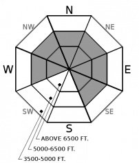
Loose snow at the snowpack surface plus strong, gusty winds: a recipe for drifting snow into unstable slabs on leeward and cross-loaded terrain. These will be more widespread near ridges and summits, though you can find them downwind of prominent terrain features and in gullies at mid-elevations as well. With strong winds forecast for today, they'll continue building. They'll be thickest near the crest of the Flathead Range and on the higher peaks around Lake McDonald. Expect a range of hardnesses, from slightly stiffened surface snow to firm, drum-like shells. They can break above you, particularly where it's difficult to edge your board or sleds, so it's best to avoid them altogether. Pay close attention to near-surface snow conditions and back out of steep terrain where the snow around your feet or machine doesn't feel loose and soft.
-
Type ?
-
Aspect/Elevation ?

-
Likelihood ?CertainVery LikelyLikelyPossible
 Unlikely
 -
Size ?HistoricVery LargeLargeSmall

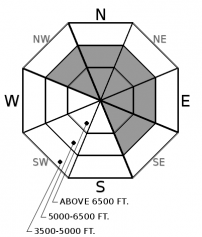
We've had reports of triggered avalanches each of the past 3 days. These are breaking 8 to 12 inches deep, mostly on weak, faceted snow above a crust buried 12/9. Shooting cracks have accompanied - announced - the slides, along with snowpack tests failing and propagating with easy force. The most regular reports of this instability have come from mid-elevation, easterly (NE-SE) slopes near Whitefish Mountain Resort. The structure is widespread enough, however, that it's worth sticking to slopes less than 35 degrees or assessing anything steeper at mid and upper elevations for terrain traps and the presence of this old, weak snow.
Friday's obs described a developing Wind Slab avalanche problem at mid and upper elevations. The signs included thick cornices breaking with a person's weight, blowing snow, and stiffening near-surface snow. Wind speeds increased overnight and are forecast to remain strong and gusty today. The hazard of triggering slabs of drifted snow is growing more widespread, with thicker and harder slabs forming. Yesterday I avoided steep (~32*) terrain above trees where I found these conditions. Today, I'd do the same, as well as staying out from under start zones with active wind loading - evident as blowing snow.
A rider reported triggering a slide large enough to bury a person on a steep, shaded, mid-elevation slope east of Whitefish Mountain Resort Friday. That's the third straight day with reported slide activity (Dec. 16, Dec. 17). These slides - and the shooting cracks that announce the hazard - are breaking on soft, faceted snow above a hard, icy crust that was buried Dec. 9. It's easy to identify if you dig into the snowpack, because it's marked by conifer needles. People have also reported snowpack tests propagating with easy force in the southern Whitefish Range, on the faceted snow above the Dec. 9 crust or at a thin rain crust or layer of surface hoar a few inches above the prominent crust. These slabs are getting harder to trigger where there's no drifted snow above them. I'd still be thinking twice about any shaded slope steeper than about 35 degrees, particularly one above a terrain trap. Either avoid this terrain or check for the presence and sensitivity of these old weak layers with an extended column test.
According to a character in a Cormac McCarthy novel, when a lamb cries, sometimes comes the mother. Sometimes comes the wolf. We've all been crying for more powder, and it's not clear yet if we're calling in a wolf. Models are forecasting warm, windy, wet storms tonight through Monday. It's not clear yet how high freezing levels will rise - probably over 6000 feet Monday - or how much snow and/ or rain will fall. Be prepared for dangerous avalanche conditions the next few days.
"Snowfall" might not be accurate today. The flakes in the atmosphere today will mostly be moving sideways, thanks to continued strong and gusty winds from the southwest. Temperatures will flirt with freezing at mid elevations today. Tonight and tomorrow bring more of each element - more snow, stronger winds, warmer temperatures.
This forecast applies only to backcountry areas outside established ski area boundaries. The forecast describes general avalanche conditions and local variations always occur. This forecast expires at midnight on the posted day unless otherwise noted. The information in this forecast is provided by the USDA Forest Service who is solely responsible for its content.


