| Sunday | Sunday Night | Monday | |
|---|---|---|---|
| Cloud Cover: | Mostly Cloudy | Mostly Cloudy | Mostly Cloudy |
| Temperatures: | 17 to 22 deg. F. | 14 to 17 deg. F. | 19 to 24 deg. F. |
| Wind Direction: | Southwest | Southwest | West |
| Wind Speed: | 10 | 12 | 11 |
| Snowfall: | 0" in. | 0 to 1" in. | 0" in. |
| Snow Line: | 500' | 1500' | 1500' |
Whitefish Range
Swan Range
Flathead Range and Glacier National Park
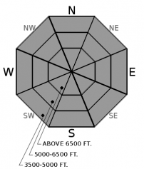
How to read the forecast
Avalanche hazards are small and isolated to steep, upper elevation terrain. Triggering a slide might, however, have serious consequences, because this terrain is chock full of consequence magnifiers: cliffs, rocks, trees and gullies where debris from small slides piles up deeply. Where you find about 8 inches or more of loose snow at the surface, beware of loose dry slides. Near ridgelines and summits, be alert for hard slabs of drifted snow sitting on loose, sugary snow.

1. Low
?
Above 6500 ft.
1. Low
?
5000-6500 ft.
1. Low
?
3500-5000 ft.
- 1. Low
- 2. Moderate
- 3. Considerable
- 4. High
- 5. Extreme
-
Type ?
-
Aspect/Elevation ?

-
Likelihood ?CertainVery LikelyLikelyPossible
 Unlikely
 -
Size ?HistoricVery LargeLargeSmall

While avalanche hazards are generally small and isolated, the nature of the hazards varies across the forecast region. Where you find loose snow at the surface, you can trigger sluffs of dry snow on slopes steeper than about 38 degrees. These can be dangerous where there's about 8 inches or more of cohesionless snow at the surface, conditions that exist primarily in the northern Whitefish Range. Near the crest of the Swan and Flathead Ranges, high points in the Whitefish Range, and the summits around Lake Mcdonald, you may be able to trigger hard slabs of drifted snow where they sit on soft, weak, sugary snow. Pockets of surface hoar may have survived this week's warming and wind in sheltered, mid-elevation, shaded slopes throughout the region. To avoid stumbling into one of these isolated hazards, assess each steep slope you plan to climb or ride for conditions and consequences. Alternatives abound, so move on if you have any questions about what you find.
Observations over the past week haven't included notable avalanche activity or evidence of persistent weak layers. Indeed, they've been remarkable for being unremarkable. Two parties have reported crowns from large avalanches on peaks near Lake McDonald, both on typically leeward slopes (here and here). I and another observer mentioned small sluffs in the northern Whitefish Range Saturday, though these posed little danger except in steep terrain with poor runouts. Cam reported a few more on Thursday in the Flathead Range. In the southern Whitefish Range, a few pockets of surface hoar appear to have survived last week's wind and warming, but there's currently little slab above this potential weak layer. With one exception, snowpack tests have not produced propagation. Even that exception wasn't duplicated in a second test at the same test.
It's fair to say, then, that avalanche hazards are currently small and isolated. They're dangerous where the terrain magnifies the consequences: steep, confined chutes, snowfields above rockbands, gullies, or trees. You can stay out of trouble by assessing individual slopes for conditions and consequences. Choose terrain with clean runouts to minimize consequences.
The primary hazard varies between the zones. Loose Dry avalanches are possible where you find 8 inches or so of loose, cohesionless snow. That's mostly confined to shaded slopes in the northern Whitefish Range, though you might find sluffs on southerly slopes run long and fast on an underlying crust. Wind Slabs sensitive to a person's weight may still exist near the crests of the Swan and Flathead Ranges and summits above Lake McDonald. Look for firm, wind-hardened snow above distinctly softer, sugary snow. Quick hand pits or probing with a pole can alert you to these conditions. Across the region, steep breakovers in sheltered, mid elevation terrain may harbor intact surface hoar that was buried midweek. Be alert for whumpfing collapses or shooting cracks.
If you find these conditions on a steep slope with a poor run out, move on. Alternatives abound.
A weak "storm" forecast for tonight isn't likely to affect conditons much.
Look for another day of mostly cloudy skies, light winds, and a trace to an inch of new snow.
This forecast applies only to backcountry areas outside established ski area boundaries. The forecast describes general avalanche conditions and local variations always occur. This forecast expires at midnight on the posted day unless otherwise noted. The information in this forecast is provided by the USDA Forest Service who is solely responsible for its content.


