| Saturday | Saturday Night | Sunday | |
|---|---|---|---|
| Cloud Cover: | Partly Cloudy | Mostly Cloudy | Mostly Cloudy |
| Temperatures: | 16 to 21 deg. F. | 11 to 14 deg. F. | 17 to 23 deg. F. |
| Wind Direction: | West | Southwest | South |
| Wind Speed: | 5 G 15 | 10 | 11 |
| Snowfall: | 0" in. | 0" in. | 0" in. |
| Snow Line: | 500' | 500' | 500' |
Flathead Range and Glacier National Park
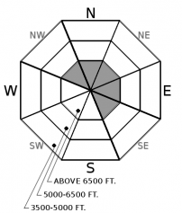
How to read the forecast
If your travels take you into the alpine, especially around the Lake McDonald area, watch for wind drifted slabs that can be large enough to bury or injure you. Recent avalanches, shooting cracks, and pillowy drifts are all signs to tone back your decisions and choose simpler terrain. You will most likely find these signs above 6500’ where more snow fell and winds drifted slabs over a weak snowpack structure

2. Moderate
?
Above 6500 ft.
1. Low
?
5000-6500 ft.
1. Low
?
3500-5000 ft.
- 1. Low
- 2. Moderate
- 3. Considerable
- 4. High
- 5. Extreme
-
Type ?
-
Aspect/Elevation ?

-
Likelihood ?CertainVery LikelyLikelyPossible
 Unlikely
 -
Size ?HistoricVery LargeLargeSmall

Stubborn wind slabs may still pose a threat in areas around central Glacier National Park and the northern Whitefish Range. A recent avalanche on Mt. Stanton in Glacier National Park is a friendly reminder to choose simpler terrain. Shooting cracks and pillowy looking drifts are both signs to seek out terrain that is sheltered from the wind. This is likely where you will find more enjoyable riding conditions.
Throughout most of the region expect low hazard conditions. Mountain snowfall accumulations reflect what you see out your window in the valley with little to no additional snow forecast today. If you head into the Swan, Flathead, southern half of the Whitefish Range and Glacier Park, you will likely be riding on a few inches of snow above a crust. Enjoy mostly stable avalanche conditions here with the only concern being a small sluff that can be triggered in steep terrain.
Now, if you decide to get into the northern half of the Whitefish Range, you may find yourself with 8 or more inches of new snow under your feet or machine. This new snow is sitting on a slick crust or possibly a persistent weak layer that was buried on the 9th. The major concern in this area is a firm wind slab over a persistent weak layer. These slabs can break in surprising ways and propagate long distances. Obvious signs of wind drifted snow should lead you into terrain that was protected from the wind. As mentioned above, mind your sluff if your decisions take you into larger terrain where a small avalanche can pick up steam and knock you off your feet.
Yesterday in the Lake McDonald area of Glacier National Park, Clancy found a large natural avalanche off the NE face of Stanton at about 7100’ (observation here). Above 6500’ he also found a weak snowpack with roughly 6 inches of new snow. Keep this observation in the back of your mind if your objective is to get into the alpine today. Look for recent avalanches and be in tune with what is going on below the surface. If you plunge your ski pole into the snow and it goes from firm to soft, tone back your decisions and choose something less consequential.
Expect a cool, calm day today. Temperatures will be in the high teens with light winds gusting to 15 mph at the highest ridgelines. Light snowfall is expected for the Swan Range with no accumulations expected in other areas of our forecast area.
This forecast applies only to backcountry areas outside established ski area boundaries. The forecast describes general avalanche conditions and local variations always occur. This forecast expires at midnight on the posted day unless otherwise noted. The information in this forecast is provided by the USDA Forest Service who is solely responsible for its content.


