| Tuesday | Tuesday Night | Wednesday | |
|---|---|---|---|
| Cloud Cover: | Mostly Cloudy | Mostly Cloudy | Mostly Cloudy |
| Temperatures: | 24 to 31 deg. F. | 14 to 20 deg. F. | 25 to 31 deg. F. |
| Wind Direction: | West | Southwest | West |
| Wind Speed: | 8 to 13, gusting to 20 | 5 to 10, gusting to 20 | 8 to 13, gusting to 20 |
| Snowfall: | 1" to 3" in. | T to 2" in. | 1" to 3" in. |
| Snow Line: | 2500' | 2500' | 2000' |
Flathead Range and Glacier National Park
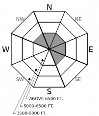
How to read the forecast
While conditions are generally stable, it's worth reading the fine print for the exceptions: isolated wind slabs at upper elevations. Look for and avoid these pockets, which can have exaggerated consequences in steep terrain.

1. Low
?
Above 6500 ft.
1. Low
?
5000-6500 ft.
1. Low
?
3500-5000 ft.
- 1. Low
- 2. Moderate
- 3. Considerable
- 4. High
- 5. Extreme
-
Type ?
-
Aspect/Elevation ?

-
Likelihood ?CertainVery LikelyLikelyPossible
 Unlikely
 -
Size ?HistoricVery LargeLargeSmall

Moderate to strong winds have drifted snow into slabs near the tops of chutes and couloirs, on the lee sides of gullies, and downwind of saddles and passes on ridges. These may grow and/ or become more widespread with a few inches of new snow and moderate winds today. The fresh snow may also hide surface textures that can make it straightforward to identify these visually. Be alert for snow underfoot or under your machine that feels hollow or unusually dense. Pick lines that don't funnel you and debris from these slabs over cliffs or into gullies and chutes.
Should you find yourself hitting the jackpot and riding in an area that's received 6 inches or more of new and recent snow, fine tune your avalanche radar. Moderate to strong sustained winds the past few days have drifted snow at upper elevations, creating isolated slabs that may be hidden under fresh snow. These will be more widespread and larger in the high peaks of the Flathead Range and Glacier National Park, where more loose snow has been available to blow around. Small, soft slabs may form today in the Swan and Whitefish Ranges if snowfall reaches or exceeds forecast totals in those ranges. Be alert for drifts and slabs as you approach ridgelines and summits.
Snow showers are forecast to continue tonight and tomorrow, and if new snow accumulations meet or exceed forecast totals, expect a rise in avalanche danger tomorrow.
Snow showers are likely today, with a few inches of fresh snow possible. The models are fickle about where's favored; output from different models suggests the northern Whitefish Range, the Continental Divide or the southern swath of the forecast region. Pretty much everywhere and anywhere. So long as it's not nowhere. Shower activity continues into tomorrow. Winds will be light to moderate from the southwest.
This forecast applies only to backcountry areas outside established ski area boundaries. The forecast describes general avalanche conditions and local variations always occur. This forecast expires at midnight on the posted day unless otherwise noted. The information in this forecast is provided by the USDA Forest Service who is solely responsible for its content.


