| Friday | Friday Night | Saturday | |
|---|---|---|---|
| Cloud Cover: | Mostly Cloudy | Mostly Cloudy | Mostly Cloudy |
| Temperatures: | 8 to 13 deg. F. | -11 to -7 deg. F. | -4 to 2 deg. F. |
| Wind Direction: | Northeast | Northeast | Northeast |
| Wind Speed: | 20 to 30, G45 | 25 to 35, G55 | 20 to 30, G45 |
| Snowfall: | 0 to 2" in. | 2" to 4" in. | 2" to 4" in. |
| Snow Line: | 0' | 0' | 0' |
Whitefish Range
Swan Range
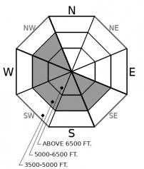
How to read the forecast
Northeast winds are expected to increase with today’s cold front. Be wary of fresh wind loading on atypical aspects and in unusual locations. Wash your hands of this developing threat by riding in terrain where the snow is soft and sheltered from wind.

2. Moderate
?
Above 6500 ft.
2. Moderate
?
5000-6500 ft.
1. Low
?
3500-5000 ft.
- 1. Low
- 2. Moderate
- 3. Considerable
- 4. High
- 5. Extreme
-
Type ?
-
Aspect/Elevation ?

-
Likelihood ?CertainVery LikelyLikelyPossible
 Unlikely
 -
Size ?HistoricVery LargeLargeSmall

Northeast winds are expected to increase today. Winds will drift snow into easily triggered slabs on southerly and westerly aspects, the opposite of where you normally find them. Blowing snow will be an easy way to spot the problem as it develops today. In steep terrain, avoid riding on lobes of dense, thicker snow formed by today's winds. Although these slabs may not entrain enough snow to bury you, they will certainly be thick enough to drag you into a tree or push you over rocks. You can avoid the problem by choosing terrain where the snow is sheltered or being scoured from wind.
Observers yesterday reported that the new snow is trending towards good stability. Expect conditions to change today as northeast winds rake the powdery snow off of northerly aspects and deposit fresh wind slabs onto crusty southwesterly aspects. Weather stations early this morning are showing light winds out of the north and northeast. Winds are expected to increase into the 30's by midday. Although the extent and severity of today's winds remain uncertain, developing wind slabs will be easy to spot. If you find yourself surrounded by calm air and soft, powdery snow, enjoy the stable riding conditions. If you find yourself getting battered by winds with snow blowing all around you, put on another jacket before you die from wind chill. Then, retreat to where the winds are quieter and calmer. Northeast wind events tend to form dense and thick drifts that don't span far across the terrain. If you are forced to pick your way through wind-affected terrain, look for, feel for, and avoid crossing dense pockets of new slabs. You'll find them littered behind trees and just downwind of ribs and other features. If the snow feels stiff and grabby, it has been drifted by wind.
You'll notice that we removed deep slabs from the problem list in the Flathead Range / GNP. This scary problem has been stuck in our forecast products all winter, but activity has tapered dramatically in the past month. Under the recent and current weather patterns, our limited evidence suggests that the faceted crusts near the ground are becoming dormant. This could change in the future with large loading events or from meltwater moving into the snowpack. Forecasting and assessing for deep slab instabilities is always a challenge, and our forecast team still holds some reservations and uncertainties. It's always good practice to reduce your exposure below alpine faces with cornices.
Fool's Spring is over. Second Winter has begun. An arctic cold front is pushing across NW Montana this morning, bringing frigid air and increasing northeast winds in its wake. The bulk of precipitation will stay contained east of the Continental Divide, with any spillover snowfall favoring the Park and Whitefish Ranges. The mercury just dropped below zero at Marias Pass early this morning, while the Swan Range remains relatively balmy in the 20's. Expect the cold air to continue to filter across the region through today and into tomorrow.
This forecast applies only to backcountry areas outside established ski area boundaries. The forecast describes general avalanche conditions and local variations always occur. This forecast expires at midnight on the posted day unless otherwise noted. The information in this forecast is provided by the USDA Forest Service who is solely responsible for its content.


