| Thursday | Thursday Night | Friday | |
|---|---|---|---|
| Cloud Cover: | Mostly Cloudy | Mostly Cloudy | Partly Cloudy |
| Temperatures: | 27 to 34 deg. F. | 21 to 26 deg. F. | 33 to 40 deg. F. |
| Wind Direction: | Southwest | Southwest | Southwest |
| Wind Speed: | 10 to 18, G35 | 10 to 18, G35 | 10 to 18, G35 |
| Snowfall: | 0" in. | 0" in. | 0" in. |
| Snow Line: | 3500' | 4000' | 4000' |
Flathead Range and Glacier National Park
How to read the forecast
Moderate winds over the past few days have continued to form slabs in wind loaded terrain. Use caution below leeward ridgelines and in cross-loaded terrain features. If the sun breaks through the clouds today, expect loose wet avalanches to release from steep slopes where the snow becomes moist.

2. Moderate
?
Above 6500 ft.
2. Moderate
?
5000-6500 ft.
1. Low
?
3500-5000 ft.
- 1. Low
- 2. Moderate
- 3. Considerable
- 4. High
- 5. Extreme
-
Type ?
-
Aspect/Elevation ?
-
Likelihood ?CertainVery LikelyLikelyPossible
 Unlikely
 -
Size ?HistoricVery LargeLargeSmall

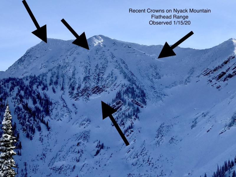
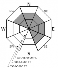
Observers over the past few days have reported continued slab development and wind slab avalanches from the Flathead Range and Glacier Park. Moderate west and southwesterly winds continue to drift recent snow into thicker, more cohesive slabs in leeward and cross-loaded terrain. Although these slabs are becoming more stubborn now, they might also be stiff enough to break above you drag you off your skis and machine if you trigger one. Monitor the snow surface for signs of wind transport and thicker drifts. If the snow feels or looks slabby, seek out more protected terrain.
-
Type ?
-
Aspect/Elevation ?
-
Likelihood ?CertainVery LikelyLikelyPossible
 Unlikely
 -
Size ?HistoricVery LargeLargeSmall

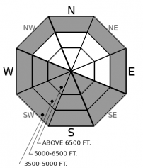
If we see periods of sunshine accompanying today's rising temperatures, watch for sluffs initiating from very steep or rocky terrain where the snow surface moistens. Rollerballs and pinwheels are precursors to avalanche activity. Although loose wet avalanches today are expected to be small, they can pack a punch if they push you into trees, over rocks, or into gullies. Move towards colder snow or lower angle terrain to avoid the problem.
-
Type ?
-
Aspect/Elevation ?
-
Likelihood ?CertainVery LikelyLikelyPossible
 Unlikely
 -
Size ?HistoricVery LargeLargeSmall

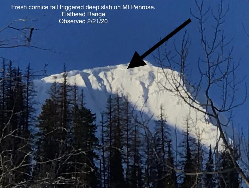
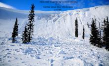
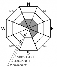
Cornice fall triggered a large avalanche on a northeast-facing slope near Mt. Penrose last Thursday or Friday. The slide is a good reminder of the lingering danger of large avalanches breaking on weak snow near the ground in high alpine bowls and faces in the Flathead Range and Glacier Park on northerly and easterly aspects. While these slides are unlikely, it's good policy to limit your time under steep northerly and easterly start zones near ridges, particularly those with large cornices. Temperatures are trending up over the next two days increasing the threat of cornice falls.
Surface hoar has been the buzz word in this week's forecasts. It is a tricky weak layer, notorious for catching even the most experienced pros off guard. In the Swan Range, the 2/23 surface hoar layer is buried 1 to 2 feet deep, in the Whitefish Range, about a foot or more. We have yet to find it buried in the Flathead Range, although there are probably isolated pockets. Our forecast staff has a poor handle on how widespread the layer is; it developed quickly, was destroyed by sun and strong winds in a lot of terrain, and was then quickly buried before we could properly map its distribution. On Tuesday, I found consistent feedback from it in Noisy Basin: any time we stepped off the skin track in wind protected, shady areas, we experienced collapses and shooting cracks. Yesterday, Clancy and I went looking for it at Stryker Ridge and couldn't find it. Cam has been consistently finding it in pits in the Southern Whitefish Range. We had numerous observations from the Flathead Range and John F Stevens Canyon reporting that the surface hoar got destroyed by Saturday's wind event. If anything, this should highlight the variability and uncertainty we have around our developing persistent slab problem. Our forecasts are highlighting it in the Whitefish and Swan Ranges, where we have had clear evidence of the problem. In the Flathead Range and Glacier Park, continued wind transport over the past few days has been driving the primary concern, and buried surface hoar appears to be an isolated issue. Fortunately, the surface hoar is buried shallow enough that we can still get fairly reliable feedback from it. Quick pits looking for a grey, feather stripe, or jumping around on small steep rollovers are useful for monitoring the problem. Don't rely on one piece of data though; be thorough and redundant in your assessments.
The powdery snow surface is primed for another round of loose wet avalanches. Tomorrow is a sure bet, with it's warm and sunny forecast. Today is a harder forecast. Temperatures will rise to near or just above freezing, but avalanche activity will hinge on whether the sun comes out. Weather models are disagreeing on how much cloud cover will linger. We are expecting enough sunshine by the end of the day to initiate some small loose wet slides. Tomorrow will bring larger and more widespread activity. Pay attention to changing surface conditions and cloud cover .
A high pressure ridge is transitioning towards NW Montana. Today we'll see temperatures rise a few degrees warmer than yesterday, and a mix of clouds with periods of sunshine. Tomorrow looks to be warm with lots of sun. A cold front on Saturday will bring snowfall back to the region.
This forecast applies only to backcountry areas outside established ski area boundaries. The forecast describes general avalanche conditions and local variations always occur. This forecast expires at midnight on the posted day unless otherwise noted. The information in this forecast is provided by the USDA Forest Service who is solely responsible for its content.


