| Saturday | Saturday Night | Sunday | |
|---|---|---|---|
| Cloud Cover: | Partly Cloudy | Mostly Cloudy | Mostly Cloudy |
| Temperatures: | 26 to 34 deg. F. | 17 to 21 deg. F. | 27 to 35 deg. F. |
| Wind Direction: | Southwest | Southwest | South |
| Wind Speed: | 15 to 20 gusting to 30 | 10 to 15, gusting to 20 | 10 to 15, gusting to 35 |
| Snowfall: | 0" in. | 0" in. | 3" to 5" in. |
| Snow Line: | 3000' | 3000' | 3000' |
Whitefish Range
Swan Range
How to read the forecast
Hard slabs of drifted snow may pose a hazard in the tops and sides of chutes and on large, open faces. Avoid this terrain if you find firm, polished and hollow sounding surface snow. Sluffs of heavy wet snow are possible on steep slopes where sustained sun is melting the surface snow. Both of these hazards are isolated. Don't dawdle under steep faces topped by overhanging cornices, especially those where you see snow swirling near ridges.

2. Moderate
?
Above 6500 ft.
2. Moderate
?
5000-6500 ft.
2. Moderate
?
3500-5000 ft.
- 1. Low
- 2. Moderate
- 3. Considerable
- 4. High
- 5. Extreme
-
Type ?
-
Aspect/Elevation ?

-
Likelihood ?CertainVery LikelyLikelyPossible
 Unlikely
 -
Size ?HistoricVery LargeLargeSmall

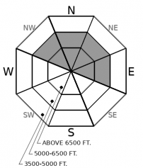
You can trigger avalanches of hard, drifted snow on steep slopes near ridges and in cross-loaded, open bowls and gullies well below ridges. These freshly-formed hard slabs are a few inches to a foot or more thick. Although they're isolated, they can be dangerous above features that magnify your chances of injury or deeper burials, like trees and gullies. Avoid steep start zones with dense, firm snow where your boards or machine can't sink in.
-
Type ?
-
Aspect/Elevation ?

-
Likelihood ?CertainVery LikelyLikelyPossible
 Unlikely
 -
Size ?HistoricVery LargeLargeSmall

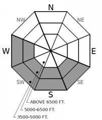
On very steep slopes - those near 40 degrees - that recieve sustained sun, triggered and natural wet loose avalanches may become possible this afternoon. They'll be most likely and entrain more debris where the snow is getting wet for the first time, like the steep, partly shaded walls of gullies at low and mid elevations. Natural and triggered rollerballs that fan down a slope are a reliable sign the surface snow is getting primed from wet snow avalanches. The sluffs of wet snow will be less likely and involve less debris in terrain that's been affected by the sun the past few days and refrozen crusts are slow to break down.
Observers in the Flathead Range reported moderate to strong winds at upper elevations Friday that drifted snow and created thin but hard wind slabs on leeward slopes and on open slopes at mid elevations. We had no reports from the Swan Range or the higher peaks in the Whitefish Range, though conditions were likely similar. We may see more drifting snow at upper elevations today, as winds should remain moderate to strong. Hard wind slabs give inconsistent feedback - sometimes cracking or releasing when weighted, sometimes doing neither. That makes slope-specific assessments necessary. The unpredictability also makes slope cuts a poor tool, because the slabs can allow a rider to get into the middle of a start zone before they break higher on the slope. Cornices remain hard and unpredictable; give them a wide berth on ridges and avoid dawdling below them.
Despite winds and cool temperatures, the sun pumped enough energy into the snowpack Friday to wet the snow surface on open slopes at low and mid elevations. Observers reported a few small natural and triggered wet loose sluffs, along with some larger slides that ran in the past few days. These didn't run far or entrain much snow. Existing crusts were slow to break down, and the snow was most sensitive to slope cuts on steep, due south slopes. The snow surface on many low and mid elevation slopes remained dry, however.
This morning's temperatures are 10 to 15 degrees warmer at low elevations than yesterday, and inversions have set up, with mid and upper elevation temperatures in the low 20s. With mostly sunny skies this morning, I expect temperatures to bounce to freezing sooner and in more locations today. The potential for natural and triggered wet loose avalanches continues. It will be highest on very steep slopes where the snow surface is getting wet for the first time. Clouds moving in later this afternoon should prevent this problem from becoming widespread.
A falling cornice near Mt. Penrose in the northern Flathead Range triggered a large natural avalanche sometime in the past two days. The slide broke deep in the snowpack and is a good reminder - along with two recent natural avalanches on the Rocky Mountain Front - of the low probability-high consequences Deep Slab avalanche problem that lingers in the highest terrain in the Flathead Range and Glacier National Park. Keep thyself out from under the terrain most likely to harbor these early season weak layers, especially where large cornices overhang start zones.
The ridge that's been parked overhead is breaking down, so the forecast region will see increasing clouds, mostly this afternoon, and continued moderate winds. Air temperatures should rebound quickly to near freezing at mid elevations, with upper elevations seeing slightly warmer temperatures today. A system late Sunday looks to bring some snow.
This forecast applies only to backcountry areas outside established ski area boundaries. The forecast describes general avalanche conditions and local variations always occur. This forecast expires at midnight on the posted day unless otherwise noted. The information in this forecast is provided by the USDA Forest Service who is solely responsible for its content.


