| Monday | Monday Night | Tuesday | |
|---|---|---|---|
| Cloud Cover: | Mostly cloudy | Mostly cloudy | Mostly Cloudy |
| Temperatures: | 20 to 26 deg. F. | 10 to 14 deg. F. | 22 to 28 deg. F. |
| Wind Direction: | Northwest | Southwest | Southwest |
| Wind Speed: | 0 to 10 | 5 to 15, G30 | 10 to 20, G35 |
| Snowfall: | 0" -1" in. | 0" in. | 1" to 3" in. |
| Snow Line: | 0' | 500' | 500' |
Whitefish Range
How to read the forecast
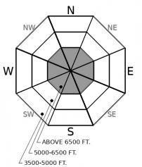
Though avalanche activity is quieting down, human triggered avalanches are still possible today. Watch for lingering instabilities in steep terrain harboring drifted snow. Be careful around terrain traps where the consequences of a small slide could make for big trouble. The safest riding today is in wind-protected terrain.

2. Moderate
?
Above 6500 ft.
1. Low
?
5000-6500 ft.
1. Low
?
3500-5000 ft.
- 1. Low
- 2. Moderate
- 3. Considerable
- 4. High
- 5. Extreme
-
Type ?
-
Aspect/Elevation ?

-
Likelihood ?CertainVery LikelyLikelyPossible
 Unlikely
 -
Size ?HistoricVery LargeLargeSmall

Recent snow and winds have formed soft slabs that may still be sensitive to human triggers. Instabilities are most likely to be found in wind drifted features below ridgelines, rock bands, rollovers, or in cross-loaded gullies. Pay attention to surface textures and how "slabby" the snow feels. Wind slabs will look and feel thicker, and often produce shooting cracks as you cross over them. Seek out soft, fluffy snow in wind-sheltered terrain for the safest riding.
Settled storm totals are 1 to 2 feet in the Swan, 6" to 16" in the Flathead Range, and less than a foot in the Whitefish Range. This weekend's snow accumulated on a mix of crusts and near-surface facets that formed at the beginning of the month. Avalanche activity peaked during the storm on Saturday, with widespread natural and human triggered soft slabs and sluffs reported from the Flathead and Swan Ranges. Slabs were largest in the Swan, and at upper elevations in the Flathead. Some of these were remotely triggered, some surprised people with unexpected propagation. A number of parties were involved in near-misses. Sunday brought continued avalanche activity, with several groups in the Flathead Range triggering small slab avalanches and more skier triggered sluffs.
The storm snow is settling and stabilizing, and there are fewer slopes where you can get into trouble today. In areas that saw smaller storm totals (the Flathead and Whitefish Ranges) lingering instabilities are most likely to be found in terrain where winds have drifted the snow into denser or thicker slabs. Slabs are thicker and more widespread across the terrain in the Swan Range, but have also become increasingly more difficult to trigger. Storm instabilities tend to linger longer on very steep or more convex-shaped slopes. Be especially careful anywhere that wind loading overlaps with unsupported rollovers. 1" to 5" of snow fell overnight, and you can still trigger small sluffs in steep terrain.
Three deep slabs failed in the Flathead Range during a storm on February 1st. On Saturday, a party reported hearing a very large avalanche from the same suspect terrain. Visibility has been limited since then. Today's calm weather will make deep slabs unlikely, however, random cornice falls can still act as triggers. Make it a habit this winter to put your up tracks into the Park or Flathead Range in terrain that is protected from overhead hazards; that way you significantly reduce your exposure time to these unnerving monsters. The same goes for sledders in the Skyland Area. Park and play in terrain that isn't below big, alpine, corniced faces.
Yesterday's blustery winds, which gusted into the 20's and 30's, eased overnight. Winds are currently calm across the forecast area. Mountain temperatures are in the teens to low 20's this morning. 1" to 5" fell overnight, favoring the Continental Divide. A high pressure ridge off of the West Coast is steering northwest flow over Montana. Expect cool temperatures. a mix of clouds and sun, and occasional snow flurries today.
This forecast applies only to backcountry areas outside established ski area boundaries. The forecast describes general avalanche conditions and local variations always occur. This forecast expires at midnight on the posted day unless otherwise noted. The information in this forecast is provided by the USDA Forest Service who is solely responsible for its content.


