| Wednesday | Wednesday Night | Thursday | |
|---|---|---|---|
| Cloud Cover: | Mostly Cloudy | Mostly Cloudy | Mostly Cloudy |
| Temperatures: | 25 to 31 deg. F. | 20 to 23 deg. F. | 30 to 35 deg. F. |
| Wind Direction: | Southwest | Southwest | Southwest |
| Wind Speed: | 24G37 | 18G33 | 16G32 |
| Snowfall: | 2" to 4" in. | 3" to 6" in. | 2" to 4" in. |
| Snow Line: | 2500' | 2500' | 3000' |
Whitefish Range
Swan Range
Flathead Range and Glacier National Park
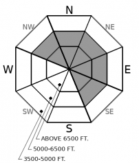
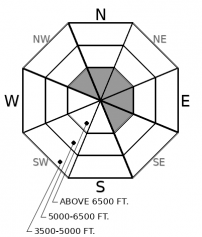
How to read the forecast
Avoid steep, leeward slopes where snow cover may be thin, so you can avoid triggering a very large avalanche that breaks on old weak layers. In areas where more than a few inches of snow accumulates, look for soft slabs of drifted snow on steep slopes. These can be dangerous if they're more than about 8 inches thick and above terrain traps like gullies or dense trees.

2. Moderate
?
Above 6500 ft.
2. Moderate
?
5000-6500 ft.
1. Low
?
3500-5000 ft.
- 1. Low
- 2. Moderate
- 3. Considerable
- 4. High
- 5. Extreme
-
Type ?
-
Aspect/Elevation ?

-
Likelihood ?CertainVery LikelyLikelyPossible
 Unlikely
 -
Size ?HistoricVery LargeLargeSmall

It's probably tempting the Fates (there were 3 in classic myths) to ride steep, leeward slopes with variable snow depths, shallow spots, convexities, or rock bands that leave snowfields unsupported. That's the terrain where a person's weight can still trigger a very large, destructive avalanche that breaks on weak layers near the ground or that formed over the holidays. More relaxing to stick to planar, sheltered slopes where these layers are consistently buried deeply. Most of the recent natural avalanches that broke on these layers have run in the Flathead Range, though the snowpack structure exists in the other ranges as well.
-
Type ?
-
Aspect/Elevation ?

-
Likelihood ?CertainVery LikelyLikelyPossible
 Unlikely
 -
Size ?HistoricVery LargeLargeSmall

In areas where more than a few inches of snow falls today and winds are moderate, expect small slabs of drifted snow that can be dangerous where they're more than about 8 inches thick or above terrain traps. These spots should be easy to identify and avoid. Steer clear of any drifts more than boot-top deep that are sitting on steep slopes. Where they're sitting on a thin but distinct ice layer, they may break wider than expected.
Wet snow avalanches problems didn't develop Tuesday due to more extensive cloud cover than expected. Temperatures have dropped below freezing at valley and mountain stations, though the few stations in and around the Swan Range suggest it's warmest there. A trace to a few inches of new snow has accumulated since Tuesday morning.
The BNSF forecasters reported a large natural avalanche in the Flathead Range that they estimated occurred in the past few days. It appears to have been a triggered by cornice fall - in turn due to the warm temperatures - and didn't look to be one of the destructive natural avalanches that broke on early-season weak layers near the ground. We've had several other reports of large natural avalanches that did break on these layers but likely ran a week or more ago.
Today's undramatic weather won't create new avalanche hazards large enough to be dangerous, unless snowfall is heavier than forecast (see below). However, the danger of triggered and natural avalanches that break near the ground lingers. Weak layers that formed early season (late October and mid November) were most widespread and best developed on upper elevation, leeward slopes. That's also where most of the tree-snapping natural avalanches from last week started. A few started at mid elevations. The weak layers that formed early season and over the holidays (12/24 and 12/31 crust/ facets) are now buried under at least 3 to 6 feet of snow, so a person's weight is unlikely to trigger these monsters except where snow depths are shallow and the layers are closer to the surface. The most straightforward way to avoid finding one of these spots is to stay off of and out from under leeward, upper-elevation start zones and conves or unsupported slopes with variable snow depths.
Weather models this morning are spitting out contradictory snowfall numbers. It's possible the Swan Range and the northern Whitefish Range could pick up 4 to 5 inches of snow by sunset, with more overnight. Add moderate southwesterly winds at ridges, and we've got the recipe for a Wind Slab avalanche problem. If snowfall and winds arrive as forecast, expect some blowing snow at upper elevations and soft drifts and slabs that can be dangerous on steep slopes.
The stout ice layer formed by freezing rain Sunday morning appears widespread in the western half of the region. So far it's mostly a hazard to spirits and limbs. A look at how it might develop into a failure plane as it's loaded is below:
With a dirty ridge moving overhead, we can expect overcast skies, snow showers, and gusty ridgetop winds. Weather models suggest the snowfall will favor the Swan and northern Whitefish Ranges with 4--5 inches today and a trace to three inches across the rest of the region. Favored areas may wring out another to 5 inches tonight. Expect moderate southwest winds at ridges that may mix down to lower elevations at times.
This forecast applies only to backcountry areas outside established ski area boundaries. The forecast describes general avalanche conditions and local variations always occur. This forecast expires at midnight on the posted day unless otherwise noted. The information in this forecast is provided by the USDA Forest Service who is solely responsible for its content.


