| Monday | Monday Night | Tuesday | |
|---|---|---|---|
| Cloud Cover: | Mostly Cloudy | Mostly Cloudy | Mostly Cloudy |
| Temperatures: | 31 to 40 deg. F. | 20 to 25 deg. F. | 29 to 36 deg. F. |
| Wind Direction: | Southwest | Southwest | Southwest |
| Wind Speed: | 10 to 15 | 10 to 15 gusting to 20 | 10 to 15 gusting to 25 |
| Snowfall: | 0" in. | 0" in. | 0 to 1" in. |
| Snow Line: | 5000' | 4000' | 3500' |
Flathead Range and Glacier National Park
How to read the forecast
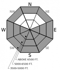
The avalanche danger will rise with warming temperatures and solar radiation. Avoid being on or underneath steep, south-facing slopes if you start to feel the warmth from the sun, or if the snow begins to glop up on your skis, boards, machine, or snowshoes. Be cautious if you venture into mid and upper elevations due to the potential for warming temperatures or smaller avalanches to trigger much larger slab avalanches.

3. Considerable
?
Above 6500 ft.
3. Considerable
?
5000-6500 ft.
2. Moderate
?
3500-5000 ft.
- 1. Low
- 2. Moderate
- 3. Considerable
- 4. High
- 5. Extreme
-
Type ?
-
Aspect/Elevation ?

-
Likelihood ?CertainVery LikelyLikelyPossible
 Unlikely
 -
Size ?HistoricVery LargeLargeSmall

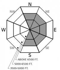
South-facing aspects that receive direct sunlight will produce avalanches large enough to bury or injure you. Warm temperatures alone may produce avalanches on northerly aspects at low elevations. Rollerballs or pinwheels are signs that conditions are ripe for wet loose avalanches. If you see these signs, avoid being on or underneath avalanche terrain with similar characteristics to the one that was rollerballing. To reduce your risk to this problem, seek out shaded, northerly facing slopes at mid and upper elevations.
-
Type ?
-
Aspect/Elevation ?

-
Likelihood ?CertainVery LikelyLikelyPossible
 Unlikely
 -
Size ?HistoricVery LargeLargeSmall

Large, destructive avalanches have happened at mid and upper elevation bands on most aspects in the past 10 days, with January 14 our estimated date for the most recent. Although it has been a week since that slide, warming temperatures, a smaller avalanche, a cornice failure, or a rider have the potential to trigger more. Reduce your exposure by choosing concave or planar slopes with clean runouts. Steer away from steep, rocky slopes on leeward aspects where these avalanches have occurred.
-
Type ?
-
Aspect/Elevation ?

-
Likelihood ?CertainVery LikelyLikelyPossible
 Unlikely
 -
Size ?HistoricVery LargeLargeSmall

Observers continue to find pockets of wind-drifted snow below ridgelines on slopes leeward to westerly winds. Small avalanches breaking one to two feet deep below ridgelines remain a lingering concern. Be cautious traveling near and below leeward ridgelines today, where falling cornices may trigger larger avalanches on slopes below.
Yesterday: What happened? Another freezing rain crust!? YES. It did not take long for people to share photographs and videos of plates of ice. Accompanying the images were comments like "shin breaking," "sounded like a monster growling at me," or "like getting hit by paintballs while sledding though it." So far, the freezing rain crust is found throughout the region on all aspects and most elevations except for areas east of Essex. Other observations from yesterday highlighted isolated areas of roller balling and wet loose avalanches that occurred mid to late afternoon with the influence of the sun. Here are observations from the Whitefish Range, Flathead Range, Swan Range, and Glacier National Park if you are heading out today. More in the observations tab.
Today: If you feel the sun today, heads up. We are expecting the warmest temperatures since the holidays. One variable that will influence today's avalanche danger will be solar radiation. The weather forecast shows the Flathead Range and Glacier National Park will have the least cloud cover, and the Swan and Whitefish Range having mostly cloudy skies. The absence or presence of clouds will dictate how fast the surface crusts break down and the snow below wets. Once the top few inches of snow becomes wet, expect to see widespread avalanching. Wet loose avalanches have the potential to be destructive and run long distances.
The greatest uncertainty today is how the warming will affect persistent weak layers buried in the middle and bottom of the snowpack. Research has shown that layers like these often re-activate during warming trends and increased solar input. That's today. Avoid or travel one at a time underneath large avalanche paths, especially at mid and upper elevations on leeward slopes where weak layers have been stressed the most.
Southwesterly flow will bring warm temperatures to the region, with freezing levels climbing into mid and possibly upper elevation terrain today. Winds will be light to moderate from the south and southwest. Forecasts call for partly to mostly cloudy skies.
This forecast applies only to backcountry areas outside established ski area boundaries. The forecast describes general avalanche conditions and local variations always occur. This forecast expires at midnight on the posted day unless otherwise noted. The information in this forecast is provided by the USDA Forest Service who is solely responsible for its content.


