| Thursday | Thursday Night | Friday | |
|---|---|---|---|
| Cloud Cover: | Overcast | Overcast | Mostly Cloudy |
| Temperatures: | 24 to 29 deg. F. | 13 to 16 deg. F. | 22 to 27 deg. F. |
| Wind Direction: | South | Southwest | West |
| Wind Speed: | 10 to 20, G30 | 10 to 20, G30 | 15 to 25, G40 |
| Snowfall: | 0 to 1" in. | 5" to 8" in. | 0 to 1" in. |
| Snow Line: | 2000' | 1500' | 500' |
Swan Range
How to read the forecast
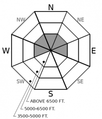
Older drifts may linger on leeward alpine slopes. Small new wind slabs may form in favored terrain. Watch for blowing snow across ridges and rounded drifts below. Shooting cracks are red flags to avoid steep, wind-loaded slopes. Smaller avalanches stepping down to deeper weak layers remains a concern.

2. Moderate
?
Above 6500 ft.
2. Moderate
?
5000-6500 ft.
1. Low
?
3500-5000 ft.
- 1. Low
- 2. Moderate
- 3. Considerable
- 4. High
- 5. Extreme
-
Type ?
-
Aspect/Elevation ?

-
Likelihood ?CertainVery LikelyLikelyPossible
 Unlikely
 -
Size ?HistoricVery LargeLargeSmall

Winds from the south may move the light recent snow onto leeward slopes. Older wind slabs may linger in the most favored terrain below ridgelines an on cross-loaded features. Identify rounded, dune-shaped drifts on steep alpine slopes. Shooting cracks mean unstable wind slabs. Seek sheltered, lower angled slope for better and safer riding.
-
Type ?
-
Aspect/Elevation ?

-
Likelihood ?CertainVery LikelyLikelyPossible
 Unlikely
 -
Size ?HistoricVery LargeLargeSmall

Crusts and weak layers are buried 3 to 6 feet deep, and at the bottom of the snowpack. They are deeper, and it’s less likely you can trigger them in the Swan Range. The main concern in those areas is that a smaller avalanche could suddenly overload them and create a much larger slide.
After almost a week of continuous snow, the sun came out yesterday and we could finally take in stunning views of white, wintry mountains. And what a view! Copious amounts of fluffy snow across the region made people excited to ski and sled. Since January 10th, weather stations across the region account for 1.5-2 feet of new snow. But that doesn’t include settlement. Riders reported closer to 3+ feet of soft but settling storm snow in the Flathead Range yesterday.
All the new powder came with a continuous cycle of avalanches. Observers reported natural and triggered sluffs and soft slabs almost daily during the storm. Views of the peaks yesterday revealed a scarier story. The low-density snow paired with wind transportation overloaded weak layers buried in the middle and lower snowpack. Very large and historic avalanches failed in the alpine terrain of the Flathead Range as recently as Tuesday night! They ran to lower elevations and destroyed swathes of mature timber. See this observation.
The snowpack had a chance to catch its breath with yesterday's quiet weather, but the danger will start to rise again today and this evening. Snowfall resumes favoring the northern and central Whitefish Range. Triggering storm slabs may become likely if we see the higher end of forecasted storm totals and the danger could rise to Considerable. Southerly winds will make new slabs larger in exposed areas. Even where little new snow is expected – in the Swan Range and further east – there is plenty of soft snow available for winds to redistribute onto steep leeward slopes.
Another, stronger pulse of precipitation comes later tonight, spreading storm instabilities through the rest of the forecast area. The danger may remain elevated heading into the weekend.
This forecast applies only to backcountry areas outside established ski area boundaries. The forecast describes general avalanche conditions and local variations always occur. This forecast expires at midnight on the posted day unless otherwise noted. The information in this forecast is provided by the USDA Forest Service who is solely responsible for its content.


