| Thursday | Thursday Night | Friday | |
|---|---|---|---|
| Cloud Cover: | Overcast | Mostly Cloudy | Mostly Cloudy |
| Temperatures: | 20 to 26 deg. F. | 11 to 15 deg. F. | 16 to 22 deg. F. |
| Wind Direction: | Southeast | Southwest | Southwest |
| Wind Speed: | 10 to 20, G30 | 10 to 20, G30 | 15 to 25, G40 |
| Snowfall: | 3" to 5" in. | 3" to 5" in. | 0" in. |
| Snow Line: | 2000' | 1500' | 500' |
Whitefish Range
How to read the forecast
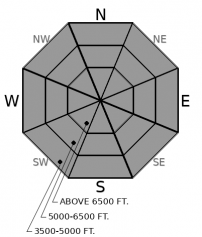
Track storm totals and watch for drifting snow. The danger will rise as new snow accumulates. Triggering storm slabs could become likely if we get more than 5 inches and winds thicken slabs on leeward slopes. Dense new snow that cracks below you is a warning that you should choose lower angled, simple terrain. Smaller avalanches stepping down to deeper weak layers remains a concern.

3. Considerable
?
Above 6500 ft.
2. Moderate
?
5000-6500 ft.
2. Moderate
?
3500-5000 ft.
- 1. Low
- 2. Moderate
- 3. Considerable
- 4. High
- 5. Extreme
-
Type ?
-
Aspect/Elevation ?

-
Likelihood ?CertainVery LikelyLikelyPossible
 Unlikely
 -
Size ?HistoricVery LargeLargeSmall

There is some uncertainty over how much snow will accumulate in the central and northern Whitefish Range by this afternoon. Slabs of new and drifted snow may become easy to trigger if we get the upper end of forecasted snow totals. Track new snow depths. Hand pits are a good way to identify thicker on top of softer snow. Cracking in the new snow means you could trigger it on steeper slopes.
-
Type ?
-
Aspect/Elevation ?

-
Likelihood ?CertainVery LikelyLikelyPossible
 Unlikely
 -
Size ?HistoricVery LargeLargeSmall

Crusts and weak layers are buried 3 to 6 feet deep, and at the bottom of the snowpack. They appear to be less reactive in the Swan and Whitefish Ranges. The main concern in those areas is that a smaller avalanche could suddenly overload them and create a much larger slide.
After almost a week of continuous snow, the sun came out yesterday and we could finally take in stunning views of white, wintry mountains. And what a view! Copious amounts of fluffy snow across the region made people excited to ski and sled. Since January 10th, weather stations across the region account for 1.5-2 feet of new snow. But that doesn’t include settlement. Riders reported closer to 3+ feet of soft but settling storm snow in the Flathead Range yesterday.
All the new powder came with a continuous cycle of avalanches. Observers reported natural and triggered sluffs and soft slabs almost daily during the storm. Views of the peaks yesterday revealed a scarier story. The low-density snow paired with wind transportation overloaded weak layers buried in the middle and lower snowpack. Very large and historic avalanches failed in the alpine terrain of the Flathead Range as recently as Tuesday night! They ran to lower elevations and destroyed swathes of mature timber. See this observation.
The snowpack had a chance to catch its breath with yesterday's quiet weather, but the danger will start to rise again today and this evening. Snowfall resumes favoring the northern and central Whitefish Range. Triggering storm slabs may become likely if we see the higher end of forecasted storm totals and the danger could rise to Considerable. Southerly winds will make new slabs larger in exposed areas. Even where little new snow is expected – in the Swan Range and further east – there is plenty of soft snow available for winds to redistribute onto steep leeward slopes.
Another, stronger pulse of precipitation comes later tonight, spreading storm instabilities through the rest of the forecast area. The danger may remain elevated heading into the weekend.
This forecast applies only to backcountry areas outside established ski area boundaries. The forecast describes general avalanche conditions and local variations always occur. This forecast expires at midnight on the posted day unless otherwise noted. The information in this forecast is provided by the USDA Forest Service who is solely responsible for its content.


