| Sunday | Sunday Night | Monday | |
|---|---|---|---|
| Cloud Cover: | Mostly Cloudy | Overcast | Overcast |
| Temperatures: | 16 to 22 deg. F. | -10 to -3 deg. F. | 0 to 7 deg. F. |
| Wind Direction: | Southeast | Northeast | Northeast |
| Wind Speed: | 12G25 | 24G38 | 19G39 |
| Snowfall: | 4" to 8" in. | 10" to 14" in. | 3" to 4" in. |
| Snow Line: | 500' | 0' | 0' |
Swan Range
Flathead Range and Glacier National Park
How to read the forecast
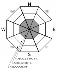
Up to a foot of snow has stacked up, creating slab avalanches large enough to bury or injure you. Proceed with caution at mid and upper elevations as snow and wind continue to stress weak layers buried 2 to 3 feet deep. Collapses, shooting cracks, or blowing snow are signs to seek terrain with slope angles 30 degrees or less. Expect the danger to rise as another pulse of snow and wind approach our area this evening.

3. Considerable
?
Above 6500 ft.
2. Moderate
?
5000-6500 ft.
2. Moderate
?
3500-5000 ft.
- 1. Low
- 2. Moderate
- 3. Considerable
- 4. High
- 5. Extreme
-
Type ?
-
Aspect/Elevation ?

-
Likelihood ?CertainVery LikelyLikelyPossible
 Unlikely
 -
Size ?HistoricVery LargeLargeSmall

Saturday, skiers and riders reported triggering soft slab and loose dry avalanches. As this new snow settles, it will continue to form a cohesive slab of snow that if triggered, can be large enough to bury or injure you. Watch for areas where winds may have drifted snow into thicker, denser slabs in upper elevations. If you see shooting cracks within the new snow, seek out slopes 30 degrees or less in steepness. Though storm slab avalanches can be manageable to the seasoned rider, don’t rule out the possibility that the weight of one of these avalanches may trigger a much larger, deadly avalanche.
-
Type ?
-
Aspect/Elevation ?

-
Likelihood ?CertainVery LikelyLikelyPossible
 Unlikely
 -
Size ?HistoricVery LargeLargeSmall

As more weight continues to add stress to the snowpack, concern remains for the potential to trigger a dangerous avalanche 2 to 3 feet deep. Be extra cautious of slopes that have received additional loading from wind transported snow. Several weak layers of faceted crusts and surface hoar that developed through the holidays have not been put to bed yet, as shown here. As you gain middle and upper elevations, seek out slopes less than 30 degrees if you feel collapses and shooting cracks under your feet.
-
Type ?
-
Aspect/Elevation ?

-
Likelihood ?CertainVery LikelyLikelyPossible
 Unlikely
 -
Size ?HistoricVery LargeLargeSmall

Winds out of the South and Southwest overnight have likely drifted snow onto North through East aspects that can be reactive to the weight of a human or machine. Blowing snow and pillowy surfaces are your cue to steer away from leeward facing slopes. Pay attention to wind direction today as we may see easterly winds during the afternoon/evening hours, which will create wind slabs onto westerly facing slopes. Don’t rule out the possibility that the weight of one of these avalanches may trigger a much larger, deadly avalanche.
In the past 48 hours, we have received a range of 4 to 12 inches of new snow and .8 to 1.5 inches of water, with favored locations being Glacier National Park and the Swan Range. Forecasters and other avalanche professionals yesterday reported numerous loose dry and soft slab avalanches large enough to bury or injure you at mid and upper elevations. Check out the observations from Whitefish, Glacier National Park, and the Flathead Range if you are heading into any of those regions today.
With new snow on the ground, winds will be hovering around a speed that can create slabs of wind drifted snow onto leeward aspects. Wind speeds overnight have been predominately out of the S and SSW, so expect this problem to be located on north and east facing ridgelines. The kicker will be the easterly winds we expect to see. Currently, these are forecast to arrive around the time of the setting sun; however, pay attention as we may see an early arrival, which will create more widespread wind slabs.
Recently referred to as the rottweiler in the snowpack, persistent weak layers have begun to bark at us. Though they have not shown their face in the form of an avalanche, they are certainly there, as Zach experienced and described in the video below. Proceed with caution the next few days if you venture into mid and upper elevation bands. Give the snowpack time to adjust to the weight of new snow and winds. We are looking at another round of snow and wind tonight as a front approaches from the north.
Today, expect a range from 4 to 10 inches of new snow depending on your location with light to moderate winds out of the South. Temperatures will hover in the mid-20s before plummeting into the single digits and negatives tonight.
This forecast applies only to backcountry areas outside established ski area boundaries. The forecast describes general avalanche conditions and local variations always occur. This forecast expires at midnight on the posted day unless otherwise noted. The information in this forecast is provided by the USDA Forest Service who is solely responsible for its content.


