| Thursday | Thursday Night | Friday | |
|---|---|---|---|
| Cloud Cover: | Mostly Cloudy | Mostly Cloudy | Mostly Cloudy |
| Temperatures: | 13 to 18 deg. F. | 1 to 5 deg. F. | 16 to 20 deg. F. |
| Wind Direction: | Northwest | Northwest | South |
| Wind Speed: | 5 to 15, G25 | 0 to 10 | 5 to 15 |
| Snowfall: | 1-3" in. | 0" in. | 2" to 4" in. |
| Snow Line: | 0' | 0' | 0' |
Whitefish Range
Swan Range
How to read the forecast
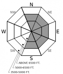
The natural cycle is over and the avalanche danger is trending down, but we aren't out of the woods yet. Skiers and riders can still trigger large and dangerous avalanches that break several feet deep on weak layers that were buried at the start of the year. Carefully assess the snowpack before moving into avalanche terrain, and choose shorter, lower consequence pitches over big terrain or terrain traps.

2. Moderate
?
Above 6500 ft.
2. Moderate
?
5000-6500 ft.
1. Low
?
3500-5000 ft.
- 1. Low
- 2. Moderate
- 3. Considerable
- 4. High
- 5. Extreme
-
Type ?
-
Aspect/Elevation ?

-
Likelihood ?CertainVery LikelyLikelyPossible
 Unlikely
 -
Size ?HistoricVery LargeLargeSmall

Over the past few days, several feet of snow, complemented with strong southwesterly winds have stressed a smorgasbord of weak layers and crusts. Numerous natural and human-triggered avalanches failed on these layers during the storm: some ran long distances burying popular road routes, some were remotely triggered. The snowpack is now in recovery mode, which means slabs are harder to trigger and weak layers are starting to adjust. However, some slopes are waiting to ruin your day. The only way to manage this problem is to carefully assess the snowpack or keep your terrain choices simple. Shooting cracks or whumphing sounds are clear signs that the snowpack is unstable.
-
Type ?
-
Aspect/Elevation ?

-
Likelihood ?CertainVery LikelyLikelyPossible
 Unlikely
 -
Size ?HistoricVery LargeLargeSmall

Watch for small, shallow wind slabs to form today in areas favored by new snow and northwest winds. These should be small and isolated to a few terrain features near ridgelines or in gullies. Yesterday's strong southwest winds left a larger, stiffer breed of wind slabs littered across north and east facing terrain features. These are harder to trigger, but could break above you. The easiest way to avoid both of these problems is traveling in wind protected terrain, where the snow is softer, or on windward features, where the recent snow has been eroded.
Since Monday, Northwest Montana has been pounded by snow, and if I dare use a cowboy metaphor, the horses have bolted from the stable. 2" to almost 4" of Snow Water Equivalent, and storm totals that require a yardstick to measure, brought a flurry of natural and human triggered avalanches on Tuesday. Southwest winds increased on Wednesday spurring another round of natural avalanches in Glacier Park, and likely in other alpine locations. Winds are easing, temperatures are decreasing, and the snowpack is settling down. Now its time for the horses to head back to the barn.
The foals, fresh pockets of new and drifted snow that accumulate today, aren't much to worry about unless you get corned in a terrain trap. The yearlings, slabs of drifted snow that formed yesterday, are ornery enough that you need to use caution, but they are also fairly predictable. Several feet of snow was available for transport before yesterday's winds, and this snow has been redistributed into leeward locations at mid and upper elevations. Keep an eye on where drifts are thicker and stiffer and you can wrangle them back to the barn safely. The wild mustangs, however, are the unpredictable ones. These are the persistent slabs overlying surface hoar, near surface facets, and crusts. Their behavior is erratic and unpredictable: they might not give you signs of stirring until they unleash in a big way. Check out these crowns from John F Stevens Canyon observed yesterday...these are the types of avalanches you don't want to mess with. It appears as if one of the Clydesdales got out of the barn as well, a very thick hard slab that likely broke on November weak layers. To wrestle the Clydedales and Mustangs back to the barn, you need to exercise patience. Give them time and they will behave. Start with smaller, less consequential avalanche terrain if you are stepping out. Weak layers appear to be most reactive and more widespread in Flathead and Glacier Park; thus, we are slower to lower the danger there.
Avalanche Education: We still have spots open for a number of Intro, Partner Rescue, and Level 1 classes. Sign up and calendar are here.
The weather is quieting down: winds are light with moderate gusts this morning and mountain temperatures have cooled into the teens. A weak disturbance today will bring a few inches, favoring the Swan Range.
This forecast applies only to backcountry areas outside established ski area boundaries. The forecast describes general avalanche conditions and local variations always occur. This forecast expires at midnight on the posted day unless otherwise noted. The information in this forecast is provided by the USDA Forest Service who is solely responsible for its content.


