| Monday | Monday Night | Tuesday | |
|---|---|---|---|
| Cloud Cover: | Partly Cloudy | Mostly Cloudy | Mostly Cloudy |
| Temperatures: | 20 to 25 deg. F. | 17 to 20 deg. F. | 25 to 29 deg. F. |
| Wind Direction: | South | Southwest | Southwest |
| Wind Speed: | 5 to 10 gusting to G20 | 15 to 20 gusting to 35 | 20 to 25 gusting to 40 |
| Snowfall: | 0" in. | 2" to 6" in. | 7" to 12" in. |
| Snow Line: | 1500' | 2000' | 1500' |
Swan Range
How to read the forecast
Use safe travel techniques as you enjoy a last day of calm weather and low avalanche danger before a storm arrives tonight. Carry rescue gear, travel with a good partner, and limit your exposure in steep terrain by riding one at a time. Watch for terrain traps that can turn a small sluff into a bigger problem. Expect the danger to change as a storm system approaches tomorrow.

1. Low
?
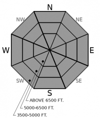
Above 6500 ft.
1. Low
?
5000-6500 ft.
1. Low
?
3500-5000 ft.
- 1. Low
- 2. Moderate
- 3. Considerable
- 4. High
- 5. Extreme
-
Type ?
-
Aspect/Elevation ?

Conditions are generally safe in the Swan Range today. Travel with rescue gear and a good partner. You are most likely to get in trouble on very steep slopes where the consequences of a small sluff can be amplified by terrain traps below. Approach extreme terrain from the top down and expose one person at a time. Let your buddy dig the sled out while you spot them from a safe distance. Tomorrow, expect the avalanche danger to rise as a storm system moves into our area.
Here we are, a week after Christmas and you’re cleaning up the decorations to transition into 2020. The excitement has been winding down since the Solstice. You’ve relaxed a little with not too much think about. But as you pack away the ornaments and look forward to the new year, you notice a lump in the bottom of your stocking. It’s a stale, almost-forgotten box of wafer cookies…
The last major avalanche activity in our area came and went with the storm on the 20th. Reports of large avalanches breaking on layers of crusts and weak facets came from near the Continental Divide and the northern Whitefish Range. More recently, the only feedback we’ve had from these persistent weak layers has been spotty. Snowpack tests continue to show that facets and crusts from November still have the potential to fail and propagate – except when they don’t. The inconsistency is because the facets are rounding and gaining strength as the slab above them thickens and hardens. New, hard crusts near the surface make it harder for you to affect the bottom of the snowpack. But not all the wafers are stale. On Friday, our neighbors in Fernie reported that a snowmobile remotely-triggered a large persistent slab avalanche in steep and rocky terrain.
So while the likelihood of triggering a big avalanche is down, the consequences remain high. You could find a stale cookie, or you could bite into a sweet spot where the sugary layers between the crusts are still weak and loose. Stay out of trouble by using the terrain to your advantage. Rather than betting it all by riding on just any old slope, choose wisely. The potential trouble lies on alpine slopes above about 6,000 feet in big, steep terrain where the snow cover varies in thickness. Convex break-overs and rocky outcrops are potential trigger points. You can find more slopes that meet that description in the Flathead Range and Glacier National Park.
People reported triggering small sluffs across the region over the weekend because 3-10 inches of light new snow that fell last week was bonding poorly to the underlying crusts. That problem is diminishing as the recent snow settles. But approach extreme terrain with an eye for consequences. Are there terrain traps where a small sluff could knock you off your feet and sweep you over a cliff or into trees?
Pacific moisture looks on tap for much of the coming week. If the weather forecast verifies this may be the last quiet day for a while. Expect the avalanche danger to rise as the ball drops on the new year.
Expect conditions to remain calm today, but change is on the way. Pacific moisture leads into Idaho and Montana tomorrow with moderate to heavy snow possible through Wednesday afternoon. Winds pick up from the southwest as a cold front pushes through our area by Wednesday morning.
This forecast applies only to backcountry areas outside established ski area boundaries. The forecast describes general avalanche conditions and local variations always occur. This forecast expires at midnight on the posted day unless otherwise noted. The information in this forecast is provided by the USDA Forest Service who is solely responsible for its content.


