| Wednesday | Wednesday Night | Thursday | |
|---|---|---|---|
| Cloud Cover: | Mostly Cloudy | Partly Cloudy | Partly Cloudy |
| Temperatures: | 20 to 25 deg. F. | 9 to 14 deg. F. | 18 to 23 deg. F. |
| Wind Direction: | West | Northwest | Southwest |
| Wind Speed: | 5 to 10 | 5 to 10 | 5 to 15 G20 |
| Snowfall: | 0" in. | 0" in. | 0" in. |
| Snow Line: | 1000' | 500' | 0' |
Whitefish Range
Swan Range
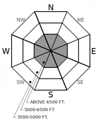
How to read the forecast
The Whitefish and Swan Ranges are giving us the gift of a quiet snowpack. The snowpack continues to recover from last weekend's storm: the odds of triggering an avalanche today are low, but not impossible. The lingering concern - slabs several feet thick over early-season weak layers - are most likely to be triggered from steep, high elevation terrain with variable snow coverage or unsupported rollovers. Keep your travel protocols tight because a resulting slide will be large.

1. Low
?
Above 6500 ft.
1. Low
?
5000-6500 ft.
1. Low
?
3500-5000 ft.
- 1. Low
- 2. Moderate
- 3. Considerable
- 4. High
- 5. Extreme
-
Type ?
-
Aspect/Elevation ?

-
Likelihood ?CertainVery LikelyLikelyPossible
 Unlikely
 -
Size ?HistoricVery LargeLargeSmall

In the Whitefish and Swan Ranges, it has been over two weeks since we have observed an avalanche breaking on faceted early-season crusts. Obvious signs of instability, such as shooting cracks or collapses, have also waned in the past week. Under our current weather pattern, persistent slabs 2 to 4 feet thick are becoming increasingly isolated and difficult to trigger. Yet the snowpack structure and some test results continue to give us pause near and into the upper elevation band: there may be a few chunks of coal out there that could ruin your Christmas. You are most likely to trigger one of these thick, hard slabs from a thin spot on the slope. Shallow trigger points are more common in complex, alpine terrain with rocks and cliff bands.
Twas the night before Christmas, when all through the peaks
Not a snowflake was falling, the winds had ended their streak;
The beacons, shovels, and probes were packed with care,
In hopes that more powder soon would be there;
The faceted crusts lay quietly lurking below 3 feet of snow
Still demanding caution for those wanting to go;
The danger was most acute in The Flathead and Glacier Park
Where a handful of D3’s last weekend have left their mark;
From Friday's warm, wet, and wind arose such a clatter,
Observers sprang from their ventures to relay what was the matter;
The sun on the breast of the windblown snow,
Gave the lustre of crowns and avalanche debris below;
Off Furlong, off Nyack, off Cameahwait and Snowshed,
These are the slides that keep me restless in bed;
For fear that a skier or rider might trigger the same,
While crossing a shallow spot in upper elevation terrain;
Although stability is now improving, keep caution in site,
Happy Christmas to all, and to all a good night!
Merry Christmas from the Flathead Avalanche Center. For a more technical, albeit less festive discussion on our current snowpack, take a look at yesterday's forecast discussion, which still applies.
Up to 3" of new snow fell yesterday at all elevations, treating us to a White-ish Christmas. Today should be dry with cloud coverage dissipating into tomorrow. Winds remain light until a weak system approaches on Thursday afternoon which should bring light snowfall on Friday. Temperatures are in the teens and 20's this morning; they will remain cool throughout the rest of the week.
This forecast applies only to backcountry areas outside established ski area boundaries. The forecast describes general avalanche conditions and local variations always occur. This forecast expires at midnight on the posted day unless otherwise noted. The information in this forecast is provided by the USDA Forest Service who is solely responsible for its content.


