| Saturday | Saturday Night | Sunday | |
|---|---|---|---|
| Cloud Cover: | Mostly Cloudy | Mostly Cloudy | Overcast |
| Temperatures: | 33 to 38 deg. F. | 28 to 31 deg. F. | 34 to 40 deg. F. |
| Wind Direction: | Southwest | Southwest | Southwest |
| Wind Speed: | 20-25 gusting to 50 | 25-20 gusting to 45 | 10-15 gusting to 25 |
| Snowfall: | 0" in. | 0" in. | 0" in. |
| Snow Line: | 5500' | 4500' | 4000' |
Swan Range
How to read the forecast
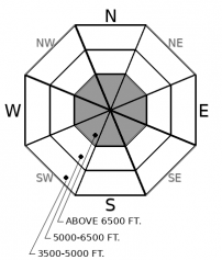
Dangerous conditions exist at upper elevations, thanks to a combination of new and drifted snow and rapidly warming temperatures. At mid-elevations, rain and above freezing temperatures have made wet snow avalanches possible on steep slopes. You can ride safe in these complex conditions by keeping it simple. Avoid being on or under steep slopes with more than about a foot of new and/ or drifted snow. At mid elevations, steer clear of steep slopes with gloppy wet snow.

3. Considerable
?
Above 6500 ft.
2. Moderate
?
5000-6500 ft.
1. Low
?
3500-5000 ft.
- 1. Low
- 2. Moderate
- 3. Considerable
- 4. High
- 5. Extreme
-
Type ?
-
Aspect/Elevation ?

-
Likelihood ?CertainVery LikelyLikelyPossible
 Unlikely
 -
Size ?HistoricVery LargeLargeSmall

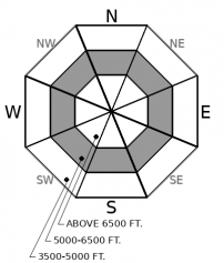
Avoid being on or under slopes steeper than about 30 degrees with more than about a foot of new or drifted snow. In this terrain, you can trigger small to large slabs that break in the fresh snow or at the old snow interface. These slides are most likely where gusty winds have thickened and stiffened the slabs. The hazard is most widespread on steep, leeward slopes (northwest to northeast to southeast) at upper elevations. It is isolated at mid elevations. Shooting cracks and recent natural avalanches are a clear sign of this danger.
-
Type ?
-
Aspect/Elevation ?

-
Likelihood ?CertainVery LikelyLikelyPossible
 Unlikely
 -
Size ?HistoricVery LargeLargeSmall

Steer clear of steep slopes peppered with potential trigger points - rocks, small cliff bands, and variable snow depths. On these slopes, your weight or the weight of your machine can trigger slides that break 3 to 4 feet deep, on weak facets and crusts that developed early this season. Because you can also trigger these avalanches from below or gentle terrain on adjacent slopes, stay out from under steep start zones, particularly those near ridges where winds are actively drifting snow. These layers are most widespread above about 6000 feet.
-
Type ?
-
Aspect/Elevation ?

-
Likelihood ?CertainVery LikelyLikelyPossible
 Unlikely
 -
Size ?HistoricVery LargeLargeSmall

On steep slopes with more than about eight inches of wet snow, you can trigger wet snow avalanches that can be dangerous. These conditions will be most common in the few hundred feet of elevation on either side of the rain/ snow line - roughly 5500 feet. If you see rollerballs or release them with your machine or boards, you've found that wet snow. They may have outsized consequences if they tangle you into the bush where you can't escape the debris.
Wow. What a hot mess. Friday's hit-and-run storm dented the bumper in the Swan Range, sideswiped the Whitefish Range, and totaled the car in central Glacier Park. It brought a high rain/ snow line, gusty winds, and highly variable snowfall amounts. It favored northern Glacier National Park with several inches of SWE or rain, depending on elevation, while the Whitefish Range picked up over an inch of SWE. The southern reaches of the forecast region saw less snow. Winds were southwesterly, with gusts of 30 to 70 mph at upper elevations. Yep, 70 at Mt. Aeneas. Temperatures rose to near or above freezing, even at upper elevations. By the end of Friday, we had reports of small skier and explosive-triggered slides in the southern Whitefish Range and large natural avalanches in John Stevens Canyon, including one ogre that broke near the ground on a heavily wind-loaded slope.
Sifting through the wreckage, one thing is clear. Warming, wind-drifted snow, and storm snow have combined to create dangerous conditions at upper elevations across the forecast region. The combinations are different in different zones, and even across zones. Nonetheless, today you can trigger large slabs of new and drifted snow, or avalanches that break near the ground on weak facets and crusts that formed earlier this season. Natural and remotely-triggered avalanches are also possible, particularly in the eastern part of the forecast region. And to top it off, above-freezing temperatures and rain at mid elevations make triggering small wet loose avalanches possible; these could leave you tangled in the bush under heavy debris. Not a story you want to tell.
Today's complex conditions demand conservative choices for where to ride, and once you're at your destination, careful and cautious routefinding and group management. The nature of the avalanche hazard will vary in short distances, particularly above 6000 feet. The most straightforward way of dealing with complexity like this is to keep it simple. Choose low-angle, planar slopes away from the runouts of avalanche paths with fresh drifts. As the large slide in John Stevens canyon showed, fractures on the facets and crusts near the ground can easily connect across gullies and snowfields that look like they barely have enough snow to ride. Choose approaches and exits that steer clear of steep slopes above terrain traps, where small wet snow and soft slab avalanches can have exaggerated consequences.
Today's weather will keep the danger elevated at upper elevations. The powerful southwesterly winds will continue near ridgelines, temperatures will remain above freezing, and the Whitefish Range may see more snowfall.
Warm air streamining in from the south will keep temperatures unseasonably warm into Sunday. Expect highs near or above freezing even at upper elevations. Winds will remain moderate to strong from the southwest. Snow and rain showers may linger, with a few inches of snow accumulating in the northern reaches of the forecast region.
This forecast applies only to backcountry areas outside established ski area boundaries. The forecast describes general avalanche conditions and local variations always occur. This forecast expires at midnight on the posted day unless otherwise noted. The information in this forecast is provided by the USDA Forest Service who is solely responsible for its content.


