| Thursday | Thursday Night | Friday | |
|---|---|---|---|
| Cloud Cover: | Mostly Cloudy | Mostly Cloudy | Mostly Cloudy |
| Temperatures: | 24 to 27 deg. F. | 20 to 24 deg. F. | 30 to 35 deg. F. |
| Wind Direction: | South | South | Southwest |
| Wind Speed: | 15-20G36 | 15-20G47 | 20-30G70 |
| Snowfall: | 5" to 8" in. | 8" to 12" in. | 10" to 14" in. |
| Snow Line: | 1500' | 3000' | 4500' |
Whitefish Range
Swan Range
Flathead Range and Glacier National Park
How to read the forecast
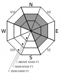
Near upper elevations, the danger of triggering slides several feet deep lingers. Choose planar slopes away from rocky outcroppings to reduce your risk of disturbing a sleeping giant. As a winter storm arrives today, the danger of triggering avalanches involving new snow will rise. Steer clear of steep slopes with more than 8 inches of new and drifted snow.
An AVALANCHE WATCH in effect for the Whitefish Range. The danger is expected to rise to HIGH tomorrow or Saturday.

2. Moderate
?
Above 6500 ft.
2. Moderate
?
5000-6500 ft.
1. Low
?
3500-5000 ft.
- 1. Low
- 2. Moderate
- 3. Considerable
- 4. High
- 5. Extreme
-
Type ?
-
Aspect/Elevation ?

-
Likelihood ?CertainVery LikelyLikelyPossible
 Unlikely
 -
Size ?HistoricVery LargeLargeSmall

The sleeping giants. We have yet to see many of them move; however, we hear them moan and groan when traveling at and above 6500 ft. People are reporting these groans (whumpfing collapses) on a wide variety of aspects. Safer terrain options are found at mid-elevations where the slabs and weak layers are less developed and more anchored by vegetation. If the weather and snowpack tell you to step into high elevations today, choose planar slopes away from rocky outcroppings to reduce your risk.
-
Type ?
-
Aspect/Elevation ?

-
Likelihood ?CertainVery LikelyLikelyPossible
 Unlikely
 -
Size ?HistoricVery LargeLargeSmall

The old: Winds have been transporting snow for the past three days onto leeward aspects near ridgelines and cross-loaded features. The resulting slabs are currently small and stubborn but may become harder to identify as new snow covers them. The new: As snow begins to fall, watch for instabilities and storm slab avalanches on the new/old snow interface. If you see snow stacking up 8 inches or more, seek low angle terrain as these avalanches could be consequential.
Today storm slab avalanches could be a hit or miss during daylight hours. With the storm reaching our area midday, snow intensity will dictate the rise of avalanche danger. The Swan range is favored with 6 to 10 inches of snow possible. The Flathead and Glacier National Park look to be less favored, with 1 to 4 inches of snow. What this tells us, depending on your specific location, storm slabs could become widespread and sensitive, or remain isolated and reactive throughout the day. A simple way to go about this is to be measuring current snowfall. Eight inches of new with winds can produce avalanches big enough to bury or injure you. Be conservative, and if you see this happening, seek powder in low angle terrain.
Another report of a whumpfing collapse yesterday makes it clear that weak layers of faceted crusts and surface hoar are still calling out to us. On top of that, photos of very large avalanches were taken yesterday on Nyack and Penrose mountain. These likely occurred just after the most recent storm. Conflicting messages are making this persistent slab avalanche problem challenging to forecast. Consistent whumpfing collapses with few avalanches has given us uncertainty of predicting when slides will happen. Maybe this next storm will be the ticket to overburdening the week layers and causing avalanches, or it will remain in place and begin to strengthen the snowpack further. Time will tell.
A winter storm will enter the region today. Expect snow accumulations to vary from 1 to 4 inches in Flathead and Glacier to a possibility of 5 to 10 in the Swan. Winds will increase with sustained speeds in the moderate category with gusts as strong as 40 mph. Temperatures will be in the mid to upper 20s.
This forecast applies only to backcountry areas outside established ski area boundaries. The forecast describes general avalanche conditions and local variations always occur. This forecast expires at midnight on the posted day unless otherwise noted. The information in this forecast is provided by the USDA Forest Service who is solely responsible for its content.


