| Tuesday | Tuesday Night | Wednesday | |
|---|---|---|---|
| Cloud Cover: | Mostly Cloudy | Mostly Cloudy | Partly Cloudy |
| Temperatures: | 22 to 28 deg. F. | 12 to 17 deg. F. | 22 to 28 deg. F. |
| Wind Direction: | Southwest | Southwest | South |
| Wind Speed: | 10 to 20, G35 | 10 to 20, G35 | 5 to 10, G 25 |
| Snowfall: | 0" to 1" in. | 0" in. | 0" in. |
| Snow Line: | 1500' | 1000' | 500' |
Whitefish Range
Swan Range
How to read the forecast
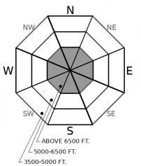
Stable weather is allowing the snowpack to catch its breath after an active December. Convexities and thin, rocky areas at upper elevations are most likely to get you in trouble: Slabs up to several feet thick still have the potential to be triggered on early-season crusts and surface hoar layers.

2. Moderate
?
Above 6500 ft.
1. Low
?
5000-6500 ft.
1. Low
?
3500-5000 ft.
- 1. Low
- 2. Moderate
- 3. Considerable
- 4. High
- 5. Extreme
-
Type ?
-
Aspect/Elevation ?

-
Likelihood ?CertainVery LikelyLikelyPossible
 Unlikely
 -
Size ?HistoricVery LargeLargeSmall

December's snowfall has left slabs several feet thick over a multitude of faceted crusts and surface hoar layers. Near and above 6,500' in elevation, these layers have been barking at us for several weeks with natural avalanches, shooting cracks, and audible whumpfs in the snowpack. The largest, most dangerous slabs are lurking in leeward start zones in high, alpine terrain. The snowpack is showing signs of improvement during our current lull in snowfall. However, if you trigger an avalanche on one of these weak layers, it could surprise you with how wide it propagates and how difficult it will be to escape from. The safest way to avoid this problem is to ride at mid-elevations where the slabs and weak layers aren't as well developed and are more anchored by underbrush. At higher elevations, reduce your risk by avoiding steep rollovers or thin, rocky areas.
-
Type ?
-
Aspect/Elevation ?

-
Likelihood ?CertainVery LikelyLikelyPossible
 Unlikely
 -
Size ?HistoricVery LargeLargeSmall

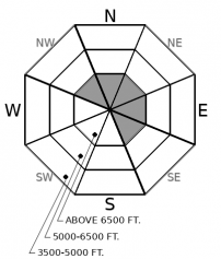
Pay attention for fresh wind slab formation. An increase in southwest wind speeds in the past 24 hours may be enough to drift snow into small pockets of wind drifted slabs. If you are traveling in wind affected terrain, look for surface clues to indicate the wind has been forming slabs, such as recent drifts, cracking below your feet, or blowing snow. A small wind slab can get you into trouble if it drags you into a terrain trap.
Wind speeds increased yesterday and last night. Mt. Aeneas, Snowslip, and Hornet are showing moderate to strong southwest winds, which exceed the winds that came with last Friday's snowfall. In areas where the snow surface was soft and fluffy but is now being transported by winds, you might find fresh wind slab formation.
Although wind slabs are the freshest news, our primary concern remains persistent slabs breaking on crusts or surface hoar layers that formed earlier in November or October. In the past few days, we have noted more natural avalanche activity that appeared to fail on these layers last Friday, from Red Meadow and Rescue Basin. Without the added stress of new snow since Friday, these slabs are becoming less and less reactive. I like the analogy of a puny kid going to the gym for the first time. If you give him a barbell on his first day in the gym, he might buckle under the weight. That was our first avalanche cycle on December 8th. After he's been working the barbell for a week or so, he starts to adjust to the weight of the bar. Then you add another 40 pounds and watch nervously to see what happens. He buckles again, perhaps not as dramatically as the first time. That was our December 13th cycle. Now he's getting stronger. He can crank out a few more bench presses and handle the weight unless you bother him too much. Later this week, we'll start to add more weight to his bench press routine and see how well he can handle it.
A high-pressure ridge is slowly moving our way. Winds are already declining and cloud cover will start to dissipate as the ridge axis moves overhead later today or tonight. A series of warm, wet storms is on the menu for later this week.
This forecast applies only to backcountry areas outside established ski area boundaries. The forecast describes general avalanche conditions and local variations always occur. This forecast expires at midnight on the posted day unless otherwise noted. The information in this forecast is provided by the USDA Forest Service who is solely responsible for its content.


