| Saturday | Saturday Night | Sunday | |
|---|---|---|---|
| Cloud Cover: | Mostly Cloudy | Mostly Cloudy | Mostly Cloudy |
| Temperatures: | 19 to 25 deg. F. | 11 to 16 deg. F. | 16 to 22 deg. F. |
| Wind Direction: | West | West | West |
| Wind Speed: | 8 | 0G21 | 1G23 |
| Snowfall: | 1" in. | 1" in. | 0" in. |
| Snow Line: | 1000' | 500' | 0' |
Whitefish Range
Swan Range
How to read the forecast
Self discipline will help keep you out of trouble today. Make conservative terrain choices and avoid steep, wind drifted slopes. Remember that buried weak layers may still be triggered from a distance, or from below. Avoid steep, alpine slopes and the runouts of large avalanche paths. Whumpfing collapses and shooting cracks are good reminders to keep it simple, keep it mellow.

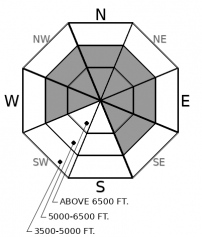
3. Considerable
?
Above 6500 ft.
3. Considerable
?
5000-6500 ft.
1. Low
?
3500-5000 ft.
- 1. Low
- 2. Moderate
- 3. Considerable
- 4. High
- 5. Extreme
-
Type ?
-
Aspect/Elevation ?

-
Likelihood ?CertainVery LikelyLikelyPossible
 Unlikely
 -
Size ?HistoricVery LargeLargeSmall

Between 15 and 20” of new snow fell at Stahl Peak and in Noisy basin recently. We have few reports of avalanches in sheltered areas. However, where westerly winds have created pillowy drifts or thickened slabs, riders could trigger avalanches at middle and upper elevations. Several more inches may accumulate in the Swan Range through tonight, adding a little more load to fresh slabs. Be conservative and cautious near steep leeward and crossloaded terrain features. Shooting cracks and recent natural avalanches are red flag signs of danger.
-
Type ?
-
Aspect/Elevation ?

-
Likelihood ?CertainVery LikelyLikelyPossible
 Unlikely
 -
Size ?HistoricVery LargeLargeSmall

On steep, upper elevation slopes, you may be able to trigger large slabs that break around crusts that formed in late October and mid November, or surface hoar buried on 11/23. You can trigger avalanches that break on these layers from long distances, or from shallower, rocky areas. Step back from steep slopes if you see the unambiguous signs of instability - shooting cracks, whumpfing collapses, and recent slides.
Since Wednesday the 11th, a major storm has practically doubled the snowpack. Precipitation favored the western part of our forecast area. Stahl Peak picked up about 2.5” of snow-water equivalent (SWE), Noisy Basin SNOTEL reported more than 3” of new SWE, and Flattop Mountain gained around 1.5” of new water. The total water load at each of those 3 weather stations increased by over 20% in just 4 days! Westerly winds peaked Thursday night, drifting snow and further increasing the load on leeward and crossloaded terrain.
Natural and human triggered avalanches failing within the top-heavy storm snow were reported yesterday. These avalanches were small to large and ran at middle and upper elevations, on a variety of aspects, though primarily on wind-affected slopes. WMR Ski Patrol triggered storm slabs with explosives that ran surprisingly far. On steep, open slopes where westerly winds have stiffened the surface, slabs 1-2 feet thick are still a hazard.
But the action hasn’t been limited to the new snow at the surface. Whumpfing, collapsing, and shooting cracks have been almost a common occurrence since the 8th when very large avalanches failing on buried weak layers were seen in Glacier Park. The demons in the cellar include surface hoar (buried 11/23), facets around crusts (a rain crust buried 11/19) and, in Glacier National Park and the Flathead Range, crusts buried in late October. Like all playful devils, these weak layers are inconsistent and vary in their behavior. They may be triggered from a distance, or from shallow rocky areas that are hard to spot under the new snow. These avalanches can be scary big. Be wary of passing through or under alpine start zones, the runouts of large avalanche paths, and any steep slopes that can harbor these buried weak layers.
Occasional snow showers favoring the Swan Range are expected through Sunday morning. Winds will be lighter that the past few days.
This forecast applies only to backcountry areas outside established ski area boundaries. The forecast describes general avalanche conditions and local variations always occur. This forecast expires at midnight on the posted day unless otherwise noted. The information in this forecast is provided by the USDA Forest Service who is solely responsible for its content.


