Whitefish Range
Swan Range
Flathead Range and Glacier National Park
How to read the forecast
As we move into Thanksgiving week, more snow and wind are being dished up for the Flathead region. Watch for new snow instabilities, specifically in wind drifted areas, and be wary of overhead hazards from deeper instabilities.

No Rating
?
Above 6500 ft.
No Rating
?
5000-6500 ft.
No Rating
?
3500-5000 ft.
-
Type ?
-
Aspect/Elevation ?

-
Size ?HistoricVery LargeLargeSmall

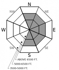
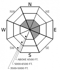
With 3-6 inches of expected new snow accompanied by moderate to strong winds by early next week, fresh wind slabs will develop at mid and upper elevation bands. Don't expect new slabs to bond well to the current surfaces, comprised of facets, surface hoar, and sun crusts. Wind slabs will form on leeward and crossloaded slopes, which include ridgelines, gullies, or alpine bowls. Blowing snow, cornices, and shooting cracks from your skis or board are all sure signs to avoid these affected slopes. If we see more snow than forecast, expect slabs to become more widespread into wind protected terrain.
-
Type ?
-
Aspect/Elevation ?

-
Size ?HistoricVery LargeLargeSmall

Uh oh...the cat is out of the bag. Reports of several D3 size avalanches have trickled in after last week's storm tipped the scale on buried crust layers in some high alpine terrain. Currently, we are expecting thick slabs over faceted crust layers to be most active on the highest, coldest, and most windloaded slopes, the type found in alpine start zones of Glacier National Park or the Flathead Range. Persistent slab avalanches can be hard to predict, break further back than expected, and can be remotely triggered, therefore, avoidance is your best strategy. Staying off, and out from underneath concerning terrain will is your safest bet while our crusty, faceted snowpack takes on more loading this week.
As our previous storm settled out and high pressure sat in, recreationists have begun to push into the mountains skiing, riding, and observing the snowpack. As one forecaster put it, our snowpack has "more crusts than on a Thanksgiving day dessert table." Several iterations of dry weather, rain events, and snow events have made our early season snowpack into a stack of faceted crusts. While the crusts themselves don't pose a threat, once they get buried by a slab, it is time to take heed.
A decent amount of snow fell last Tuesday snow totals ranging from 13 inches in the Whitefish Range to 6 inches by Marias Pass . While we received a handful of avalanche reports involving the new and windblown snow, the most significant avalanche reports came out of the upper elevations in Glacier National Park. Three very large (D3), persistant slab avalanches naturally occured with crowns 3-5 feet deep from high elevations. Check the report here. On some of the uppermost, alpine locations, a thicker slab has been forming over mid-October weak layers without the stabilizing effect of our most recent rain event and subsequent crust.
In the past few days of clear weather, the snow surface has deterioated and become weaker (See this observation and this observation). Depending on your aspect and elevation, surface hoar, near-surface facets, and sun crusts now blanket the snow surface. These layers don't immediately bond well to slabs: stay alert as new snow and winds come in over the next week. As these winds crank up and snow accumulations increase over the weekend, we will have the snow available to transport to form fresh wind slabs. Signs of instability are snow blowing off ridgelines, cornice development, pillows, or shooting cracks. As snow begins to get moved around, it will be interesting to see how our persistant slab problem reacts with an additional load. You can handle this uncertainty by reducing your exposure below alpine start zones and monitoring the structure of the snowpack. If we see more snow than forecasted, watch for storm slabs to develop in wind protected terrain as well.
This is an early season snowpack update. The FAC will continue to monitor conditions through the fall and post updates as conditions warrant. We anticipate daily forecasts and full operations to begin in December.
The NWS is producing automated mountain weather forecasts during the fall season here. We will be producing weather forecasts to accompany daily avalanche forecasts during regular operations.
This forecast applies only to backcountry areas outside established ski area boundaries. The forecast describes general avalanche conditions and local variations always occur. This forecast expires at midnight on the posted day unless otherwise noted. The information in this forecast is provided by the USDA Forest Service who is solely responsible for its content.
Call
Contact
In Partnership With

In Partnership With


