Whitefish Range
Swan Range
Flathead Range and Glacier National Park
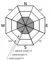
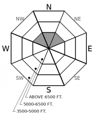
How to read the forecast
Avalanche hazards so far this season are generally localized to high elevation terrain with sufficient snow coverage to ski or ride. With a thin early season snowpack, avalanches can produce harsh consequences if they drag you over rocks, cliffs, or stumps. Pay attention to recent snowfall amounts, wind transport, and underlying weak layers if you are traveling on steep, snow covered terrain.

No Rating
?
Above 6500 ft.
No Rating
?
5000-6500 ft.
No Rating
?
3500-5000 ft.
-
Type ?
-
Aspect/Elevation ?

-
Size ?HistoricVery LargeLargeSmall

Small snow accumulations accompanied by gusty winds are in the forecast for this weekend, with additional snow early next week. Watch for small slabs of wind drifted snow below ridgelines, in crossloaded gullies, or below convexities at high elevations. New and wind transported snow will be accumulating on crusty surfaces which may not bond well immediately. Look for cracking under foot, or dense and thick drifts to identify wind slabs. Consider the consequences of an avalanche, regardless of its size, given the thin coverage right now.
-
Type ?
-
Aspect/Elevation ?

-
Size ?HistoricVery LargeLargeSmall

We have limited observations from the field right now, but early season weather patterns have been conducive to forming persistent slabs on very high elevation slopes, particularly on shaded aspects. In this type of terrain, there is potential to trigger a slab avalanche 1 to 2 feet thick that fails on faceted weak layers on the ground. Pay attention to the snow structure as you gain elevation: dig down to the ground to look for the presence of sugary weak layers before traveling across snow covered slopes. Collapses or shooting cracks are clear signs of an unstable snowpack.
As of October 25th, snow depths around the forecast area range from 10" to 18" at 6,000' (3.5" to 4.5" of Snow Water Equivalent). In most terrain, this has accumulated harmlessly over bare ground and/or consolidated into a thick crust that formed during the past week's warm weather. However, on the highest, coldest slopes, wintry snow may persist, and below it, faceted snow layers that formed earlier in the month (See this observation and this observation). We have limited field observations right now, but it is worth monitoring for persistent slab issues if you are traveling anywhere with a layered snowpack. These instabilities are slow to heal, and could produce avalanches that involve the entire snow depth, up to a couple feet deep. Its easy enough to dig down to the ground right now: look for sugary, faceted snow layers below last weekend's snow. Snow that is well anchored by protruding brush, logs, or talus is genenerally not a concern - terrain that has been smoothed over by windblown or snow accumulations should be treated with suspicion until proven innocent.
The most recent surface crust that formed this week will act as a slick bed surface with the arrival of fresh wind slabs that form this weekend. A series of fronts this weekend will bring modest snow accumulations and strong winds that shift from the Northwest to the East. Watch for new windblown snow to form small but easily triggered slabs in leeward terrain that has existing smooth snow coverage. These slabs will gradually heal into the early work week as time passes and winds are forecasted to subside. We may see another pulse of snow and strong winds again early next week to refresh the problem. Remember that any avalanche, large or small, can have harsh consequences if it drags you over rocks, over cliffs, or into trees or stumps.
The FAC will monitor conditions through the fall and post updates as conditions warrant. We anticipate daily forecasts and full operations to begin in December.
Now is the time to get your gear dialed and brush up on your avalanche knowledge. The 2019 Northern Rockies Snow and Avalanche Workshop has a great lineup of presentations, vendor booths, raffles, and an all-around good time. The event is November 16th, 2019...all the details are here. Registration is open! Stay tuned for our upcoming avalanche class schedule later this fall.
The NWS is producing automated mountain weather forecasts during the fall season here. We will be producing weather forecasts to accompany daily avalanche forecasts during regular operations.
This forecast applies only to backcountry areas outside established ski area boundaries. The forecast describes general avalanche conditions and local variations always occur. This forecast expires at midnight on the posted day unless otherwise noted. The information in this forecast is provided by the USDA Forest Service who is solely responsible for its content.
Call
Contact
In Partnership With

In Partnership With


