| Wednesday | Wednesday Night | Thursday | |
|---|---|---|---|
| Cloud Cover: | Partly Cloudy | Mostly Cloudy | Partly Cloudy |
| Temperatures: | 31 to 36 deg. F. | 25 to 30 deg. F. | 31 to 36 deg. F. |
| Wind Direction: | East | Northeast | Northeast |
| Wind Speed: | 10 to 15, gusting to 30 | 15 to 20, gusting to 40 | 10 to 15, gusting to 35 |
| Snowfall: | 0 in. | 0 in. | 0 in. |
| Snow Line: | 3500 | 3500 | 3000 |
Whitefish Range
Swan Range
Flathead Range and Glacier National Park
How to read the forecast
Natural and triggered wet snow avalanches are unlikely so long as the crust of refrozen snow at or just below the snow surface remains intact. If you're experiencing loud, teeth-chattering skiing or having trouble sidehilling, the potential for wet snow avalanches is low. Once warming temperatures and direct sun degrade this crust, start looking for an exit to colder, lower angled terrain.

1. Low
?
Above 6500 ft.
2. Moderate
?
5000-6500 ft.
1. Low
?
3500-5000 ft.
- 1. Low
- 2. Moderate
- 3. Considerable
- 4. High
- 5. Extreme
-
Type ?
-
Aspect/Elevation ?

-
Likelihood ?CertainVery LikelyLikelyPossible
 Unlikely
 -
Size ?HistoricVery LargeLargeSmall

As refrozen snow near the snow surface softens, the potential for triggered wet loose avalanches will rise. Most of today's weather factors are conspiring to keep that crust intact: cold temperatures this morning, increasing cloud cover and easterly winds, and a little new snow to reflect incoming radiation. If, however, you encounter mushy, wet snow, avoid riding on or below steep slopes. The most dangerous slopes will be those where you can punch through the crust to unconsolidated, mushy snow near the ground. Step off your skis or sled where you feel the snow surface softening. If you drop down to above your knees, head to colder, lower-angled terrain. Triggered wet loose slides in these conditions can entrain dangerous amounts of debris that is very difficult to escape.
-
Type ?
-
Aspect/Elevation ?
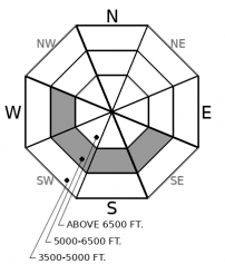
-
Likelihood ?CertainVery LikelyLikelyPossible
 Unlikely
 -
Size ?HistoricVery LargeLargeSmall

After several days of cooler temperatures and a decent refreeze last night, wet slab and glide avalanches have grown unlikely. They are confined to a few steep slopes where a shot of meltwater might weaken faceted snow buried deep in the snowpack. Without X-Ray goggles, it's impossible to tell if these conditions are developing. Minimize your exposure to this isolated hazard by traveling early, avoiding slopes below glide cracks and steep, rocky, sun-baked terrain. If you step off your skis or sled and sink to your waist, you have definitely overstayed your welcome in steep terrain.
The water factory at the snow surface has shutdown, thanks to clouds and fog Tuesday and 5 to 24 hours of freezing temperatures. The wet snow avalanche hazard has diminished. Below Tuesday's trace to 2 inches of new snow is a supportable crust of refrozen snow. On shaded, mid- and upper-elevation slopes, this crust is unlikely to soften today. Without another shot of meltwater, wet snow avalanches are unlikely in this terrain. You won't find wet snow that will release as rollerballs and sluffs on steep slopes, and weak layers deeper in the snowpack won't weaken without meltwater percolating down from the surface.
It's a different story on steep, mid-elevation slopes that recieve direct sun. In this terrain, last week's pulse of meltwater was larger and more sustained. It's left the snowpack below the surface crust an uncosolidated pudding of coarse, melt-freeze grains that feels like a slushie with after the food coloring has drained out. Wet snow avalanches won't pose a hazard on these slopes until the crust breaks down, though once it does, triggered wet loose avalanches can quickly entrain dangerous amounts of debris.
The most dangerous slopes are those that are somewhere in between those two. That is, slopes where the snowpack remains layered and a pulse of meltwater can weaken old weak layers, producing wet slab avalanches. These are most likely to be mid to upper elevation slopes that tip just east and west of due south. They'll be slopes with a wet snow surface but that still mostly support your weight or the weight of your snowmachine. Often they'll have cliffs or rockbands above them, where melting snow can run deep into the snowpack on the slopes below. While these conditions are unlikely today, the hair on your neck should go up if you do find them. Scurry back to lower-angled slopes that are free from overhead hazards.
EDUCATION: The Scoop on Spring Touring: Curious about spring snow and safe travel techniques? This is the talk for you. Join FAC Lead Forecaster Blase Reardon for a FREE one hour talk on spring conditions in the Flathead. The talk begins at 6:30 p.m. Thursday, April 11th at Rocky Mountain Outfitters in Kalispell. That evening is also a community night for the Friends of the Flathead Avalanche Center at Sweet Peaks in Kalispell. Stop by for a sweet treat and then head down the street to get the scoop on spring conditions.
This morning's clear skies will give way to increasing clouds as clouds sweeps in from the south. Sadly, most of the moisture and snow will remain south of the forecast region. Winds veer easterly and become moderate with strong gusts this afternoon.
This forecast applies only to backcountry areas outside established ski area boundaries. The forecast describes general avalanche conditions and local variations always occur. This forecast expires at midnight on the posted day unless otherwise noted. The information in this forecast is provided by the USDA Forest Service who is solely responsible for its content.


