| Wednesday | Wednesday Night | Thursday | |
|---|---|---|---|
| Cloud Cover: | Mostly Cloudy | Partly Cloudy | Mostly Cloudy |
| Temperatures: | 24 to 28 deg. F. | 12 to 18 deg. F. | 25 to 30 deg. F. |
| Wind Direction: | Northeast | West | Southwest |
| Wind Speed: | 9mph gusting to 20 | around 6mph | 10mph gusting to25 |
| Snowfall: | 1" to 3" in. | 0" in. | 0" in. |
| Snow Line: | 2000' | 1500' | 1000' |
Flathead Range and Glacier National Park
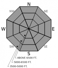
How to read the forecast
New slabs may bond poorly to the underlying snow. Use caution on slopes steeper than about 35 degrees. Track new snow totals and look for recently drifted snow. Slabs thicker than about 8” can be dangerous. Exercise caution below ridgelines and near crossloaded features. Choose simpler, sheltered terrain to avoid the problem.

2. Moderate
?
Above 6500 ft.
2. Moderate
?
5000-6500 ft.
2. Moderate
?
3500-5000 ft.
- 1. Low
- 2. Moderate
- 3. Considerable
- 4. High
- 5. Extreme
-
Type ?
-
Aspect/Elevation ?

-
Likelihood ?CertainVery LikelyLikelyPossible
 Unlikely
 -
Size ?HistoricVery LargeLargeSmall

Keep it simple today. Up to 6 inches of new snow has fallen and drifted onto a variety of weak surfaces. Crusts, facets, and surface hoar that developed over the weekend can inhibit the bonding process. Expect slabs to be more dangerous where the most snow has accumulated. On steep slopes near and above treeline, watch for shooting cracks as red flags. Use extra caution on easterly slopes where recent drifting has deposited the thickest slabs. Opt for lower-angled, sheltered terrain. Avoid riding above terrain traps where even smaller avalanches will have increased consequences. Watch for overhead hazards in bigger terrain where slides can run further downhill.
Up to 12” of new snow fell overnight, with an additional few inches expected today. Shifting winds have trended down overnight, but were strong enough to drift snow into cohesive slabs through yesterday afternoon. We were able to trigger a small wind slab at middle elevations in the Jewel Basin yesterday.
New slabs have developed on top of a variety of weak snow surfaces. Observers Monday found facets, crusts, and surface hoar across the area. New snow may bond poorly to these layers and be sensitive to the weight of a rider or snow machine. Expect slabs to be larger and more dangerous where they are thickest. The Swan and Whitefish Ranges have received the most new loading. Noisy Basin is reporting 1.4” of SWE and Big Mountain reporting 0.9” as of 5am. Stations near the Divide are showing up to 6" of new snow. Southwest winds transported some of that load onto easterly slopes into the early evening. With few instruments in the northwest Flathead Range, there is some uncertainty about just how much snow accumulated west of Essex.
Be especially cautious below ridgelines and near crossloaded features at middle and upper elevations. Terrain features that stress the snowpack – convexities, unsupported slopes, and slopes steeper than about 35 degrees – are the most concerning. Opt for lower-angled, sheltered slopes for the safest and best conditions.
This forecast applies only to backcountry areas outside established ski area boundaries. The forecast describes general avalanche conditions and local variations always occur. This forecast expires at midnight on the posted day unless otherwise noted. The information in this forecast is provided by the USDA Forest Service who is solely responsible for its content.


