| Sunday | Sunday Night | Monday | |
|---|---|---|---|
| Cloud Cover: | Mostly clear | Partly Cloudy | Mostly clear |
| Temperatures: | 23 to 28 deg. F. | 4 to 9 deg. F. | 25 to 30 deg. F. |
| Wind Direction: | Southwest | Southwest | Southwest |
| Wind Speed: | 5 to 10 mph, gusting to 20 | 5 to 15 mph, gusting to 25 | 10 to 20 mph, gusting to 30 |
| Snowfall: | 0" in. | 0" in. | 0" in. |
| Snow Line: | 0' | 0' | 0' |
Whitefish Range
Swan Range
Flathead Range and Glacier National Park
How to read the forecast
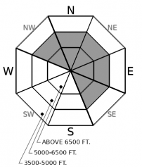
Mild weather is strengthening recently formed slabs but yesterday's skier triggered slides confirm that areas of unstable snow exist. Today’s clear conditions will allow for great visibility of wind drifted snow. Look for areas where slabs are thickest and most dangerous: below leeward ridgelines/saddles and in cross-loaded gullies. Seek out softer and safer snow in terrain sheltered from the wind.

2. Moderate
?
Above 6500 ft.
1. Low
?
5000-6500 ft.
1. Low
?
3500-5000 ft.
- 1. Low
- 2. Moderate
- 3. Considerable
- 4. High
- 5. Extreme
-
Type ?
-
Aspect/Elevation ?

-
Likelihood ?CertainVery LikelyLikelyPossible
 Unlikely
 -
Size ?HistoricVery LargeLargeSmall

After nearly a month of cold northeast winds, relatively warm southwest winds returned to our area Thursday accompanied by several inches of snow except for the Swan Range which received 7" to 12". Resulting slabs formed on leeward terrain features and were reactive to the weight of skiers Thursday and Friday. Slabs are slowly strengthening but remain a concern as evidenced by two triggered slides in the Middle Fork Friday. Continue to utilize safe travel protocols in steep cross-loaded gullies and on the leeward sides of ridgelines. Steer around snow that feels dense, has a textured look or is cracking under your feet or machine.
2 skier triggered slides in the Flathead Range yesterday confirm that instabilities in recently formed thicker slabs have not completely healed. One slide was intentionally triggered by the third skier on the slope who skied across the corner of a convexity. This slab was formed by Thursday's southwest winds and occurred on a steep upper elevation north slope. The second slide was accidentally triggered on an older wind slab formed by northeast winds earlier in the week and occurred on a steep mid-elevation northwest slope.
Wind slabs have been our sole avalanche problem over the past few days and were formed by snow and warm southwest winds Thursday. Thicker slabs formed in the Swan Range, which received 7” to 12” of snow, and in the higher elevations of the Whitefish Range, the Flathead Range and Glacier Park. Easily triggered wind slabs were reported Thursday (example A, example B) with signs of strengthening slabs observed Friday (example 1, example 2). Temperatures continue to run 10+ degrees below normal but it feels like a heatwave after a month of Arctic cold. Warm dry conditions are allowing slabs to strengthen as observed Saturday in several observations including this one from the Tunnel/Paola area. With great visibility, signs of wind affected snow should be easy to identify today. Look for scouring on the south and west sides of ridgelines with subsequent pillows and textured snow on the leeward terrain. Hand pits are a useful tool to use to determine the bonding of the slab to the old snow beneath.
High pressure is building over our area with mostly clear skies, light winds and warmer temperatures today and Monday.
This forecast applies only to backcountry areas outside established ski area boundaries. The forecast describes general avalanche conditions and local variations always occur. This forecast expires at midnight on the posted day unless otherwise noted. The information in this forecast is provided by the USDA Forest Service who is solely responsible for its content.


