| Saturday | Saturday Night | Sunday | |
|---|---|---|---|
| Cloud Cover: | Mostly cloudy | Partly Cloudy | Mostly clear |
| Temperatures: | 20 to 25 deg. F. | 4 to 9 deg. F. | 23 to 29 deg. F. |
| Wind Direction: | Southwest | Southwest | Southwest |
| Wind Speed: | 5 to 15 | 5 to 15 | 5 to 15 |
| Snowfall: | 0" in. | 0" in. | 0" in. |
| Snow Line: | 0' | 0' | 0' |
Swan Range
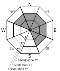
How to read the forecast

2. Moderate
?
Above 6500 ft.
2. Moderate
?
5000-6500 ft.
1. Low
?
3500-5000 ft.
- 1. Low
- 2. Moderate
- 3. Considerable
- 4. High
- 5. Extreme
-
Type ?
-
Aspect/Elevation ?

-
Likelihood ?CertainVery LikelyLikelyPossible
 Unlikely
 -
Size ?HistoricVery LargeLargeSmall

7" to 12" of snow on Thursday accompanied by gusty southwest winds formed thicker wind slabs on leeward terrain features. Observers on Thursday and Friday reported easily triggered slabs and shooting cracks in areas where winds had thickened the recent snow. Although they are becoming less reactive now, wind slabs remain a concern at mid and upper elevation terrain. Be cautious of downwind terrain features below ridges and in cross-loaded gullies. Take heed of cracking or thick-feeling snow as a warning sign to move towards more wind protected or wind scoured terrain.
There are a lot of slopes offering good, stable riding today, but trouble is still lurking in terrain with thicker drifts. The most suspect areas are those that saw a combination of more snow and more wind on Thursday - either high alpine terrain near the crests of the Flathead and Whitefish Ranges, or in the Swan Range snow belt. The Swan Range reported 7" to 12" through the day on Thursday, while the Flathead Range and Whitefish Ranges saw a few inches or less. Southwest winds increased through the day and overnight on Thursday, and observers reported easily triggered wind slabs breaking in freshly drifted areas (example A, example B). Milder weather since yesterday morning is allowing these instabilities to gain strength, especially in areas where slabs are thin and quicker to heal. In terrain that saw minimal or no wind drifting, you'll find generally stable conditions (example A, example B). Wind slabs will be slowest to gain strength in areas with the thickest drifts. These are commonly below alpine ridgelines, or downwind of passes and saddles where the winds have larger fetches to collect and deposit the snow into larger slabs. Pay attention to subtle differences in wind drifting and bonding of these recently formed slabs, and you'll have a trouble-free day in the mountains.
A quiet day in the weather is on tap for today: light winds and no accumulating snow. Clouds start to break up overnight and we'll see sunny weather by tomorrow.
This forecast applies only to backcountry areas outside established ski area boundaries. The forecast describes general avalanche conditions and local variations always occur. This forecast expires at midnight on the posted day unless otherwise noted. The information in this forecast is provided by the USDA Forest Service who is solely responsible for its content.


