| Friday | Friday Night | Saturday | |
|---|---|---|---|
| Cloud Cover: | Mostly Cloudy | Mostly Cloudy | Mostly Cloudy |
| Temperatures: | 19 to 26 deg. F. | 5 to 12 deg. F. | 19 to 25 deg. F. |
| Wind Direction: | West-southwest | West-southwest | West-southwest |
| Wind Speed: | 8 to 13, gusting to 25 | 5 to 10, gusting to 20 | 5 to 10 |
| Snowfall: | 0 to 1" in. | 0" in. | 0" in. |
| Snow Line: | 500' | 0' | 0' |
Whitefish Range
Flathead Range and Glacier National Park
How to read the forecast
Stick to wind-sheltered slopes with no fresh drifts today; freshly-formed slabs of wind-blown snow are proving surprisingly reactive. They can be dangerous where they're thicker than about 6 inches, or above terrain traps. These slabs are larger and more widespread at upper elevations. Cracks shooting away from your snowmobile, snowboard or skis are warning signs of this danger. Slopes where the surface snow has not been disturbed by the wind offer great riding with fewer booby traps today.

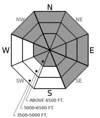
3. Considerable
?
Above 6500 ft.
2. Moderate
?
5000-6500 ft.
1. Low
?
3500-5000 ft.
- 1. Low
- 2. Moderate
- 3. Considerable
- 4. High
- 5. Extreme
-
Type ?
-
Aspect/Elevation ?

-
Likelihood ?CertainVery LikelyLikelyPossible
 Unlikely
 -
Size ?HistoricVery LargeLargeSmall

Where you find fresh slabs of drifted snow, they’ll be sensitive to your weight or the weight of your snowmobile. On steep slopes with recent wind loading, you can trigger slabs that break 6 to 18 inches deep. That’s enough snow to be dangerous, especially above terrain traps like gullies or trees. Clues to this danger include shooting cracks, a rippled snow surface, and dense snow that feels like flour or feels hollow. You’ll find these slabs on lee slopes near ridges, crossloaded into gullies at lower elevations. Avoid riding on or under steep slopes when you see snow blowing around in start zones.
Yesterday, it didn’t take long for southwesterly winds to produce small but surprisingly sensitive wind slabs. Erich triggered one by whacking a slope with a shovel. These slabs were soft and not particularly dangerous, at least on small test slopes that weren’t above terrain traps. Great footage of that in Zach's video. They broke on low-density snow that fell before the winds picked up. The slabs were widespread in drainages that funneled the southwest winds: Doris Creek on the lee side of the Swan Crest, and Skiumah Creek on the lee side of the Flathead Range. Areas that didn’t see sustained winds, like Mt. Furlong in John Stevens Canyon, saw limited drifting and slab development.
The southwest winds continued to blow overnight, peaking early evening. I expect winds slabs to have grown thicker and wider overnight, and to remain reactive today. With winds veering to the west, some new slabs may form on slopes that haven’t already been loaded. Expect some variability in slab distribution, as drainage-specific terrain funnels winds, forming slabs at higher or lower elevations, or crossloads different aspects. New snow accumulations in the Swan Range (7-10") are greater than in other ranges. An older generation of wind slabs, formed by easterly winds, is showing few signs of instability. Check upper elevation, westerly slopes for these firm leftovers before you commit to steep terrain there.
Regardless of where you ride today, keep these thoughts in mind: While there’s not that much snow available for the winds to blow around, it’s proving surprisingly reactive where it has drifted. Be picky as a toddler when choosing your ascent and descent lines today.
Unstable but not very moist air today. Expect snow showers with gusty winds. Wind directions may veer more to the west.
This forecast applies only to backcountry areas outside established ski area boundaries. The forecast describes general avalanche conditions and local variations always occur. This forecast expires at midnight on the posted day unless otherwise noted. The information in this forecast is provided by the USDA Forest Service who is solely responsible for its content.


