| Thursday | Thursday Night | Friday | |
|---|---|---|---|
| Cloud Cover: | Mostly Cloudy | Mostly Cloudy | Mostly Cloudy |
| Temperatures: | 23 to 28 deg. F. | 8 to 15 deg. F. | 19 to 25 deg. F. |
| Wind Direction: | Southwest | Southwest | Southwest |
| Wind Speed: | 10 to 15m gusting to 30 | 15 to 20, gusting to 35 | 10 to 15, gusting to 25 |
| Snowfall: | 1 to 6 in. | 0" in. | 0" in. |
| Snow Line: | 1500' | 500' | 0' |
Whitefish Range
Swan Range
Flathead Range and Glacier National Park
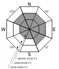
How to read the forecast
Good riding and safe riding are aligned today. Find well-supported slopes sheltered from the wind, and you'll get both. Small, freshly-formed slabs of drifted snow will pose a danger on steep, easterly slopes that collect blowing snow. Avoid these, along with lens- and whale-shaped drifts that are leftovers from recent bouts of easterly winds.

2. Moderate
?
Above 6500 ft.
1. Low
?
5000-6500 ft.
1. Low
?
3500-5000 ft.
- 1. Low
- 2. Moderate
- 3. Considerable
- 4. High
- 5. Extreme
-
Type ?
-
Aspect/Elevation ?

-
Likelihood ?CertainVery LikelyLikelyPossible
 Unlikely
 -
Size ?HistoricVery LargeLargeSmall

Freshly drifted slabs of snow may be sensitive to a person’s weight on good old-fashioned easterly aspects this afternoon, with a few pockets of slab on westerly slopes from Wedesday's winds. These recent slabs will be larger at upper elevations, where more snow is available for transport. Look for snow drifted in to the tops of chutes, in the lee sides of gullies, and downwind of saddles and other features that channel southwesterly winds. This hazard will grow more widespread after noon, when wind speeds pick up. Continue to steer clear of harder slabs leftover from recent bouts of easterly winds that are crossloaded into gullies and across open, alpine bowls.
9:00 AM update: Many sites have already picked up 1-2" of low-density snow. If snowfall continues and accumulations exceed forecasts, expect larger and more widespread Wind Slab avalanche danger.
Ah, the good ole days: grey skies, snow showers, winds stronger at upper elevations and blowing from the southwest. We’ve seen little of that classic Flathead weather for the past five weeks. It’s back now, and with it comes a shift in where avalanche hazards are most widely distributed and most sensitive to a person’s weight.
Expect a fresh batch of wind slabs on easterly slopes this afternoon. These aren’t likely to bond well with old snow surfaces, many of which are firm, faceting, or both. Fresh slabs will be largest downwind of broad, open slopes, which provide the best fetch for winds to collect snow. They’ll generally be soft, and cracking around your board or sled is good sign they are sensitive to your weight on steep slopes. Sun crusts on windward slopes at mid-elevations should limit the amount of snow available for transport at that elevation, though you might find a few fresh slabs in terrain prone to collecting drifted snow, like the tops of leeward chutes and start zones below ridges.
Then there are the slabs leftover from the recent bout of easterly winds. These will be on exactly the opposite aspects – westerly slopes – and they exist at both mid and upper elevations. Human-triggered slides involving these slabs have occurred regularly the past week: Tuesday above Dickey Lake, Monday on Sheep Mountain, and Sunday on Mt. Brown and in Wahoo Creek. While we've had no reports from the Swan Range, conditions there are likely similar. The leftover slabs that remain unstable are harder and more prone to break above you, so consequences of triggering them have not diminished. Avoid this nagging danger by avoiding dense, lens-shaped drifts on steep terrain.
Today's southwest flow favors the Swan Range, and the range-specific forecast calls for 3 to 9 inches of new snow. If that verifies, the Wind Slab avalanche problem will be more widespread at mid-elevations. Slabs will also be thicker and potentially more dangerous.
Strong but relatively dry southwest flow will bring warmer temperatures, moderate to strong southwesterly winds, and snow showers. Most areas will see just a few inches of snow. The Swan Range could see 6 inches or more.
This forecast applies only to backcountry areas outside established ski area boundaries. The forecast describes general avalanche conditions and local variations always occur. This forecast expires at midnight on the posted day unless otherwise noted. The information in this forecast is provided by the USDA Forest Service who is solely responsible for its content.


