| Monday | Monday Night | Tuesday | |
|---|---|---|---|
| Cloud Cover: | Clear | Mostly clear | Clear |
| Temperatures: | 5 to 10 deg. F. | -10 to 0 deg. F. | 15 to 25 deg. F. |
| Wind Direction: | Northeast | Northeast | Northeast |
| Wind Speed: | 5 to 10 mph | 5 to 10 mph | 5 to 10 mph |
| Snowfall: | 0" in. | 0" in. | 0" in. |
| Snow Line: | 0' | 0' | 0' |
Whitefish Range
Swan Range
Flathead Range and Glacier National Park
How to read the forecast

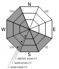
2. Moderate
?
Above 6500 ft.
2. Moderate
?
5000-6500 ft.
1. Low
?
3500-5000 ft.
- 1. Low
- 2. Moderate
- 3. Considerable
- 4. High
- 5. Extreme
-
Type ?
-
Aspect/Elevation ?

-
Likelihood ?CertainVery LikelyLikelyPossible
 Unlikely
 -
Size ?HistoricVery LargeLargeSmall

The recent Arctic wind event has ended resulting in slabs found in unusual locations. Up to a foot of low-density snow from Friday's storm redistributed by northeast winds has produced a handful of natural and human triggered wind slabs in the past few days. Slabs are resting on a variety of surfaces that are inhibiting bonding with continued cold weather slowing the strengthening process. Areas harboring wind slabs will have a textured surface, feel noticeably denser, possibly hollow sounding with cracking and shooting cracks a sign of instability. Higher quality snow and safer avalanche conditions are found in areas sheltered from the wind.
With decreasing winds, sunshine and slightly warmer temperatures observations of the recent Arctic wind event are trickling in. Natural wind slab avalanches have been noted in Cascadilla Creek and on Mt Brown with intentionally triggered slides on Mt Brown and in Wahoo Creek. On Mt Brown, I noticed slabs on southeast through northwest aspects that were generally firm (4F to 1F hard) and not adhering to the underlying low-density snow, sun crust, or firm wind-packed surface. Continued cold weather is slowing the strengthening process with these slabs. We have dropped the low-elevation danger rating to LOW but realize that slabs exist at this elevation but are isolated in distribution.
On slopes not affected by winds, the danger will generally be LOW. In this terrain, last weeks low-density snow is slowly settling out and providing safer and more enjoyable riding conditions.
We have removed the Persistent Slab problem from our list of current avalanche problems due to not seeing or hearing about signs of instability in over a week, we are currently in a benign weather pattern and the slab is starting to decay in the shallowest/most suspect areas due to the recent cold snap.
Another beautiful but cold day on tap as an arctic air mass remains in our area. Sunshine, well below normal temperatures, and light winds are expected today and tomorrow.
This forecast applies only to backcountry areas outside established ski area boundaries. The forecast describes general avalanche conditions and local variations always occur. This forecast expires at midnight on the posted day unless otherwise noted. The information in this forecast is provided by the USDA Forest Service who is solely responsible for its content.


