| Saturday | Saturday Night | Sunday | |
|---|---|---|---|
| Cloud Cover: | Overcast | Mostly cloudy | Partly cloudy |
| Temperatures: | 12 to 23 deg. F. | -8 to 0 deg. F. | 6 to 16 deg. F. |
| Wind Direction: | Southwest to Northeast | Northeast | Northeast |
| Wind Speed: | 10 to 15, gusting to 30 | 15 to 20, gusting to 30 | around 15, gusting to 25 |
| Snowfall: | 1 in. | 0 in. | 0 in. |
| Snow Line: | 0 | 0 | 0 |
Whitefish Range
How to read the forecast
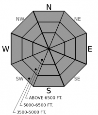
Up to a foot of new snow and changing winds are creating obvious instabilities on the snow surface. Expect drifts that can break up to a foot or more deep on steep, leeward slopes. Watch for blowing snow and cracking in denser snow as red flags. Less obvious is the continuing threat of persistent slab avalanches. Choose lower angled terrain that is planar, or concave, and has uniform snow cover to reduce your risk to this dangerously large problem.

3. Considerable
?
Above 6500 ft.
3. Considerable
?
5000-6500 ft.
2. Moderate
?
3500-5000 ft.
- 1. Low
- 2. Moderate
- 3. Considerable
- 4. High
- 5. Extreme
-
Type ?
-
Aspect/Elevation ?

-
Likelihood ?CertainVery LikelyLikelyPossible
 Unlikely
 -
Size ?HistoricVery LargeLargeSmall

Sensitive new drifts will develop on all aspects as a result of changing winds throughout the day. Mark found recent wind slabs that were already reactive yesterday in Skiumah. In the Whitefish Range yesterday, I found propagating failures under older, stiffer wind deposits. As winds change to the northeast and increase today, they will have ample snow to blow around. The top of Big Mountain is reporting a foot of new, low density snow this morning for shifting winds to play with. Blowing snow below ridgelines and on crossloaded features will point to the newest slabs. Cracking in denser surface snow is a red flag. Better and safer riding will be found in sheltered terrain.
-
Type ?
-
Aspect/Elevation ?

-
Likelihood ?CertainVery LikelyLikelyPossible
 Unlikely
 -
Size ?HistoricVery LargeLargeSmall

Collapses, propagating test results, and human triggered avalanches over the past week demonstrate that thick slabs can still fail on persistent weak layers. The source of the problem is usually a faceted crust that was buried on the 2nd. That layer is now covered by 2 to 4 feet of denser snow. Because these instabilities are not widespread, and do not give consistent feedback, they can be difficult to assess. Snow pit tests are useful, but are not a silver bullet and may not give you clear results. Choosing simple terrain with a uniform snow cover is a better way manage the problem. Avoid convexities and areas where the snowpack is shallowest. Whumpfs and shooting cracks should point you toward lower-angled, lower consequence terrain.
As of early this morning, Big Mountain is reporting a foot of new snow. Noisy Basin is reporting 4", and stations near the Divide are showing 3" of new snow. Shifting winds over the past few days have left small drifts on many aspects. Mark found wind slabs yesterday that were reactive enough to collapse under his skis and send shooting cracks up to 10 feet across. There is still ample low density snow for the fickle winds to blow around. Blowing snow from southwest, and then northeast, winds will be important to note today. Unusually, winds may be stronger or more sustained at middle and lower elevations. Don’t let low elevation drifts catch your off guard. In areas with 8" or more of new snow, watch for sluffing in steep, sheltered terrain.
Over the past week, persistent slab avalanches have been triggered across the Whitefish Range. Most recently, on the 20th, a skier was almost taken for a dangerous ride near Red Meadow. On the 17th, snowmobilers triggered several persistent slab avalanches near Graves Creek. And on the 15th, a skier remotely triggered a large persistent slab avalanche near WMR. Most of these avalanches failed in weak facets surrounding the Groundhog crust. We saw failures around the crust yesterday in snowpack tests near Werner Peak. Reports of this kind of activity in the Swan and Flathead Ranges are limited. But Mark recently documented some impressive persistent slab avalanches that ran during the last avalanche cycle in the Flathead Range, which shows that the weak snowpack structure still exists – it may just be harder to trigger. Little feedback from deeply buried weak layers adds uncertainty to your hazard analysis. Snowpack tests can help you identify the instability, but the problem varies across the terrain. Choosing low-angled, planar or concave slopes with good anchoring is a safer bet when managing this tricky problem. Look for areas with uniform snow cover; shallow spots are likely trigger points.
The overnight snowfall is beginning to taper off this morning. West winds gusting to 20 mph this morning will be replaced by northeast winds gusting to 25 mph this afternoon.
This forecast applies only to backcountry areas outside established ski area boundaries. The forecast describes general avalanche conditions and local variations always occur. This forecast expires at midnight on the posted day unless otherwise noted. The information in this forecast is provided by the USDA Forest Service who is solely responsible for its content.


