| Monday | Monday Night | Tuesday | |
|---|---|---|---|
| Cloud Cover: | Overcast | Overcast | Overcast |
| Temperatures: | -10 to 0 deg. F. | -10 to 0 deg. F. | 0 to 10 deg. F. |
| Wind Direction: | East | East | Northeast |
| Wind Speed: | 10 to 20 mph, gusting to 30 | 10 to 20 mph, gusting to 30 | 10 to 15 mph, gusting to 25 |
| Snowfall: | 1 to 3 in. | 0 in. | 0 in. |
| Snow Line: | 0 ft | 0 ft | 0 ft |
Whitefish Range
Swan Range
How to read the forecast
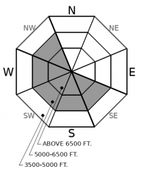
Bitterly cold temperatures and breezy northerly winds are forming cold stiff slabs on atypical leeward aspects. Slabs are forming below ridgelines and in cross-loaded gullies on surfaces which may inhibit bonding. It remains possible for buried weak layers to become reactive as wind-deposited snow accumulates or from small wind slab avalanches. Expect to encounter hollow sounding snow which is a red flag that you are on a slab. Areas sheltered from the wind offer a safer alternative.

3. Considerable
?
Above 6500 ft.
2. Moderate
?
5000-6500 ft.
1. Low
?
3500-5000 ft.
- 1. Low
- 2. Moderate
- 3. Considerable
- 4. High
- 5. Extreme
-
Type ?
-
Aspect/Elevation ?

-
Likelihood ?CertainVery LikelyLikelyPossible
 Unlikely
 -
Size ?HistoricVery LargeLargeSmall

Moderate to strong north-east winds formed cold stiff slabs on atypical (westerly) aspects at mid and upper elevations beneath ridgelines and on cross-loaded features such as gullies. Slabs may be found lower on a slope than anticipated due to the strong winds and have formed on a variety of surfaces including crusts, loose snow, surface hoar and facets which may inhibit bonding. Expect these slabs to be denser and stiffer than usual, which means they could propagate surprisingly wide or give poor feedback underfoot. The best tactic, then, is looking for drifting patterns and steer around denser, hollow sounding snow. Hollow sounding snow is a telltale sign that you are on a dense slab overlying less dense snow. Safer conditions and higher quality snow will be found in areas sheltered from the wind.
-
Type ?
-
Aspect/Elevation ?

-
Likelihood ?CertainVery LikelyLikelyPossible
 Unlikely
 -
Size ?HistoricVery LargeLargeSmall

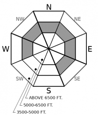
Observations Saturday reiterate that our Persistent Slab problem is alive and kicking. Direct feedback such as collapsing and shooting cracks is waning but surface hoar and facets buried 1-2' below the surface remain reactive in stability tests. It remains possible for a small wind slab avalanche, or a rider, to initiate a Persistent Slab avalanche. Areas of greatest concern are steep, mid-elevation slopes open to the sky where surface hoar and facets likely developed. This problem can often be identified by hand shear tests with shooting cracks and collapsing signs of instability. Remain cognizant of this problem while descending through the middle elevation band, especially above terrain traps.
Bitterly cold and windy weather entered our area late Saturday night plummeting temperatures well below zero for the past 24 - 30 hours at ridgeline weather stations. The area between Essex and Marias Pass is the coldest location with the Snowslip weather station (7000') reporting -28 for the past 6 hours with valley floor locations (Fielding 4500') reporting -15. Winds have been steady out of the NNE with WMR averaging 15-22 mph with gusts of 21-36 mph for the past 22 hours and Snowslip regaining its spot atop the podium with a 22-30 mph average and 30-38 mph gusts these past 7 hours. "How about them apples"!
Due to the severe windchill, we have no observations from Sunday to supplement our forecasted danger ratings. Therefore, we are left to make assumptions with low confidence. We are assuming that most of the snow available for transport from NNE winds prior to the Arctic intrusion is long gone. Winds for the initial 6 hours of this Arctic intrusion were impressive at all ridgeline weather stations resulting in the stripping of the available snow. The combination of moderate to strong NNE winds and cold temperature has formed cold slabs. Cold slabs create stiff slabs and stiff slabs bridge the weight of a rider over a wider area better than soft slabs. In other words, the deformation of the snowpack from a rider does not penetrate as deeply to a cold slab as a warm one. Unfortunately, this is a double-edged sword due to triggered slides propagating further than what one expects from a soft "warm" slab. I will reiterate what was said yesterday...Unusual weather produces unusual avalanche activity and today might be one of those days... Slabs on atypical aspects, wind-deposited snow further down the slope than anticipated, new low-density snow not adhering to surface crusts. A good day to enjoy riding lower consequential terrain out of the wind.
It has been nearly 2 weeks since we first listed Persistent Slab as an avalanche problem on January 23. Observations of avalanches, shooting cracks, collapses and ECTP results on the buried January 17 weak layers have been reported almost entirely on NW - SE aspects. This information enabled us to paint a west - southeast distribution rose. Exceptions and outliers are always possible and this weekend an avalanche course at WMR had multiple ECTP results on an SW aspect at 6400’. We appreciate receiving observations.such as these which help us to improve our product!
The Persistent Slab problem remains alive and well with surface hoar and facets buried 1-2' deep reactive in snowpit stability tests and in hand shear tests Saturday in Noisy Basin and Canyon Creek. The warming event Saturday moistened the snow surface upwards of 6000' which has now been "locked up" due to the cold temperatures. This will inhibit Persistent Slab avalanche activity but a wind slab avalanche, or a rider hitting the "sweet" spot, has the potential to trigger a Persistent Slab avalanche throughout the middle elevation band.
EDUCATION: Sign up for one of our upcoming classes: Companion Rescue Clinic 02/09/2019 and Introduction to Avalanches (non-motorized) 02/28/2019 to 03/02/2019.
An arctic air mass continues to spill across the Divide and push south and west today. Expect much colder temperatures, strong easterly winds, and dangerously cold wind chill.
This forecast applies only to backcountry areas outside established ski area boundaries. The forecast describes general avalanche conditions and local variations always occur. This forecast expires at midnight on the posted day unless otherwise noted. The information in this forecast is provided by the USDA Forest Service who is solely responsible for its content.


