| Thursday | Thursday Night | Friday | |
|---|---|---|---|
| Cloud Cover: | Mostly cloudy | Partly cloudy | Partly cloudy |
| Temperatures: | 27 to 32 deg. F. | 20 to 25 deg. F. | 30 to 35 deg. F. |
| Wind Direction: | Southwest | Southwest | Southwest |
| Wind Speed: | 10 to 15 mph, gusting to 35 | 15 to 20 mph, gusting to 35 | 10 to 15 mph, gusting to 30 |
| Snowfall: | 0 in. | 0 in. | 0 in. |
| Snow Line: | 3000 ft | 4000 ft | 4000 ft |
Flathead Range and Glacier National Park
How to read the forecast
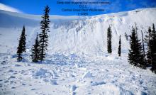
Two-step around today's primary avalanche concerns, and you can enjoy great riding. Look for - and avoid - firm but thin slabs of drifted snow at mid and upper elevations. A rider was caught and carried in a one of these Wednesday. These slabs will grow thicker and more common with today's winds. Steer around steep, shaded terrain at mid-elevations, where you can still trigger slabs that break 1 to 2 feet deep on weak snow buried in mid-January.

2. Moderate
?
Above 6500 ft.
2. Moderate
?
5000-6500 ft.
1. Low
?
3500-5000 ft.
- 1. Low
- 2. Moderate
- 3. Considerable
- 4. High
- 5. Extreme
-
Type ?
-
Aspect/Elevation ?
-
Likelihood ?CertainVery LikelyLikelyPossible
 Unlikely
 -
Size ?HistoricVery LargeLargeSmall

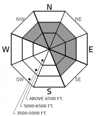
Since Sunday, upper elevations have seen gusty southwesterly winds that have formed thin but hard slabs that can be surprisingly dangerous. These are somewhat scattered through mid- and upper elevation terrain, with some reports of no drifting and one report of a rider getting caught and carried. Beware of fresh, firm drifts on steep slopes, especially those where the winds are actively blowing snow around. With more gusty winds today, this problem will become more widely distributed.
-
Type ?
-
Aspect/Elevation ?
-
Likelihood ?CertainVery LikelyLikelyPossible
 Unlikely
 -
Size ?HistoricVery LargeLargeSmall

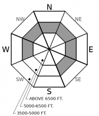
The most widespread concern in the snowpack? Still the surface hoar and facets that formed during the mid-January dry spell. These are now buried 10-30 inches below the snow surface and often show as a distinct gray stripe visible when you dig down. Steep, mid-elevation slopes open to the sky are the most concerning spots. Keep your guard up as you pass through terrain like this on your way down from, or up to, ridges. Be suspicious of typically innoucuous slopes like road cuts and gully walls, where small slides can have big consequences. Shooting cracks and whumpfing collapses are red flag signs that this hazard is alive and well.
-
Type ?
-
Aspect/Elevation ?
-
Likelihood ?CertainVery LikelyLikelyPossible
 Unlikely
 -
Size ?HistoricVery LargeLargeSmall

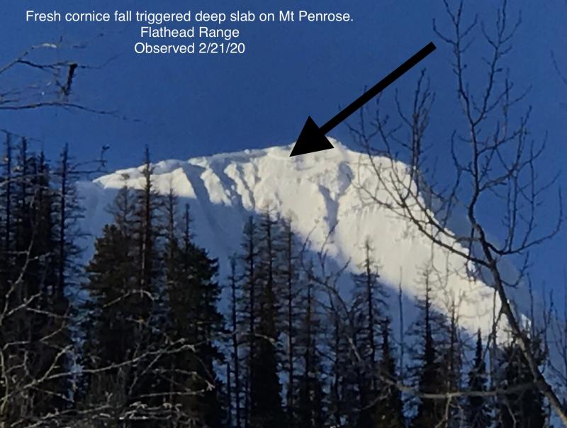
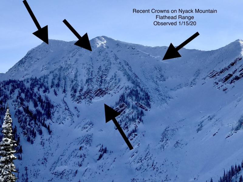
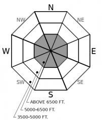
In the rocky, alpine terrain of the Flathead Range and Glacier Park, snow cover is variable and persistent weak layers formed early in the season may remain weak. The likelihood of triggering a slide that breaks on these deeply buried weak layers has diminished. In the last few weeks, it's taken large triggers - cornice falls and smaller slabs - to initiate slides on deeply buried weak snow. It's unlikely but not impossible for a single rider to trigger a big slide. Be wary near rock bands and at the margins of slabs where the snowpack gets thinner. Be mindful of these areas overhead as you ascend.
You don’t want to get all busted up. So listen up. Main ways you might ruin your day: Trigger a slab that breaks on old snow above a mid-elevation terrain trap. Or get caught in freshly-drifted snow on a steep slope. Two-step around these hazards and you can enjoy some great riding. The first is widespread through the forecast region; the second is distributed more randomly, so the dance is a little different for each.
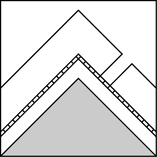
Hazard one is the Persistent Slab avalanche problem we’ve been describing since January 17, when storms buried a buffet of weak layers that formed during the inversions. That layer is now buried 12 to 24 inches deep across the forecast region. It’s been consistently produced signs of instability on mid-elevation slopes that face northwest through north to southeast. You can visualize that with this graphic. The 1/17 interface generally remains a concern where it’s well-preserved surface hoar, which is often visible as a gray stripe in the snowpack, like this.
Though this problem has quieted in the benign weather of the past few days, it still demands some respect. As you climb up or ride down through this ring o-trouble (aka The Moat of Alligators), beware of steep slopes that are open to the sky but sheltered from most sun and wind. If you find one of these, dig down with your hands and look for the gray stripe. You can also sidestep this hazard by sticking to slopes that get sustained sun, or very little sun because they’re densely treed. Mid-elevation is pretty broad in this case – from about 4500 to 6500 feet. So think below ridges and above valley floors. The slopes you travel to and from your main riding.
Hazard two has developed over the past few days, as gusty winds have drifted snow onto steep mid- and upper-elevation slopes. Wind speeds have not been sustained enough to make for widespread drifting, and many windward slopes have limited snow available for transport, because of sun crusts at or just below the snow surface. There are exceptions, however; these are mostly in the Flathead Range and Marias Pass area, where Sunday night’s storm left up to 10 inches of low-density snow for the winds to blow around. The wind slabs that have formed seem to be sensitive to a the weight of a rider or snowmobile, as demonstrated Wednesday when a rider was caught and carried in a thin but wide slab of hard, drifted snow. Because the winds have deposited these slabs on weak snow, you might trigger them from below or from unusual spots. Give any drifted snow a wide berth today.
We continue to list Deep Persistent Slab (DPS) as an avalanche problem for the Flathead Range and Glacier National Park. It's been little over a week since the last reported deep slabs in this area (Skiumah Lake, Essex Creek). That’s not long enough to shelve this concern, because the cold snowpack and rocky terrain of this zone generally harbors deep slab problems longer than the Whitefish or the Swan Ranges. Keep avoiding steep, convex slopes where the snow cover is likely to be variable due to bouts of wind loading and scouring.
EDUCATION: It's a great time to hone your avalanche knowledge or start learning the basics. Ladies Avalanche Awareness Talk - Kalispell Brewing Company -01/30/2019 6:30 PM.
Sign up for one of our upcoming classes: Motorized Introduction to Avalanches 01/31/2019 to 02/02/2019, Companion Rescue Clinic 02/09/2019 and Introduction to Avalanches (non-motorized) 02/28/2019 to 03/02/2019.
Southwest flow starts breaking down the ridge of high pressure today. Expect gusty winds and slightly warmer temperatures in the mountains today, with bands of clouds sweeping through. A potent storm may be developing late Saturday.
This forecast applies only to backcountry areas outside established ski area boundaries. The forecast describes general avalanche conditions and local variations always occur. This forecast expires at midnight on the posted day unless otherwise noted. The information in this forecast is provided by the USDA Forest Service who is solely responsible for its content.


