| Monday | Monday Night | Tuesday | |
|---|---|---|---|
| Cloud Cover: | Partly Cloudy | Mostly Clear | Partly Cloudy |
| Temperatures: | 20 to 26 deg. F. | 10 to 13 deg. F. | 18 to 24 deg. F. |
| Wind Direction: | Northwest | Northwest | Southwest |
| Wind Speed: | 11G22 | 9 | 14G30 |
| Snowfall: | 0" in. | 0" in. | 0" in. |
| Snow Line: | 1500' | 1000' | 500' |
Whitefish Range
Flathead Range and Glacier National Park
How to read the forecast
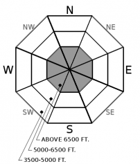
In areas without a stout near-surface crust, you can impact a buried weak layer 1-3' below the surface, resulting in a larger slide. That hazard is relatively widespread at upper-elevations and isolated at mid-elevations. When in doubt, default to planar slopes less than 35 degrees with runouts free of surface obstacles and terrain traps.

2. Moderate
?
Above 6500 ft.
1. Low
?
5000-6500 ft.
1. Low
?
3500-5000 ft.
- 1. Low
- 2. Moderate
- 3. Considerable
- 4. High
- 5. Extreme
-
Type ?
-
Aspect/Elevation ?

-
Likelihood ?CertainVery LikelyLikelyPossible
 Unlikely
 -
Size ?HistoricVery LargeLargeSmall

We have not received a report of a slide failing on a buried weak layer since the 1/13 storm, but observations have been sparse. There are 2 layers of buried surface hoar we are monitoring. The most reactive one is approximately 1 foot below the surface with another 2-3 feet down. Unfortunately, the only way to know their existence is by digging into the snow. They generally appear as a thin grey stripe and fail during snowpit tests. In areas where the surface consists of a thick hard crust, it is unlikely that you or your machine's weight can impact them. Slopes without a crust, or where the crust is thin and breakable, are most suspect. If you are unsure, utilize terrain to your advantage by avoiding steep rollovers or slopes which end in a terrain trap. Stick to planar slopes less than 35 degrees in steepness for a safer experience.
A quick-hitting disturbance passed through our area yesterday morning. Precipitation and snow totals were modest, except for the Swan Range, which picked up 1.1” of water and 8” of snow in a 7-hour window at Noisy Basin.
Let us take a closer look at these numbers. The density of the freshly fallen snow at Noisy Basin was approximately 14% (Density=mass/volume or 1.1/8 x 100). To help put this into context, Steamboat, Colorado boasts about its 6% champagne powder. The temperature at Noisy during the snowfall event was 27 - 28 F, which coincides with snow a bit on the heavy side. It is unusual for a storm slab to form in 6% snow, but more common in 14% snow. Denser snow = more cohesive snow. Now let’s look at the precipitation intensity. 8” of snow over a 7 hour period equates to over an inch of snow an hour. That is dumping! More, please! That rate exceeds the rule of thumb of a loading threshold of 1” per hour. The higher the precipitation intensity the greater the chance of failure (and fracture) in the fresh snow.
An observer in the Swan noted a natural storm slab cycle with 4-6” crowns on top of the 1/13 crust. This cycle occurred because the more cohesive 14% snow was deposited at a high intensity leading to failure. Having a stout, slick rain crust for a sliding surface was the final ingredient required for a slab avalanche to occur. Perhaps there was a thin layer of weak snow on top of the crust which added fuel to the fire. Off to the storm slab races, went the Swan.
Blase was in the southern Whitefish Range with FAC interns Jeremy and Zach. They found dust on a stout crust on southerlies, up to 6” on a less robust crust on northerlies, and triggered sluffs skiing both of these aspects. They noted a widespread storm slab avalanche cycle from the Pineapple Express. Slides were generally D1 to D2 with 2 D3 slides in this heavily used backcountry location.
In honor of Martin Luther King Jr. Day, I will leave you with a couple of his quotes that are appropriate for these times.
“The time is always right to do what is right.”
“The ultimate measure of a man is not where he stands in moments of comfort and convenience, but where he stands at times of challenge and controversy.
Expect a quiet day with seasonable temperatures, light winds, and partly cloudy conditions. A weak system may move into our area Tuesday night into Wednesday.
This forecast applies only to backcountry areas outside established ski area boundaries. The forecast describes general avalanche conditions and local variations always occur. This forecast expires at midnight on the posted day unless otherwise noted. The information in this forecast is provided by the USDA Forest Service who is solely responsible for its content.


